
Severe Weather Risk Expands Across Missouri, Illinois, Indiana and Kentucky on February 19 as SPC Issues 15% Slight Risk — First Day 4 Outlook in 121 Days
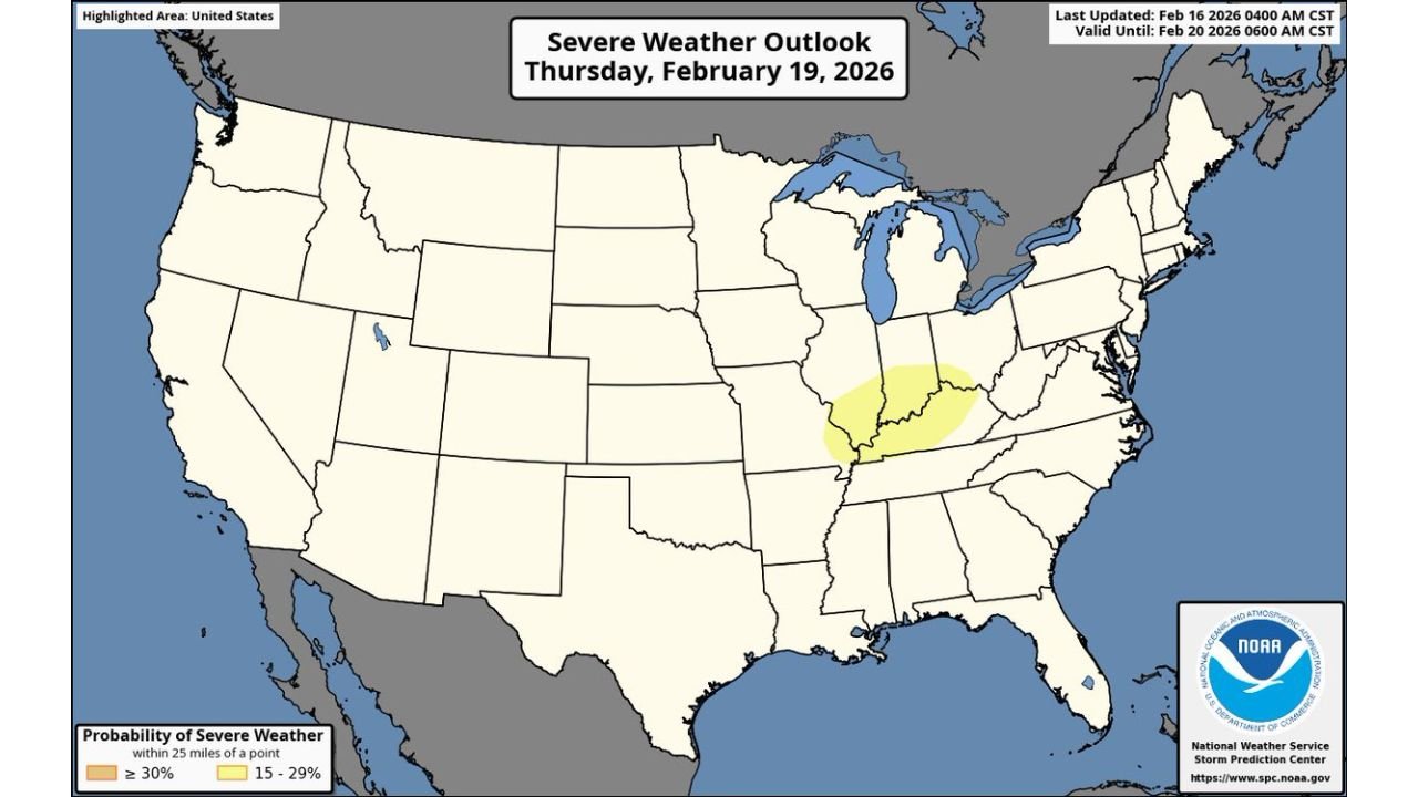
UNITED STATES — The Storm Prediction Center (SPC) has issued a 15% severe weather probability area (equivalent to a Level 2 out of 5 “Slight Risk”) for Thursday, February 19, 2026, highlighting parts of the Midwest and Ohio Valley for potential strong storms.
The highlighted yellow region stretches across portions of:
- Eastern Missouri
- Southern and Central Illinois
- Central and Southern Indiana
- Western and Central Kentucky
- Nearby surrounding areas
This marks the first Day 4 risk area issued since October 18 of last year — a 121-day stretch without one, underscoring the increasing confidence in a potentially organized setup.
What the 15% Risk Means
A 15% probability area means there is at least a 15 percent chance of severe weather occurring within 25 miles of any given point inside the shaded zone.
While it is too early for storm-by-storm details, this level of outlook typically signals:
- A favorable large-scale pattern
- Increasing confidence in storm development
- The potential for organized thunderstorm clusters or lines
At this stage, forecasters are watching evolving atmospheric ingredients that could support damaging winds, hail, or even isolated tornado potential depending on how the system evolves.
Cities in the Highlighted Zone
Based on the map, communities that should closely monitor updates include:
- St. Louis, Missouri
- Springfield, Illinois
- Peoria, Illinois
- Indianapolis, Indiana
- Louisville, Kentucky
- Evansville, Indiana
- Surrounding areas across southern Illinois and central Kentucky
The risk area sits along a corridor frequently active during early-season severe weather setups.
Why This Outlook Stands Out
The issuance of a Day 4 15% risk is notable because:
- It indicates higher-than-average model agreement several days in advance.
- It’s the first time in over four months that this level of early outlook has been issued.
- It signals the possible transition into a more active late-winter severe weather pattern.
Late February often marks the beginning of increasing severe weather frequency across the central United States as Gulf moisture returns northward and strong upper-level systems sweep through.
Still Too Early for Specific Hazards
Forecasters stress that:
- Exact storm modes are still uncertain.
- The placement of the warm sector and instability axis may shift.
- The risk area could expand, contract, or move slightly as new data comes in.
Residents within the yellow-shaded region should use the next few days to review severe weather safety plans and monitor official forecast updates.
What Happens Next
As Thursday approaches, higher-resolution models will better define:
- Timing of storms
- Storm structure (supercells vs. squall line)
- Primary hazard threats
Additional outlook updates from the SPC may adjust probabilities or introduce more defined hazard categories.
For now, the message is simple: if you live in or near the yellow shaded region across Missouri, Illinois, Indiana, and Kentucky, stay alert over the next few days.
WaldronNews.com will continue tracking forecast updates as the February 19 severe weather setup becomes clearer.