
Sierra Nevada Braces for Extreme Snow Event as ECMWF Signals 4 to 8 Feet Widespread and Isolated 100+ Inch Totals Across California High Country
CALIFORNIA — A prolonged and powerful winter pattern is poised to unload massive snowfall totals across the Sierra Nevada over the next week, with some high-elevation locations potentially surpassing 100 inches of accumulation if current projections verify.
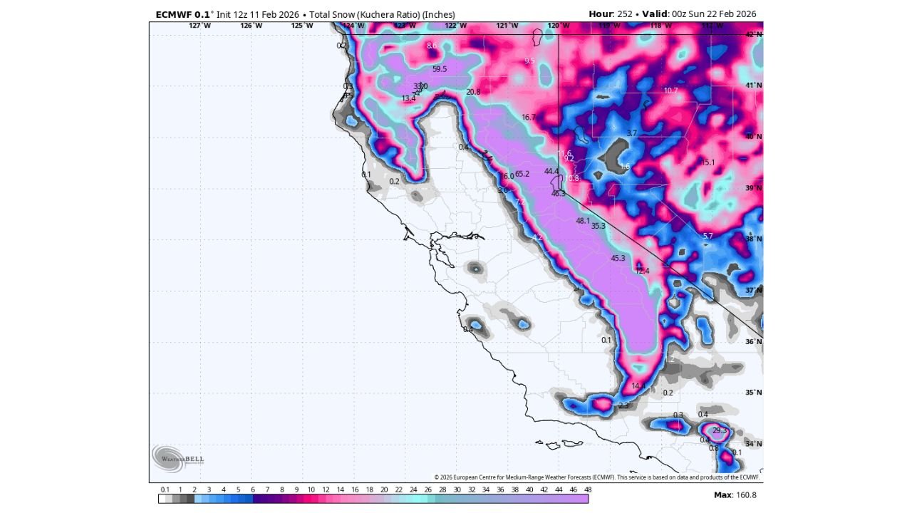
Latest ECMWF (European) model guidance through February 22 shows a broad swath of extreme snow totals stretching the length of the Sierra Nevada, from near the Oregon border south through central California and into the southern Sierra.
Widespread 4–6 Feet Along the Sierra Crest
The model’s total snow projection highlights:
- 40 to 60 inches common along much of the Sierra crest
- Numerous areas exceeding 60 inches (5 feet)
- Pockets surpassing 70–80 inches in higher elevations
From near Mount Shasta in northern California through Lake Tahoe, down past Yosemite National Park, and into the southern Sierra near Mammoth Mountain, heavy snowfall appears widespread and sustained.
This is not a quick-hitting system — the totals suggest multiple rounds of Pacific moisture targeting the same terrain over several days.
Isolated 100-Inch Totals Possible in Higher Terrain
The highest elevations of the central Sierra show extreme signals, with isolated projections exceeding 100 inches (over 8 feet).
These totals would most likely occur in:
- The highest ridgelines
- Wind-favored west-facing slopes
- Elevated ski resort terrain
While precise amounts will fluctuate in coming model runs, the signal for an exceptionally high-impact snow cycle is strong.
Snowfall Confined Largely to Higher Elevations
Valley locations across California, including:
- Sacramento
- San Joaquin Valley
- Coastal areas
are projected to see little to no snowfall, with accumulations confined primarily to mountainous regions.
However, heavy precipitation and strong winds at higher elevations could lead to:
- Difficult to impossible travel over major passes
- Avalanche concerns
- Significant disruptions along key corridors such as I-80 near Donner Pass and Highway 395
Southern Sierra Also Targeted
The southern Sierra, including areas near Sequoia National Park and north of Los Angeles in higher elevations, also shows substantial totals.
While lower elevations in Southern California remain largely rain-focused, mountain communities could see several feet of accumulation.
What This Means for California
For ski resorts and water supply outlooks, this event could be highly beneficial in terms of snowpack growth. However, the short-term impacts may be significant:
- Chain controls likely across major mountain highways
- Potential temporary road closures
- Heavy snow loading on structures in mountain towns
The persistence of Pacific moisture into the Sierra Nevada over multiple days is the key driver behind these extreme totals.
Waldronnews.com will continue monitoring model trends to determine whether this snow event intensifies further or adjusts in placement as the storm sequence unfolds across California’s high country.