
Sierra Nevada Braces for Potential 150+ Inches of Snow as Powerful Pacific Storm Track Targets California Mountains Over Next Two Weeks
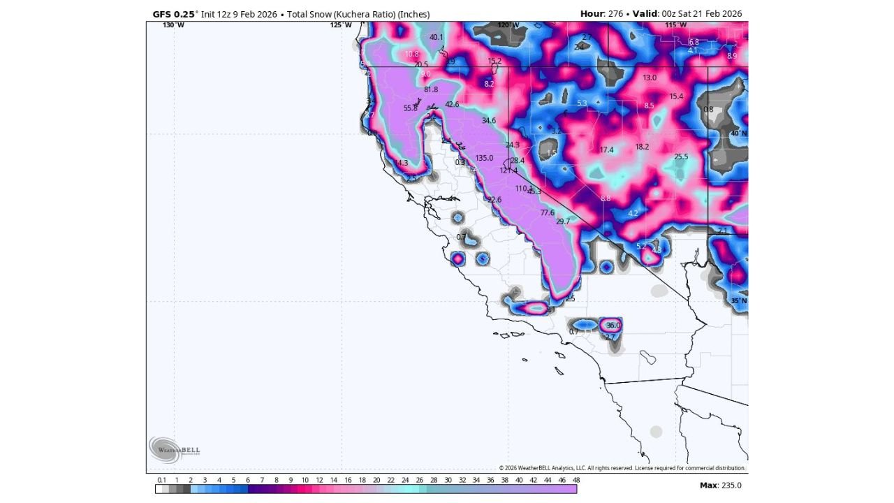
CALIFORNIA — The Sierra Nevada is shaping up for an extraordinary stretch of winter weather, with long-range model data indicating the potential for well over 150 inches of snow across higher elevations over the next two weeks, as a persistent Pacific storm track locks into place over the western United States.
The data highlights a prolonged period of frequent, moisture-rich systems impacting the spine of California, with snowfall piling up storm after storm — a pattern that strongly favors extreme accumulations in the high Sierra.
Storm Train Sets Up Over the West
Forecast guidance shows a steady parade of Pacific systems moving inland, with little downtime between storms. This setup allows cold air to remain entrenched over the Sierra Nevada while deep Pacific moisture repeatedly reloads, maximizing snowfall potential.
Instead of one major storm, this appears to be a cumulative event, where multiple snow-producing systems stack totals rapidly over time.
Where the Heaviest Snow Is Expected
The highest totals are focused along the central and southern Sierra Nevada, particularly at higher elevations, where colder temperatures ensure precipitation falls almost entirely as snow.
Model projections suggest:
- 100 to 150 inches of snow is likely in favored high-elevation zones
- Localized totals exceeding 150 inches are possible where terrain enhancement is strongest
- Lower elevations and foothill areas still see significant snow, but with sharply reduced totals compared to the peaks
Areas near and east of the Sierra crest, including regions around Lake Tahoe and the high country farther south, stand to benefit most from this pattern.
Excellent News for Ski Resorts, But Impacts Likely
For ski resorts and winter recreation, this is outstanding news, promising deep base-building snow and prolonged winter conditions.
However, the same pattern also raises concerns for:
- Difficult mountain travel, especially during active storm periods
- Chain controls and road closures on major Sierra passes
- Increased avalanche risk due to rapid snow loading
Travel through the mountains may become hazardous at times, particularly during stronger storms embedded within the pattern.
Snow Totals Still Subject to Change
While confidence is growing in a very snowy two-week period, exact totals will depend on:
- Storm intensity and spacing
- Snow levels during individual systems
- How long the storm track remains locked in place
Even modest shifts in storm paths could significantly affect final snowfall amounts.
Bottom Line
All signs point to a historic stretch of snowfall for the Sierra Nevada, with 150 inches or more possible at higher elevations as repeated Pacific storms batter California’s mountains through the next two weeks. It’s a dream scenario for skiers — but one that also demands caution for anyone traveling through the high country.
WaldronNews.com will continue monitoring this evolving winter pattern and provide updates as confidence increases and individual storms come into clearer focus.