
Snow Reported From Minnesota to South Florida as Rare Winter Storm Pushes Flakes to Naples for First Time Since 1989
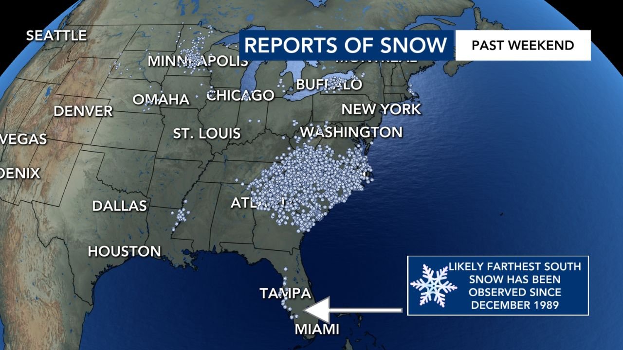
UNITED STATES — A rare and expansive winter weather event unfolded over the past weekend as snow was reported across a massive stretch of the country, extending from Minnesota through the Midwest, the Ohio Valley, the Southeast, and all the way into South Florida, marking one of the southernmost snow observations in decades.
According to mapped reports compiled from weather observers and federal data, snow fell across dozens of states, with confirmed reports reaching Naples, Florida, an area that has not documented snowfall this far south since December 1989.
Snow Reports Span the Midwest, East Coast, and Deep South
Snowfall reports were concentrated across a broad corridor of the eastern United States, including:
- Upper Midwest: Minnesota, Wisconsin, Michigan
- Great Lakes & Midwest: Illinois, Indiana, Ohio
- Mid-Atlantic & Northeast: Pennsylvania, New York, Washington, D.C.
- Southeast: Kentucky, Tennessee, North Carolina, South Carolina, Georgia
- Florida: Reports extending south through Tampa and into Naples
The density of reports was especially high across the Carolinas and the southern Appalachians, where cold air combined with moisture to support widespread snow accumulation uncommon for early February at these latitudes.
Naples, Florida Marks Southernmost Snow Report in Over 35 Years
One of the most significant aspects of this event was the southern reach of snowfall into South Florida.
Weather data indicates that Naples experienced snow, making this the furthest south confirmed snow report since December 1989, according to historical NOAA records. Snowfall in this region is extremely rare due to typically mild winter temperatures and proximity to the Gulf of Mexico.
Even brief or trace snowfall in this area is considered climatologically significant.
Cold Air Surge Allowed Snow to Reach Unusual Latitudes
Meteorological analysis shows that a strong Arctic air mass plunged southward during the weekend, overwhelming normally warm southern regions and allowing snow to reach areas that typically only experience cold rain or brief flurries.
The combination of:
- Deep cold air
- Favorable upper-level dynamics
- Sufficient moisture
created conditions capable of producing snow far beyond the usual winter boundary.
Why This Snow Event Stands Out Nationally
This event is notable not just for snowfall totals, but for its geographic scale and historical rarity. Snow reports spanning from the Upper Midwest to South Florida highlight how unusual the atmospheric setup was.
Events that produce measurable or observed snow across such a wide north-to-south range are extremely uncommon and typically occur only during the strongest winter outbreaks.
What Happens Next
While temperatures are expected to moderate in many southern areas, meteorologists note that February remains a volatile month, and additional cold snaps are still possible. Residents in southern states are advised to remain weather-aware, especially when rare winter precipitation is involved, as infrastructure and road conditions are often unprepared for snow and ice.
What do you think — is winter becoming more unpredictable, or was this a once-in-a-generation setup? Share your thoughts and follow continued national weather coverage at WaldronNews.com.