
South Carolina Lowcountry and Coastal Georgia Placed Under Winter Storm Warning as Rare Snow Event Targets the Southeast
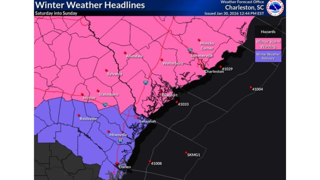
SOUTH CAROLINA — A rare winter weather event is unfolding across the Southeast, with Winter Storm Warnings now in effect for the South Carolina Lowcountry and portions of coastal and inland Georgia, as snow becomes increasingly likely from Saturday morning through Sunday afternoon.
According to the latest weather data and regional forecast guidance, snow observation equipment has already been deployed in anticipation of measurable snowfall, signaling high confidence that this will not be a routine cold snap, but a significant winter weather event for areas that rarely experience snow.
Winter Storm Warning Issued for SC Lowcountry and Multiple Georgia Counties
A Winter Storm Warning is in effect from 7 a.m. Saturday through 1 p.m. Sunday for:
- South Carolina Lowcountry, including Charleston-area coastal counties
- Georgia counties: Effingham, Bulloch, Candler, Jenkins, and Screven
These areas are expected to see accumulating snowfall, with impacts likely to include hazardous travel conditions, slick bridges, and possible disruptions to weekend plans.
Forecasters note that the warning area aligns closely with the corridor of strongest lift and cold air overlap, increasing confidence in snowfall rather than cold rain.
Winter Weather Advisory South of I-16
Areas south of Interstate 16, including parts of coastal Georgia closer to Savannah and Darien, are under a Winter Weather Advisory, where lighter snow accumulations or mixed precipitation are possible.
While totals may be lower in advisory zones, even light snow is enough to create dangerous road conditions in regions unaccustomed to winter precipitation.
Snow Boards Deployed as Confidence in Snowfall Grows
Photos accompanying the advisory show snow boards and measurement equipment already deployed, a step typically taken only when measurable snow is expected.
This suggests forecasters anticipate:
- Snow reaching the ground
- Enough accumulation to be measured
- Potential verification of rare climatological snowfall for coastal Southeast locations
Broader Southeast Snow Potential Still Under Monitoring
Earlier outlooks indicate:
- 4–6 inches of snow possible across parts of the Carolinas
- Localized 8+ inch totals in eastern North Carolina and near the Outer Banks
- Light snow potential extending into Alabama, Tennessee, and Kentucky
However, forecasters stress that snow totals remain sensitive to the exact track of the coastal low-pressure system, particularly near the Georgia and South Carolina coastline.
Why This Storm Is Unusual
This event is being driven by:
- A strong Arctic air mass pushing deep into the Southeast
- A developing coastal low drawing moisture inland
- Temperatures cold enough to support snow far south of typical winter storm tracks
For many locations in coastal South Carolina and Georgia, snowfall of this magnitude is uncommon enough to be considered a high-impact event, even if totals remain modest by northern standards.
What Residents Should Do Now
Officials advise residents in warning and advisory areas to:
- Avoid unnecessary travel during snowfall
- Protect exposed pipes, pets, and plants
- Monitor local weather updates for timing changes or upgraded alerts
Even small accumulations can lead to significant impacts in areas without winter road treatment infrastructure.
Stay With WaldronNews
WaldronNews will continue tracking this developing winter storm, including snowfall reports, warning updates, and regional impacts across the Southeast. Check back frequently for the latest updates as conditions evolve.