
South Carolina, North Carolina, and Georgia Emerge as Snow-Favored Zone as Confidence Grows for a Weekend Winter System
UNITED STATES — A developing winter weather pattern is drawing increased attention across South Carolina, North Carolina, and Georgia, where forecasters say confidence is gradually rising that a weekend system could favor snow, even as critical details remain uncertain several days out.
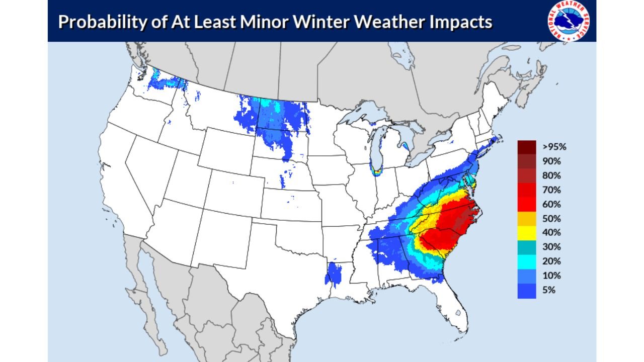
Forecast guidance issued Tuesday shows a concentrated corridor of higher probabilities for at least minor winter weather impacts stretching from the southern Appalachians into the central and eastern Carolinas, with northern and central Georgia also included in the broader risk zone. While this does not guarantee snowfall, it signals that atmospheric conditions are aligning in a way that makes wintry precipitation increasingly plausible as the weekend approaches.
Why Confidence Is Increasing — But Details Are Still Limited
Meteorologists emphasize that this system remains 3 to 5 days away, a range where broad trends become clearer but exact timing, placement, and snowfall amounts are still low-confidence. At this stage, models are better at identifying where winter weather is possible than how much or when it will occur.
The current pattern favors:
- A storm track capable of supporting cold air in place across parts of the Southeast
- A developing moisture feed that could overlap with subfreezing air
- A setup that historically increases the risk of snow or mixed winter precipitation in the Carolinas and adjacent states
However, small shifts in temperature or storm track — sometimes as little as 50 to 100 miles — could significantly change outcomes.
What the Probability Maps Are Actually Saying
The probability outlook does not indicate a major winter storm at this time. Instead, it highlights areas most likely to experience at least minor winter impacts, such as:
- Light snow accumulations
- Brief travel disruptions
- Slick roads, especially overnight or early morning
The highest probabilities are currently centered over portions of South Carolina and North Carolina, with surrounding areas of Georgia included in lower—but still notable—impact probabilities.
Forecasters caution that these probabilities can increase or decrease quickly as newer data refines the storm’s evolution.
Why This Setup Is Being Watched Closely
Winter weather events in the Southeast are often high-impact even at low accumulations, particularly due to limited snow-removal infrastructure and rapid temperature swings. This is why meteorologists begin highlighting these setups days in advance, even when confidence is still developing.
The atmospheric pattern responsible for this potential event is also part of a broader stretch of below-normal temperatures, which increases the likelihood that any precipitation that falls could do so as snow rather than rain.
What Happens Next
Forecasters will be watching:
- How quickly cold air locks in across the Carolinas and Georgia
- Whether the storm system tracks far enough south to maximize snow potential
- Nighttime temperature trends heading into Saturday and Sunday
Clearer answers on timing, precipitation type, and possible accumulations are expected as the event moves within the 48–72 hour window.
Bottom Line
There is growing confidence in a winter weather setup that favors snow across South Carolina, North Carolina, and parts of Georgia this weekend. While details remain uncertain, the signal is strong enough to warrant close monitoring through the week.
Residents across the region should stay informed, especially if travel plans are scheduled for late Saturday or Sunday.
WaldronNews will continue tracking this system closely and provide updates as confidence increases.