
South-Central Oklahoma Under Slight Risk for Severe Storms Sunday as SPC Highlights Norman–Ada Corridor for Damaging Hail and Winds
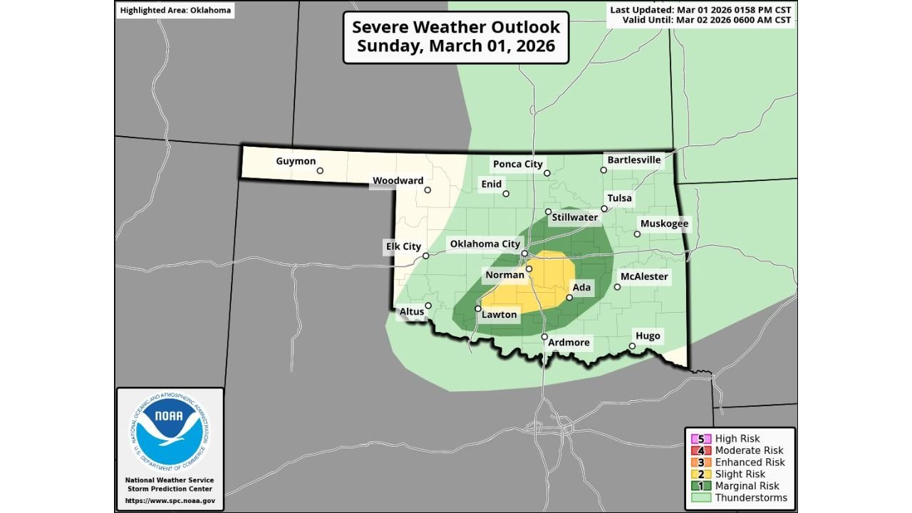
OKLAHOMA — The Storm Prediction Center (SPC) has upgraded portions of south-central Oklahoma to a Level 2 out of 5 (Slight Risk) for severe weather today, Sunday, March 1, 2026, as atmospheric conditions become more supportive of strong thunderstorms capable of producing damaging hail and gusty winds.
The updated outlook, valid through 6:00 AM CST Monday (March 2), places the highest concern across areas just south and southeast of Oklahoma City.
Slight Risk Zone Focused Near Norman, Ada and Lawton
The SPC outlook map shows a concentrated yellow-shaded area — indicating the Slight Risk — stretching across parts of:
- Norman
- Ada
- Lawton
- Areas between Oklahoma City and Ardmore**
The broader green-shaded region (Marginal Risk) expands outward to include:
- Oklahoma City
- Stillwater
- Tulsa
- Muskogee
- McAlester
- Ardmore
- Altus
- Portions of southern and central Oklahoma**
This means scattered severe storms are possible, with the greatest concentration expected in south-central sections of the state.
Main Threats: Large Hail and Severe Winds
According to the SPC discussion accompanying the outlook, the environment is improving enough to support:
- Damaging straight-line winds
- Large hail
- Locally intense thunderstorms
While tornado risk is not emphasized in this update, any strong storm in a Slight Risk environment can become briefly severe.
Storm development is expected to occur later today as instability increases and lift strengthens across the highlighted corridor.
Timing Window
The severe weather outlook is valid from Sunday afternoon into the overnight hours, expiring at 6:00 AM CST Monday.
Storms could develop during the late afternoon or evening hours, especially near and south of the Oklahoma City metro, then move eastward across south-central Oklahoma.
Residents in Norman, Ada, Lawton, and surrounding communities should monitor radar closely through the evening.
Why South-Central Oklahoma Is the Target
The Slight Risk placement suggests the strongest overlap of:
- Increasing instability
- Stronger wind shear
- Favorable lifting mechanisms
The map shows the core risk zone positioned just southeast of Oklahoma City — a classic early-spring setup where warm, moist air interacts with a passing disturbance.
Even isolated storms in this type of setup can produce pockets of significant hail or damaging wind gusts.
Broader Impact Area
Outside the Slight Risk zone, much of central and eastern Oklahoma remains under a Marginal Risk. That includes Tulsa and Muskogee, where storms are possible but less likely to reach widespread severe criteria.
However, weather patterns can evolve quickly, and any strengthening storm could briefly intensify.
Stay Weather-Aware
Residents across south-central Oklahoma should:
- Have multiple ways to receive warnings
- Secure loose outdoor items
- Stay alert for rapidly changing weather conditions this evening
For continued updates on this developing severe weather setup and regional storm coverage, stay with WaldronNews.com for the latest forecast analysis and safety information.