
Southeast Alabama Faces Low-Probability but High-Impact Tornado Risk as Storms Approach Saturday
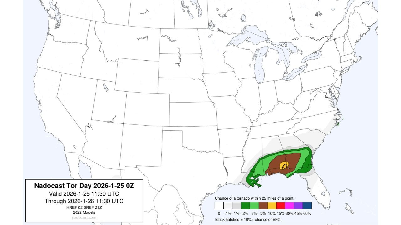
SOUTHEAST ALABAMA — A small but concerning tornado risk is emerging across parts of southeast Alabama on Saturday, where atmospheric conditions could briefly allow a stronger, long-track tornado to develop ahead of a fast-moving line of storms.
While the overall threat remains limited in coverage, meteorologists warn that any storm that becomes discrete before merging into a squall line could rapidly intensify, producing a tornado capable of significant damage.
Why Southeast Alabama Is the Focus Area
Forecast guidance highlights southeast Alabama as the primary area where ingredients may briefly align for tornado development. This region sits near the eastern edge of stronger instability and wind shear, creating a narrow window for storms to rotate.
Model data shows:
- Increasing low-level wind shear ahead of the main storm line
- Enough instability to support rotating updrafts
- A short timeframe where storms may remain isolated
If storms remain clustered, the tornado threat stays low. If one storm breaks ahead of the line, the risk rises quickly.
What Makes This Risk Different From a Typical Line of Storms
Most storms are expected to arrive as a squall line, which usually limits tornado strength and duration. However, the data shows a non-zero chance of a supercell forming ahead of that line, particularly during the late afternoon and evening hours.
This matters because:
- Supercells are more capable of producing stronger tornadoes
- Even brief rotation can result in rapid damage
- Tornadoes may form with little warning
While probabilities remain low, impact potential is higher than average for January if a storm becomes surface-based.
Tornado Strength: Low Probability, Higher Consequences
Forecast probabilities indicate:
- A low overall chance of tornado development
- A very small but real chance of a stronger (EF2 or higher) tornado
This does not mean a tornado is likely — but it does mean residents should treat warnings seriously if storms intensify faster than expected.
Timing and Storm Evolution
Current guidance suggests:
- Storms move into southeast Alabama Saturday afternoon
- The highest tornado risk window is just ahead of the main line
- Once storms consolidate into a solid line, the tornado threat decreases
Damaging winds and heavy rain remain the primary hazards for most locations.
What Residents Should Do
Because tornadoes in this setup can form quickly:
- Stay weather-aware throughout the day
- Ensure warnings can be received overnight if storms slow
- Know where to shelter if a warning is issued
Even a low-probability event can become dangerous if people are caught off guard.
Bottom Line
Southeast Alabama is facing a limited but higher-impact severe weather setup on Saturday. Most areas will see storms with wind and rain, but a narrow window exists for a stronger tornado if storms briefly organize ahead of the main line.
Residents should remain alert, not alarmed — and be ready to act if conditions change quickly.