
Southeast and East Coast States Including Georgia, the Carolinas, Virginia, and the Northeast Face Uncertain Winter Storm Potential as Arctic and Pacific Systems Eye Possible Late-Week Phase
UNITED STATES — Forecast confidence remains low but increasingly watchful as meteorologists analyze a complex winter pattern setting up for late next week, one that could eventually impact parts of the Southeast and East Coast, depending on how two major atmospheric systems interact.
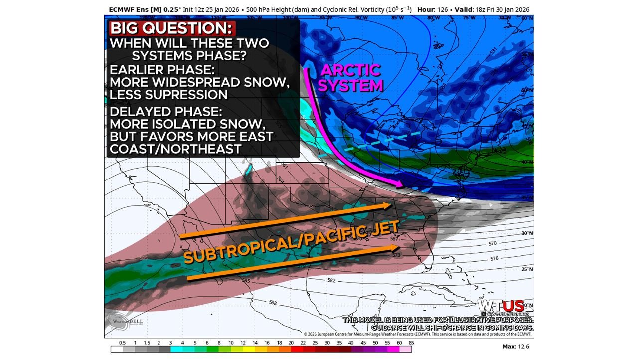
Current long-range guidance — still 5 to 7 days out — shows an Arctic wave diving south from Canada while an active Subtropical/Pacific jet stream pushes moisture eastward across the southern United States. These two features are expected to coexist late next week, but the timing and location of their interaction (or “phasing”) remains the key uncertainty.
The Core Forecast Question: When — and If — the Systems Phase
Meteorologists stress that cold air will not be the limiting factor for winter precipitation. Instead, the entire forecast hinges on how quickly the Arctic system and Subtropical jet align.
- Earlier phasing scenario:
- Stronger interaction between systems
- More widespread snow potential
- Less suppression of moisture
- Greater risk for impacts across the Southeast and portions of the East Coast
- Delayed phasing scenario:
- More suppressed storm track
- Isolated or lighter snowfall
- Greater focus toward the Mid-Atlantic, East Coast, and Northeast
- Reduced snow potential farther south
Recent model runs have leaned toward a more suppressed solution, keeping Gulf moisture farther south and limiting snowfall coverage. However, some guidance still suggests earlier phasing, aided by a sharper Arctic wave axis — a setup that could expand winter weather risks farther south and east.
Why Forecast Confidence Is Still Low
This type of Southern and Eastern U.S. winter setup is notoriously difficult to pin down at long range. Small timing differences between the Arctic plunge and Pacific jet energy can dramatically shift:
- Storm track
- Snow coverage
- Which states see meaningful impacts versus minimal effects
Forecasters emphasize that details will change, and no single outcome should be treated as locked in at this stage.
No Preparedness Call — Yet
Despite growing interest in the pattern, meteorologists are not calling for immediate storm preparations. While it never hurts to maintain basic winter readiness, this remains a pattern-monitoring phase, not a forecast for a specific storm.
Greater clarity is expected over the next several days, as shorter-range guidance begins resolving whether these systems:
- Phase early and produce broader winter impacts
- Or remain out of sync, keeping snowfall more limited and localized
Bottom Line
A potentially impactful winter pattern is taking shape for late next week, but significant uncertainty remains. The difference between a widespread Southeast-to-East Coast snow event and a more limited coastal or Northeast-focused system will come down to timing, phasing, and storm suppression — all details that are still evolving.
Stay tuned as this pattern develops. We’ll continue tracking model trends and provide updates as confidence increases. Follow the latest winter outlooks and analysis at WaldronNews.com.