
Southeast and Southern Appalachia Brace for Dangerous Heat This Week Before Stormy and Cooler Pattern Returns Late April Across the Region
NASHVILLE, Tennessee — A dramatic and rapidly evolving weather pattern is taking shape across the Southeast, Southern Appalachia, and the Tri-Cities region this week, as unseasonably hot and primarily dry conditions push temperatures into the 80s and even 90s across much of the region through April 18-19 — before a significant pattern shift brings stormier and cooler conditions back to the Southeast in the final 10 days of April.
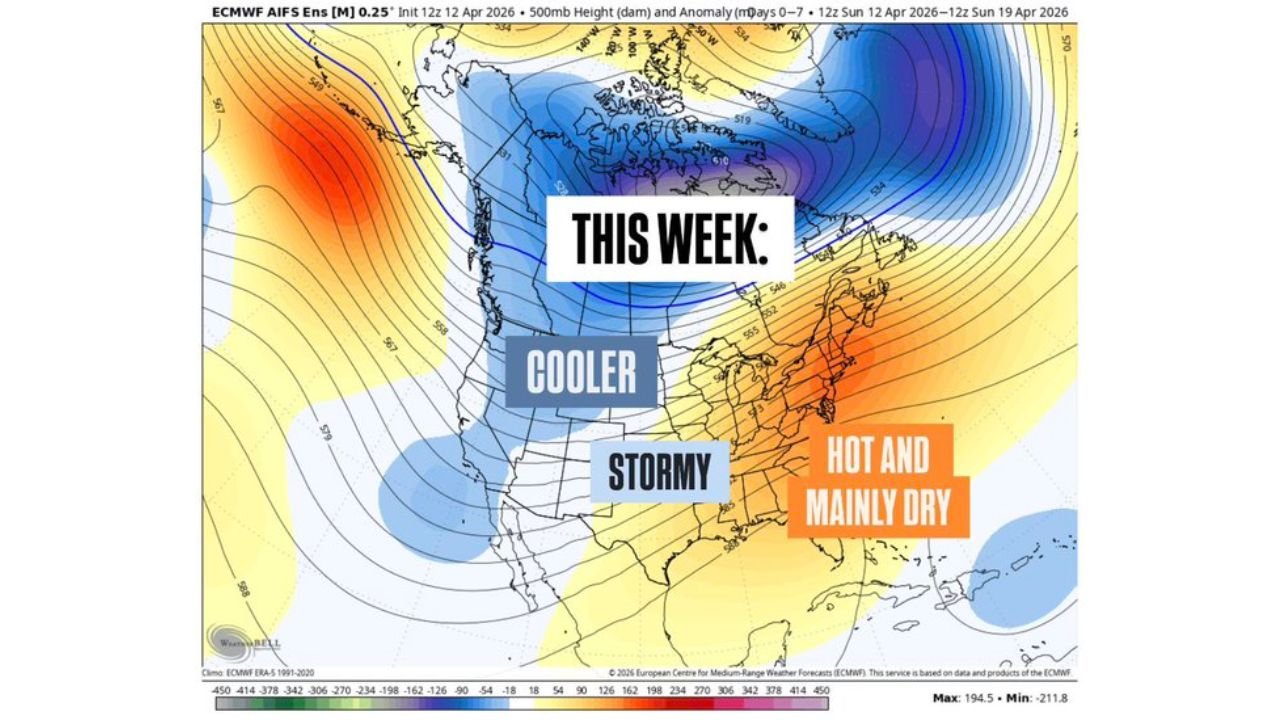
The contrast playing out across the country right now could not be more stark. While the central United States battles a historic 5-day severe weather outbreak, the Southeast including Southern Appalachia and the Tri-Cities is sitting under a heat dome delivering summer-like temperatures weeks ahead of schedule — and the atmospheric mechanism driving that shift later this month is already in motion.
Who Is Feeling the Heat This Week
- Tennessee: The Tri-Cities region — including Johnson City, Kingsport, and Bristol — along with Nashville and the broader Middle Tennessee corridor are experiencing unseasonably hot conditions with highs surging into the 80s
- Southern Appalachia: Communities across the mountain region of western North Carolina, northeast Tennessee, and southwest Virginia are seeing temperatures well above normal for mid-April
- Southeast — South and East of the Region: Areas to the south and east of Southern Appalachia are experiencing even more extreme heat with highs pushing into the 90s — making this one of the hottest April stretches in recent memory for parts of the Deep South
- Broader Southeast: The hot and mainly dry pattern shown on the upper-level map covers the entire eastern United States from the Tennessee Valley southward through the Gulf Coast states
What Is Driving the Heat — And What Ends It
The current heat pattern is being driven by a dominant upper-level ridge — a dome of high pressure sitting over the eastern United States that is suppressing storm development and allowing temperatures to soar well above seasonal averages. This ridge is clearly visible on the 500mb anomaly map showing a large area of positive height anomalies — meaning the atmosphere is running significantly warmer and more stable than normal — draped across the Southeast and Mid-Atlantic.
But the pattern is not permanent. A large-scale atmospheric wave known as the Madden-Julian Oscillation is currently on the move, cycling through phases 8, 1, and 2 — a progression that historically brings increased storm activity and eventually cooler conditions back to the Western Hemisphere. This is the same type of atmospheric shift seen in March 2023 when a similar oscillation transition helped end a prolonged dry and warm period across the Southeast.
As this wave moves east and El Niño continues to take shape in the tropical Pacific, equatorial thunderstorm activity presses further into the Western Hemisphere — and that energy eventually translates into a stormier and cooler pattern for the southeastern United States. The timeline for this transition points to around April 20, after which conditions are expected to shift meaningfully.
Two Distinct Phases — This Week vs. Late April
The weather data tells a clear two-chapter story for the Southeast through the end of April:
Now Through April 18-19 — Hot and Mainly Dry: The current upper-level pattern holds through the middle of next week, keeping the Southeast, Southern Appalachia, and Tri-Cities locked in unseasonably warm and dry conditions. Temperatures in the 80s locally and 90s to the south and east will continue dominating the forecast. Rainfall chances remain minimal across most of the region during this window, which combined with the heat creates elevated fire weather concerns for dry vegetation across the mountain communities of Southern Appalachia.
Around April 20 and Beyond — Turning Stormy and Cooler: The late-April pattern map shows a dramatic change — the positive height anomaly that has been baking the Southeast retreats and is replaced by a blue anomaly field indicating below-normal heights and a much more active storm pattern. The forecast valid for April 26-27 shows the entire central and eastern United States shifting into a stormy and cooler regime, with the ridge that defined this week’s heat replaced by a trough pattern more typical of an active spring severe weather season. Stormier conditions and eventually cooler temperatures are expected to return for the last 10 days of April.
What This Means for Southern Appalachia and the Tri-Cities
For communities across Southern Appalachia and the Tri-Cities, this week’s heat is the immediate concern. Mid-April temperatures in the 80s across the mountain region are running 10 to 15 degrees above normal for this time of year and carry real health and safety implications:
Residents with outdoor labor jobs, elderly individuals, and those without air conditioning should take the heat seriously through the middle of the week. Hydration, shade, and limiting midday outdoor exertion are essential precautions during this unseasonable heat event. The dry conditions accompanying the heat also mean that any outdoor burning or fire activity in the mountain communities of Southern Appalachia carries elevated risk this week.
The arrival of stormier conditions around April 20 also deserves advance preparation. After days of heat and dry conditions, the transition to a more active storm pattern can bring intense storms — as the atmosphere recharges moisture rapidly when the pattern breaks.
What to Watch Through the Rest of April
- Monitor daily high temperatures through April 18-19 — if the ridge holds longer than expected, the heat event could extend and intensify before the pattern break
- Fire weather awareness is important across dry mountain communities in Southern Appalachia while hot and dry conditions persist this week
- Watch for the pattern transition around April 20 — the shift from hot and dry to stormy and cooler can happen quickly and bring significant storm activity to the Southeast
- The last 10 days of April are expected to bring stormier conditions back to the region — residents across Tennessee, the Tri-Cities, and Southern Appalachia should stay weather-aware heading into the final week of the month
- The broader atmospheric pattern shift signals that late April severe weather is possible for the Southeast as the cooler and stormier regime takes hold after the 20th
The heat is here now, but it is not permanent. Southern Appalachia and the Tri-Cities are heading into a critical weather transition over the next two weeks — from dangerous heat this week to a potentially active and stormy late April pattern that residents across the entire Southeast need to be prepared for.
WaldronNews.com will continue tracking both the ongoing heat event and the developing late-April storm pattern across Tennessee, Southern Appalachia, and the broader Southeast and will provide updates as the pattern transition approaches.