
Southeast Drought Alert Issued for Texas, Louisiana, Mississippi, Alabama and Georgia as Rainfall Disappears for 10 Days
UNITED STATES — A new drought alert has been issued across the Gulf Coast and Southeast, as updated forecasts show very little rainfall expected over the next 7 to 10 days, raising concerns that already dry conditions will worsen quickly across multiple states.
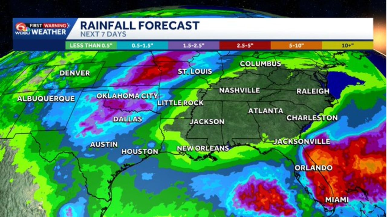
The latest data highlights a sharp divide in rainfall patterns, with most of the Southeast turning significantly drier, while one region stands out as an exception.
Widespread Dry Pattern Taking Over the Southeast
Forecast models show that large portions of the Southeast will receive little to no meaningful rainfall, including:
- Texas
- Louisiana
- Mississippi
- Alabama
- Georgia
These areas are already experiencing ongoing drought conditions, and the lack of incoming rain is expected to intensify dryness over the coming days.
Drought Conditions Expected to Worsen
The biggest concern is not just the current dryness, but what comes next:
- Minimal rainfall opportunities for 7 to 10+ days
- Increasing soil moisture loss
- Higher risk of expanding drought zones
With no consistent storm systems moving through, the region is entering a period where conditions can deteriorate rapidly.
Florida Stands Out as the Exception
While much of the Southeast dries out, Central and South Florida will see a completely different setup.
- Orlando, Miami, and surrounding areas are expected to receive heavy and beneficial rainfall
- Some areas could see several inches of rain over the next week
This rainfall could help ease drought conditions locally, even as nearby states continue to dry out.
Sharp Contrast Across the Region
The forecast creates a clear split across the Southeast:
- Dry and worsening drought → Gulf Coast and Deep South
- Wet and stormy → Florida peninsula
This contrast is being driven by storm tracks staying south and east, allowing moisture to focus over Florida while bypassing inland Gulf states.
Why This Pattern Matters
This developing pattern is critical because:
- It extends over multiple days, not just a short-term dry spell
- It impacts key agricultural and water resource regions
- It follows an already dry start to the season in many areas
Without incoming rain, even areas not currently in severe drought could quickly begin to see impacts.
Areas Most at Risk
The highest concern zones include:
- Central and South Texas
- Southern Louisiana
- Mississippi and Alabama
- Interior parts of Georgia
These areas are most likely to experience continued drying and worsening drought conditions.
What Residents Should Expect
As this pattern settles in:
- Warmer and drier conditions will dominate
- Limited cloud cover and rainfall chances
- Increasing stress on vegetation, agriculture, and water supplies
Meanwhile, Florida residents should prepare for the opposite scenario — frequent rain and possible localized flooding.
Situation to Watch Closely
This evolving weather pattern across the Southeast represents a significant shift toward dryness, with impacts that could build over time if rain continues to stay away.
The contrast between dry Gulf states and wet Florida makes this one of the more notable regional weather setups of the week.
Stay with WaldronNews.com for continued updates as this Southeast drought situation develops and conditions evolve over the coming days.