
Southeast Winter Storm Could Dump 4–8 Inches of Snow Across the Carolinas as Arkansas Watches the Southern Edge
WALDRON, ARKANSAS — A strengthening winter storm expected to develop late Friday into the weekend is drawing growing attention across the Southeast and Mid-Atlantic, with heavy snow likely for parts of the Carolinas and lighter impacts possible on the western fringe of the system, including portions of the Deep South. While Arkansas is not expected to see major snowfall from this system, forecasters say residents should still monitor the storm’s evolution as the southern snow shield takes shape.
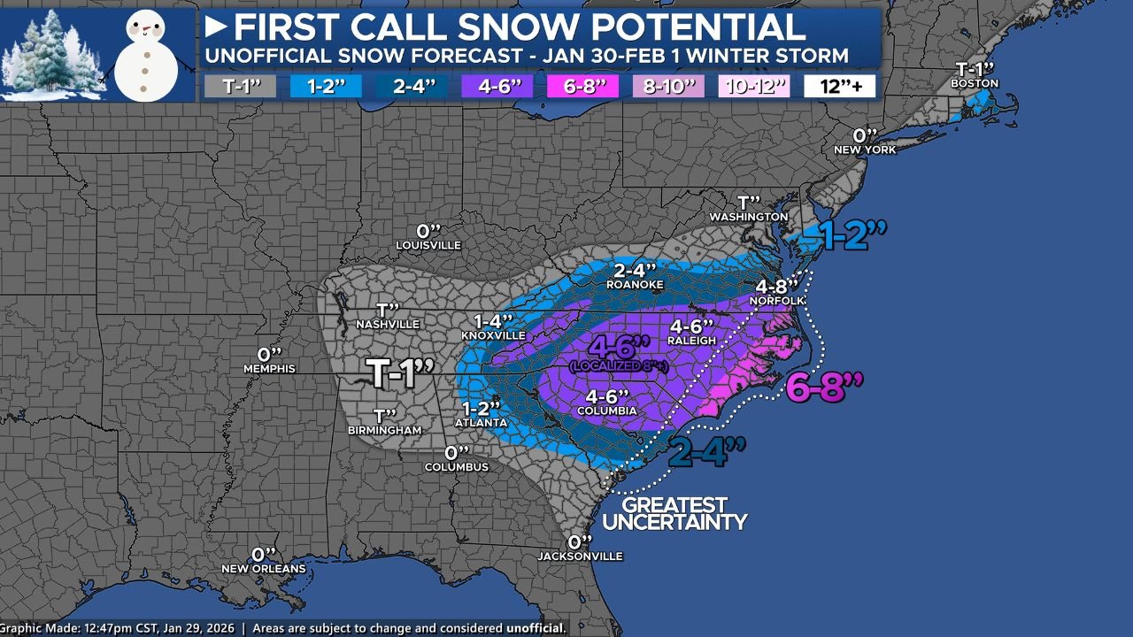
Early, unofficial snowfall projections show a broad swath of accumulating snow from northern Georgia through the Carolinas and into the Smoky Mountains, with totals increasing closer to the coast. The storm is expected to intensify as a surface low develops and tracks near or offshore of the Southeast coast late Saturday into Sunday.
Snowfall Totals Could Climb Rapidly in the Carolinas
Forecast guidance indicates that much of central and eastern North Carolina, along with parts of South Carolina, could see 4 to 6 inches of snow, while localized areas may exceed 8 inches if the storm strengthens closer to the coast. The heaviest snowfall potential currently appears centered from inland South Carolina through central North Carolina and toward the Outer Banks.
Farther east, parts of eastern North Carolina — including sections of the Outer Banks — are currently projected to fall in the 6 to 8 inch range, though forecasters stress that uncertainty remains high. A slight shift in the storm’s track could significantly increase or decrease totals in coastal zones.
Storm Track Will Determine Final Impacts
Meteorologists caution that the exact placement of the surface low is still uncertain, which is common with developing winter storms at this range. If the low tracks farther offshore, snow totals across the Southeast could trend lower. However, a closer coastal track would enhance moisture and lift, increasing snowfall totals and expanding heavier snow bands inland.
Another key factor is the presence of dry air, which could cut down on snow amounts in some areas if it intrudes into the system during peak precipitation.
Lighter Snow Possible on the Western Edge of the System
Outside the core snow zone, light snow or flurries may extend westward into parts of Alabama, Tennessee, and Kentucky, especially near the southern Appalachians. Arkansas currently sits west of the main impact zone, but forecasters note that fringe systems like this can still bring brief cold air surges, gusty winds, or light precipitation depending on how the storm evolves.
At this time, no significant snowfall is expected for Arkansas, including Scott County, but the system remains under close observation due to its size and strength.
Snow Ratios Could Boost Totals in Colder Areas
One notable element of this forecast is higher snow-to-liquid ratios, particularly across the Carolinas. Instead of the standard 10:1 ratio, some areas may see ratios closer to 15:1, meaning lighter, fluffier snow that can accumulate more quickly than models initially suggest.
Forecasters emphasize that snowfall totals could still change — either higher or lower — depending on the final storm track, thermal profiles, and exact snow ratios.
What Arkansas Residents Should Know
For now, Arkansas residents should view this storm as a major Southeast and Mid-Atlantic winter weather event, rather than a direct local threat. Still, colder air pushing south behind the system could reinforce winter conditions across the region late this weekend.
Residents are encouraged to stay weather-aware, especially if travel plans include the Southeast or East Coast during the Saturday-to-Sunday timeframe.
WaldronNews will continue monitoring forecast updates and will provide local coverage if conditions change or impacts shift farther west. Stay tuned for the latest winter weather developments.