
Southern California Braces for Potential Santa Ana Windstorm as Powerful Trough Dives Through the Great Basin — Fire Danger Remains Extremely Low
CALIFORNIA — A strengthening upper-level trough diving south through the Great Basin could set the stage for a notable Santa Ana wind event in Southern California roughly seven days from now, according to the latest long-range model guidance.
The projected setup shows a pronounced dip in the jet stream carving into California and Nevada, with strong upper-level energy rotating along the West Coast before sweeping inland.
What the Latest Model Data Shows
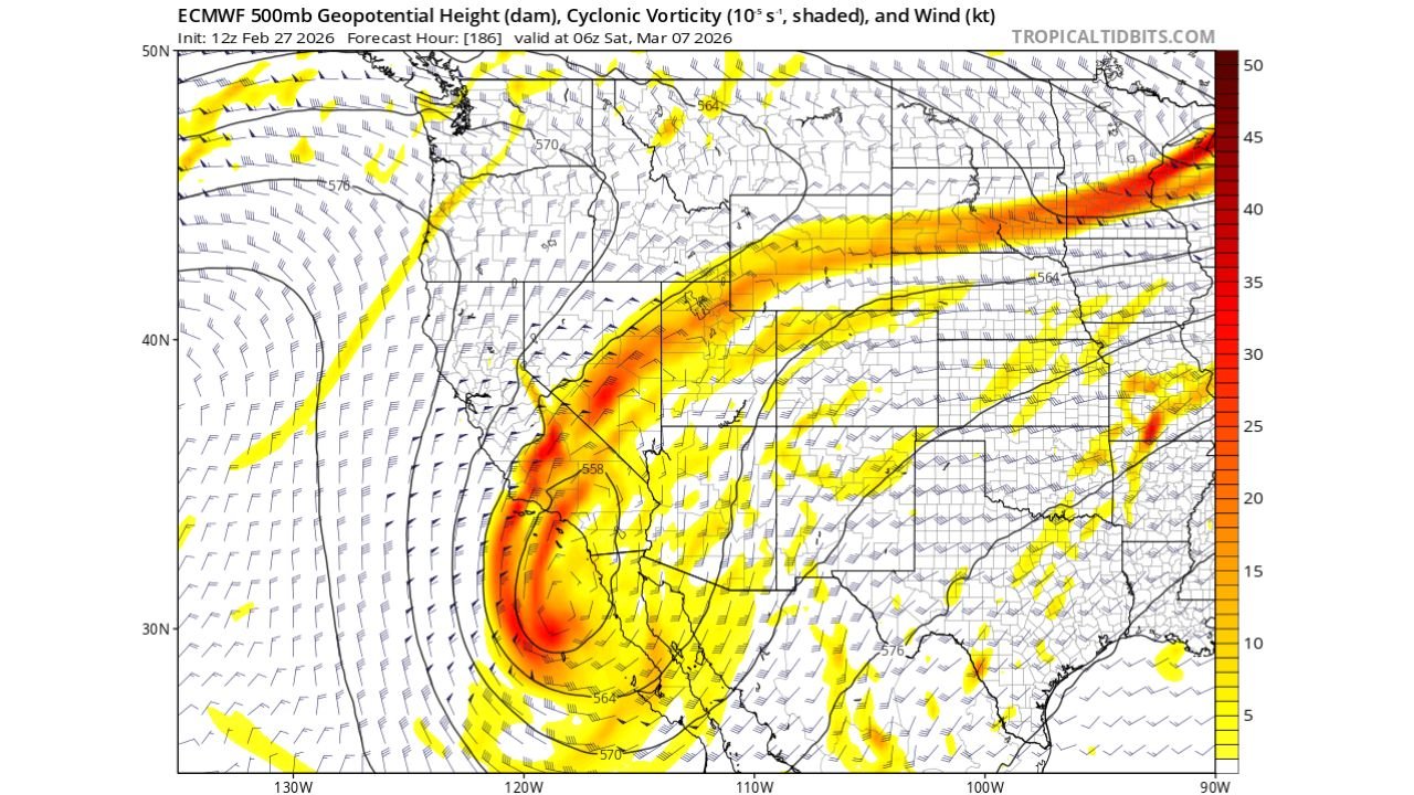
The ECMWF 500mb forecast valid early March highlights:
- A deep trough digging south along the West Coast.
- Strong cyclonic vorticity concentrated near Southern California.
- A powerful jet streak arcing from California across the Rockies and into the central United States.
- Tight height gradients across Nevada, Arizona, and Southern California — a classic Santa Ana signal.
This pattern supports strong offshore flow potential as high pressure builds inland while lower pressure develops offshore.
Why This Could Trigger Santa Ana Winds
Santa Ana winds typically develop when:
- A trough passes east of California.
- Surface high pressure strengthens over the Great Basin.
- Air accelerates downslope toward the Southern California coast.
The projected trough diving through Nevada and Utah would create that inland high-pressure response, potentially driving northeast winds into Los Angeles, Orange County, San Diego County, and surrounding valleys.
The jet structure also suggests strong upper-level support, which can enhance wind speeds at the surface if the pressure gradient tightens sufficiently.
A Key Difference From January’s Event
Unlike the January 7, 2025 wind event, this setup follows a notably wetter winter pattern.
That matters significantly.
Recent precipitation has reduced fuel dryness across much of Southern California, keeping fire danger classified as extremely low at this time. Even if strong winds materialize, the risk profile would be far lower than during peak dry-season Santa Ana outbreaks.
Timing and Confidence
The model image is valid around March 7, indicating this is still a medium-range forecast scenario.
While the trough placement is consistent with Santa Ana development, several factors could still shift:
- Exact strength and orientation of the trough.
- Magnitude of surface high pressure over the Great Basin.
- How quickly the jet retracts or shifts east.
At this lead time, the signal is noteworthy but not locked in.
Broader National Pattern
Beyond California, the jet stream arcs sharply from the Southwest across the central Plains and into the Midwest, suggesting:
- Active weather potential downstream.
- Strong upper-level energy transporting across the Rockies.
- Possible storm development in the central U.S. following the West Coast trough.
But for Southern California, the primary concern remains wind potential rather than precipitation.
What Residents Should Watch
If the trough maintains its strength in upcoming model runs, Southern California could see:
- Gusty northeast winds in mountain passes and coastal foothills.
- Elevated but still low fire risk due to recent moisture.
- Dry, warm conditions typical of Santa Ana setups.
For now, this remains a developing situation roughly one week out.
Stay with WaldronNews.com as we continue tracking this potential wind event and provide updates as forecast confidence increases.