
Southern California Set for First Rain in Over a Month as Cooler Pattern Replaces Heat Across Entire State Next Week
SOUTHERN CALIFORNIA — A major shift in weather conditions is expected to unfold across California next week, bringing an end to the recent stretch of unseasonably warm temperatures and introducing the first meaningful chance of rain in over a month for Southern California.
After several days of above-normal warmth continuing through the upcoming weekend, forecasters indicate that a cooler, more active weather pattern will take hold beginning early next week, with rain chances increasing between Tuesday, March 31 and Thursday, April 2.
First Rain Since February Likely for Southern California
One of the most notable aspects of this developing pattern is the potential return of measurable rainfall to Southern California, where dry conditions have persisted for weeks.
According to the outlook, February 19 was the last time many Southern California locations recorded measurable rain, meaning this upcoming system could break a month-long dry streak.
While exact rainfall totals remain uncertain, the setup suggests at least some level of precipitation will reach much of the region, marking a significant change from recent conditions.
Cooler Temperatures and Increasing Clouds Expected
Along with the rain chances, temperatures across Southern California are expected to drop noticeably as onshore flow strengthens.
This shift will bring:
- Increasing cloud cover across coastal and inland areas
- Gradually cooling daytime temperatures
- A transition away from the recent warm-to-hot conditions
The cooler air mass will spread across much of California, signaling a broader statewide pattern change rather than a localized event.
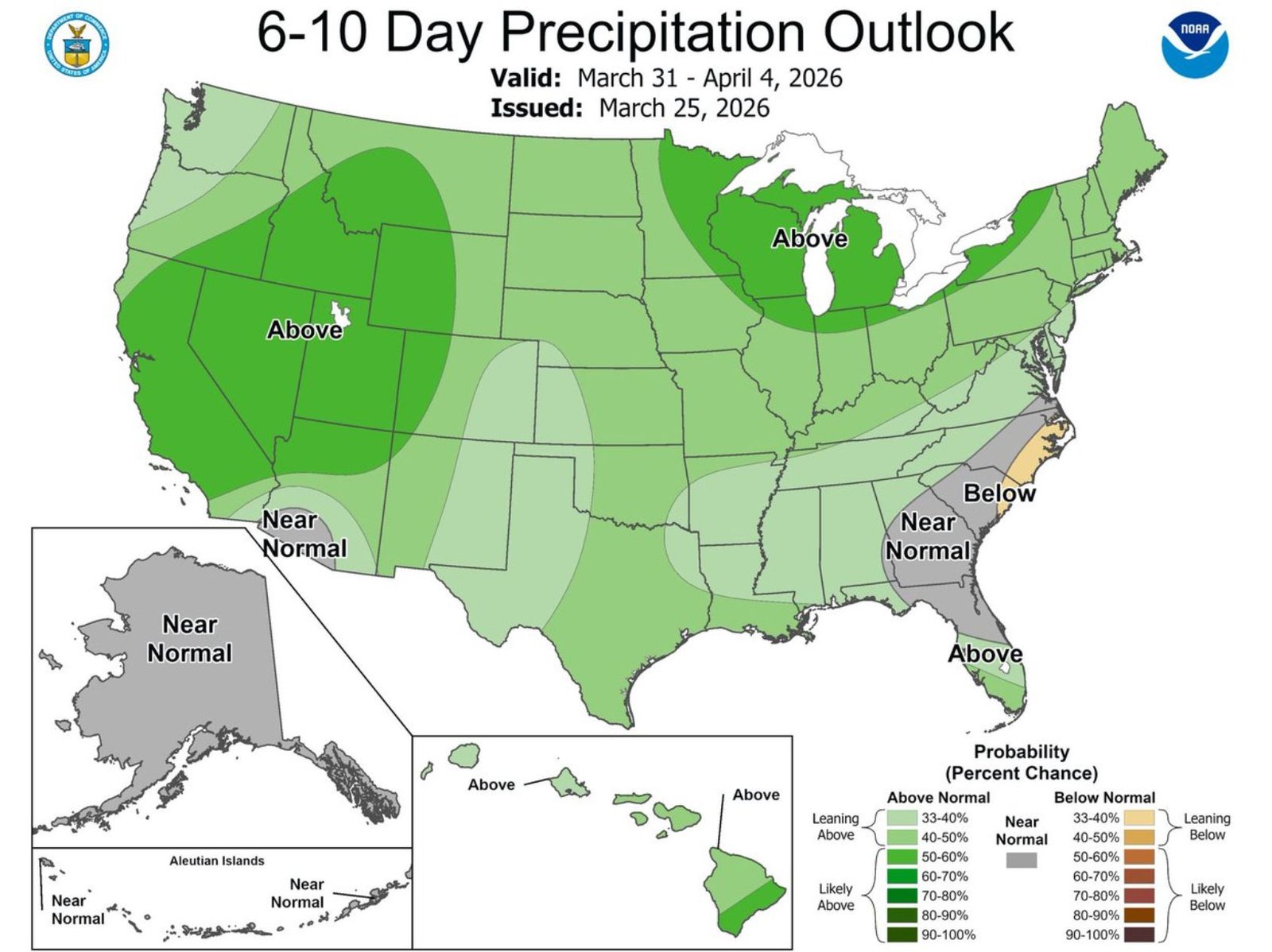
Above-Average Rainfall Signal Covers All of California
Looking at the broader outlook for March 31 through April 4, forecast guidance shows a strong signal for above-average precipitation across nearly all of California.
This includes:
- Northern California and coastal regions
- Central Valley and interior valleys
- Southern California, including Los Angeles and San Diego areas
The widespread nature of this signal indicates that multiple systems or a sustained moisture pattern could impact the state during this period.
Pattern Shift Extends Beyond California
The same outlook also highlights increased precipitation chances across parts of the Great Lakes and portions of the western United States, reinforcing the idea of a large-scale atmospheric shift.
Meanwhile, some areas of the Southeast and Mid-Atlantic are expected to remain closer to or below normal in terms of precipitation during this timeframe.
What to Watch in the Coming Days
Although confidence is growing in a wetter and cooler pattern, key details are still being refined, including:
- Exact timing of rain arrival in Southern California
- Rainfall intensity and duration
- Potential for multiple rounds of precipitation
Residents should stay updated as forecasts become more precise, especially as the system approaches early next week.
For now, the message is clear: a long-awaited change is coming, with cooler temperatures and the first meaningful rain chances in weeks set to impact Southern California and much of the state.
Waldron News will continue tracking this evolving weather pattern and provide updates as more details become available.