
Southern Illinois and Southern Indiana Under Tornado Risk While Northern Illinois, Indiana and Ohio Brace for Large Hail Today
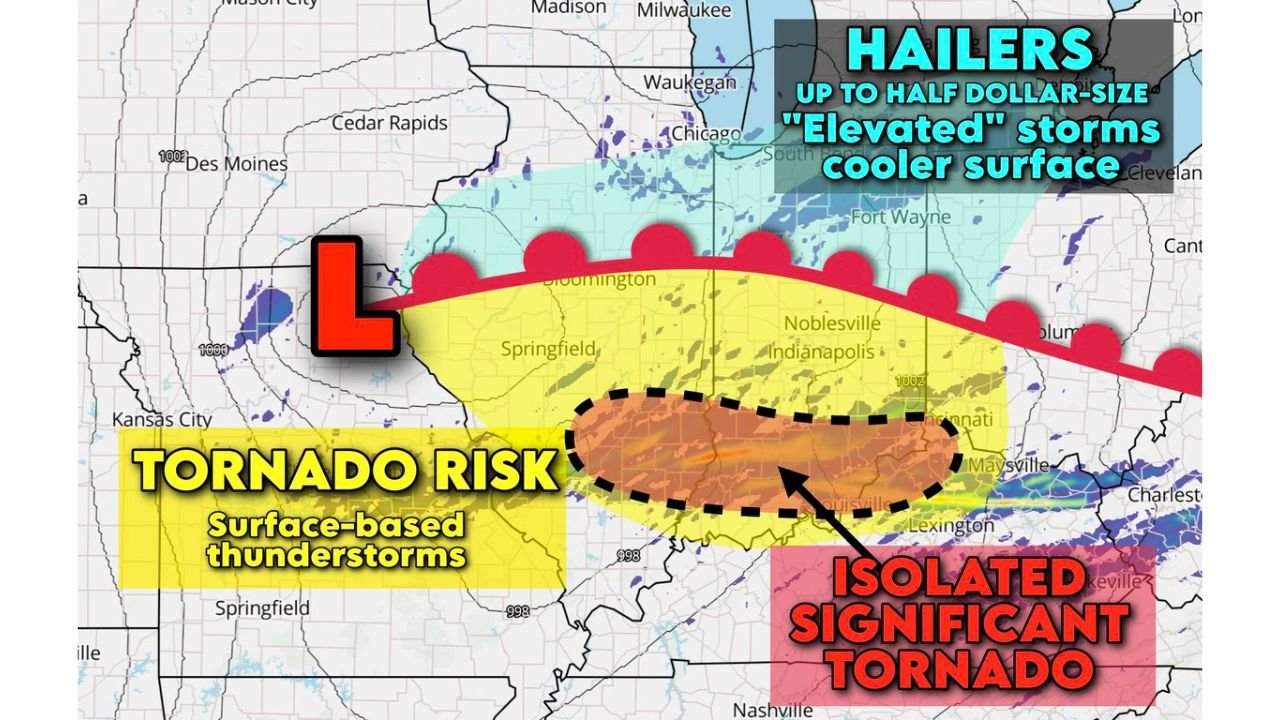
ILLINOIS, INDIANA AND OHIO — A split severe weather setup is unfolding across the Midwest today, with northern Illinois, northern Indiana and much of Ohio facing a hail threat, while southern Illinois and southern Indiana sit in a corridor where a tornado — potentially significant — cannot be ruled out.
Forecasters say the key dividing line will be a warm front draped west to east across the region, separating cooler surface air to the north from warmer, more humid air to the south.
North of the Warm Front: Elevated Hailers
Across northern Illinois, including Chicago and areas near Waukegan, extending east into northern Indiana and much of Ohio, storms are expected to remain “elevated.”
That means thunderstorms will ride above a shallow layer of cooler surface air, limiting tornado potential but increasing the risk for:
- Hail up to half-dollar size
- Gusty winds
- Frequent lightning
These elevated storms develop along and north of the warm front and are fueled by strong winds aloft rather than surface-based instability.
Cities in the hail zone include:
- Chicago, IL
- Rockford, IL
- Fort Wayne, IN
- Cleveland, OH
- Columbus, OH
While tornado risk is lower here, hail damage to vehicles and roofs remains possible.
South of the Boundary: Surface-Based Storms and Tornado Concern
The more concerning setup exists across southern Illinois into southern Indiana, where warmer and more humid air will allow storms to become surface-based.
This region includes areas near:
- Springfield, IL
- Bloomington, IN
- Evansville, IN
- Terre Haute, IN
- Louisville, KY (near the boundary zone)
Along this corridor, a moisture boundary is expected to enhance low-level helicity — or atmospheric spin — increasing the potential for rotating supercells.
Forecasters note that this is the zone where a storm could “gobble up” that spin and produce:
- A tornado
- Possibly an isolated significant tornado (EF2+)
The highest concern appears centered from south-central Illinois into southern Indiana, where the overlap of moisture, shear, and instability is strongest.
Why the Setup Is Split
The difference between hail-only storms and tornado-producing storms will come down to temperature and moisture at the surface.
North of the warm front:
- Cooler surface air
- Storms elevated
- Primarily hail threat
South of the warm front:
- Warmer, humid air
- Surface-based supercells
- Tornado risk increases
This type of boundary-driven setup often produces sharp contrasts in impacts over relatively short distances.
Timing and What to Watch
Storms are expected to develop and intensify this afternoon and evening as the system tracks eastward.
Residents in southern Illinois and southern Indiana should:
- Monitor for tornado watches and warnings
- Have multiple ways to receive alerts
- Be prepared to move to a safe interior room if warnings are issued
Those in northern Illinois, Indiana and Ohio should remain alert for strong storms capable of damaging hail.
Bottom Line
Today’s Midwest severe threat is not uniform. Northern Illinois, Indiana and Ohio are looking at elevated hail-producing storms, while southern Illinois and southern Indiana carry the greatest tornado concern — including the possibility of an isolated significant tornado if storms tap into enhanced low-level spin.
Conditions will evolve quickly, and even small shifts in the warm front could adjust the highest-risk corridor.
WaldronNews.com will continue tracking developments and provide updates as watches and warnings are issued.