
Southern Kentucky Faces Pop-Up Thunderstorms and Downburst Winds Wednesday Afternoon as Storms Develop Along and South of I-64 From 3 PM to 8 PM
LOUISVILLE, KENTUCKY — A weak atmospheric boundary is setting the stage for afternoon pop-up thunderstorms across Kentucky on Wednesday, with the primary threat window running from 3 PM to 8 PM for communities south of Interstate 64. While this is not expected to be a widespread, organized severe weather outbreak, the HRRR model is depicting the storm threat clearly — and the atmospheric sounding profile for the region shows conditions capable of producing downburst winds strong enough to trigger a couple of severe thunderstorm warnings during the afternoon and evening hours. For most of Kentucky, Wednesday will be primarily a heavy rain and lightning event — but residents south of I-64 should be aware that a few storms could pack a punch.
Who Needs to Pay Attention Wednesday
The storm setup Wednesday is geography-dependent in a very specific way:
Along the I-64 corridor: Communities along Interstate 64 — running from Louisville eastward through Frankfort, Lexington and Richmond — sit directly on the boundary where a weak atmospheric front could spark the first storms of the afternoon. This corridor is where thunderstorm initiation is most likely as surface heating kicks in after noon Wednesday.
South of I-64 — highest risk: The area south of Interstate 64 is where the atmosphere destabilizes most significantly during the afternoon hours. This includes communities across south-central and southeastern Kentucky — areas like Elizabethtown, Bowling Green, Somerset, London, Corbin and Middlesboro. As the sun heats the surface through the afternoon, the atmosphere becomes increasingly unstable in this zone, fueling the development of pop-up style thunderstorms that can quickly become intense. The 3 PM to 8 PM window is when this destabilization is most pronounced and storm activity most likely.
North of I-64: Communities north of Interstate 64 — including Louisville, Covington and northern Kentucky — face a lower threat Wednesday. While scattered storms are possible, the primary destabilization and storm development is expected to stay south of the interstate.
What to Expect From Wednesday’s Storms
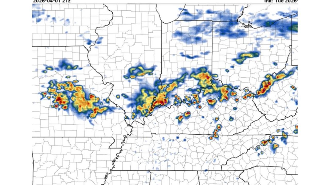
The HRRR model radar simulation for Wednesday April 1 at 9 PM shows a line of storm cells stretching across Kentucky — with intense red and yellow cores indicating the strongest rainfall rates — tracking from southwestern Kentucky through the central and eastern portions of the state. This is consistent with a pattern of pop-up storms organizing along a boundary and then spreading eastward through the afternoon.
The primary hazards for Wednesday are:
- Heavy rain — the most widespread impact across Kentucky. Localized rainfall totals could be significant in any storm cell that stalls or moves slowly
- Lightning — frequent lightning is expected with any thunderstorm that develops, making outdoor activity risky during the 3 PM to 8 PM window
- Downburst winds — the atmospheric sounding profile for central Kentucky on Wednesday afternoon shows a configuration capable of producing downburst winds — powerful downdrafts that hit the ground and spread outward, capable of snapping tree limbs, downing power lines and causing property damage. A couple of severe thunderstorm warnings are possible if the strongest cells produce winds above 58 mph
- Small hail — possible in the strongest individual storm cells
What the Atmospheric Profile Shows
The HRRR sounding analysis for Wednesday April 1 at 9 PM local — centered near 37.6°N, 85.5°W in central Kentucky — shows a CAPE of 2,284 J/kg with a maximum of 82°F at the surface. This is a meaningful amount of instability for early April in Kentucky, enough to fuel intense thunderstorm updrafts during the afternoon.
The WNDG (Wind Damage) parameter of 5.7 m²/s² — a measure of the potential for damaging wind events — supports the downburst concern highlighted in the forecast. The profile is classified as Marginal SVR in the SARS analog database — confirming that while this is not a major severe weather outbreak, the strongest storms Wednesday could reach severe criteria.
The critical angle of 91 and moderate shear values indicate that storms will have some organizational tendency, but the overall setup favors a heavy rain and wind event rather than a tornado-producing environment.
Timing Your Day Around Wednesday’s Storms
For residents across south-central and southeastern Kentucky, planning around the 3 PM to 8 PM storm window is straightforward:
- Morning and early afternoon — conditions are fine for outdoor activity. Get outdoor tasks done before 3 PM if possible
- 3 PM to 8 PM — the primary storm window. Outdoor activities, evening commutes and outdoor events should be monitored closely. Have a plan to move indoors quickly if lightning or heavy rain begins
- After 8 PM — conditions are expected to gradually improve as the afternoon heating cycle ends and storm activity diminishes
What to Watch Next
- Wednesday afternoon boundary activation — whether the weak front along I-64 successfully sparks storm initiation in the early afternoon or storms hold off until later in the day
- Storm cell intensity — which individual cells become strong enough to produce severe thunderstorm warnings for downburst winds
- Rainfall totals — whether any slow-moving cells drop particularly heavy rain over south-central Kentucky communities
- Evening clearing — whether conditions improve ahead of schedule or storms linger past 8 PM across eastern Kentucky
Residents across Elizabethtown, Bowling Green, Somerset, London and Corbin should keep an eye on the sky from 3 PM onward Wednesday, have weather alerts enabled on mobile devices and avoid outdoor activities during any periods of active lightning and heavy rain.
WaldronNews.com will continue monitoring Wednesday’s storm threat across Kentucky and provide updates if any severe thunderstorm warnings are issued during the afternoon and evening hours.