
Southern U.S. Storm System Targets Texas, Oklahoma, Arkansas, Louisiana, Mississippi and Alabama With 2–4 Inches of Rain and Flash Flood Threat Through Sunday
UNITED STATES — A widespread storm system sweeping across the southern United States from Friday through the weekend is expected to bring a broad swath of heavy rainfall, with several states facing the risk of localized flash flooding through early Monday morning.
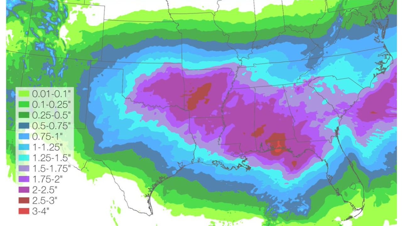
According to the latest National Weather Service rainfall outlook, the heaviest totals are projected from central and eastern Texas across Oklahoma and Arkansas into northern Louisiana, Mississippi, and Alabama, with some pockets possibly exceeding 3 to 4 inches of rainfall.
Heaviest Rainfall Focused Over Texas to the Deep South
The rainfall forecast map shows a large zone of 2 to 3 inches stretching from:
- Central and eastern Texas
- Much of Oklahoma
- Western and central Arkansas
- Northern and central Louisiana
- Large portions of Mississippi
- Parts of Alabama
Embedded within this zone are isolated areas — particularly in parts of Louisiana, Mississippi, and eastern Texas — where totals could climb into the 3 to 4 inch range.
This concentrated band of heavy rain suggests repeated rounds of showers and thunderstorms tracking over the same areas, increasing the risk of runoff issues.
Flash Flooding Risk Growing in Low-Lying Areas
With rainfall expected to fall steadily from Friday morning through Sunday night, localized flash flooding may develop in:
- Urban corridors
- Poor drainage zones
- Creeks and small streams
- Areas that have recently seen wet conditions
The prolonged nature of this rainfall event means soils may become saturated quickly, especially across Louisiana and Mississippi, where the highest totals are indicated.
While widespread river flooding is not specifically outlined in this forecast graphic, short-term flooding of roads and low-lying areas cannot be ruled out where heavier downpours repeatedly develop.
Moderate Rain Extends Into Southeast and Mid-South
Surrounding the core heavy rainfall zone, lighter but still steady rainfall of 1 to 2 inches is expected across:
- Eastern Alabama
- Georgia
- Western Tennessee
- Portions of the Florida Panhandle
- Southern Missouri
Meanwhile, rainfall totals taper off to under an inch across the Mid-Atlantic and parts of the Midwest, though periods of rain may still occur.
System Spanning From Southwest to East Coast
The broader storm system stretches from the Southwest into the Southeast. While lighter precipitation is expected in parts of the Southwest and central Plains, the most organized and impactful rainfall appears concentrated across the southern tier of states.
Forecast totals are valid from Friday morning through Monday morning, indicating this will be a multi-day rainfall event rather than a quick-moving system.
What Residents Should Watch For
Residents across the southern states in the heavier rainfall zone should monitor:
- Rapid ponding on roads
- Temporary street flooding
- Water rises in small streams
- Travel disruptions during heavier downpours
Those living in flood-prone areas should stay alert for any updated advisories or warnings from local National Weather Service offices.
The combination of persistent rainfall and localized heavier bursts could create isolated flash flooding situations, especially during peak rainfall periods over the weekend.
Waldronnews.com will continue monitoring updated rainfall projections and any developing flood concerns across the southern United States.