
Southern U.S. Weather Models Show Wild Swings: Alabama, Georgia, Mississippi, and Tennessee Could See 40° Temperature Drop in Mid-December
Birmingham, Alabama — Meteorologists across the South are warning of major model volatility ahead of a potential mid-December cold outbreak, as forecast data shifts between warm and freezing conditions across Alabama, Georgia, Mississippi, and Tennessee. The latest guidance suggests that a sharp Arctic boundary could drop temperatures by as much as 40 degrees in parts of the region.
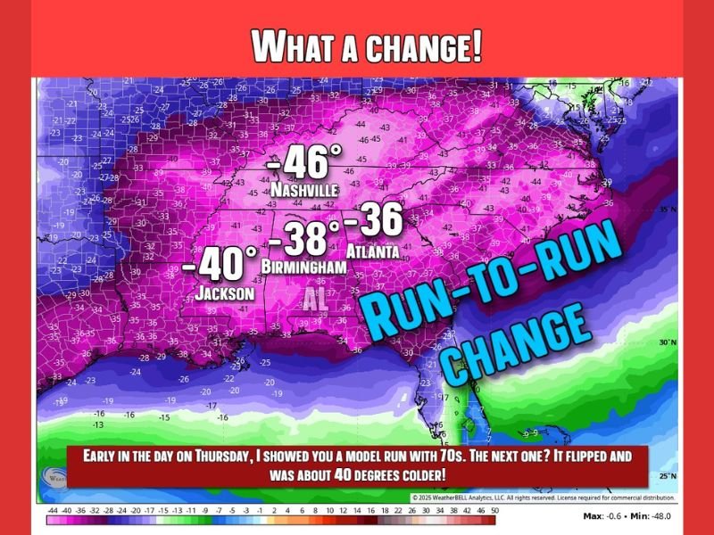
Forecast Models Flip from 70s to Deep Freeze
Just days ago, several model runs projected unseasonably warm weather with highs in the upper 60s and low 70s around December 18–19. But newer runs now show the opposite — a powerful Arctic cold front driving temperatures down by more than 30–45°F across the southern and southeastern United States.
Forecasters say this kind of dramatic shift is a sign of a volatile weather pattern, with boundaries forming between warm Gulf air and incoming Arctic air masses. These setups are well-known for rapid model changes and unpredictable outcomes.
“This isn’t junk forecasting — it’s volatility,” one forecaster explained. “The models are excellent tools, but when atmospheric energy is this unstable, even small changes in timing can mean a swing from a spring-like day to an icy blast.”
Potential Impacts Across the South
If the colder trends verify, areas like Jackson (MS), Birmingham (AL), Atlanta (GA), and Nashville (TN) could experience one of the sharpest temperature drops of the season. The latest projections show highs potentially plunging from the upper 60s into the mid-20s within a day’s time.
Along the leading edge of this system, rain and thunderstorms are also possible, followed by much colder, windy conditions across the South. While it’s too early to determine if wintry precipitation will develop, forecasters note that the strong contrast between air masses could produce severe weather in parts of the Gulf region.
Why the Models Are So Unstable
Weather experts emphasize that long-range models are not unreliable — rather, they are reflecting a highly dynamic atmosphere. “These swings show how much energy is building up in the system,” said one meteorologist. “It’s like trying to predict which direction a spring will snap.”
Such volatility makes forecasting beyond five days challenging. A single model run may show 70°F warmth one morning and sub-freezing conditions by the next — a sign of competing air masses and fast-moving jet stream changes.
Stay Alert for Rapid Forecast Changes
Forecasters caution residents in the Deep South and Southeast to expect rapid forecast changes over the next week. “A simple rainy day could evolve into a severe weather setup — or fade away completely,” one meteorologist said.
While confidence remains low in exact details, most meteorologists agree that the pattern is turning colder and more active heading into the final week before Christmas.
For updated regional forecasts and storm outlooks, follow WaldronNews.com for verified weather coverage across Alabama, Georgia, Mississippi, and Tennessee.