
Southern Winter Storm Signal Emerges for Texas, Arkansas, Tennessee, and the Carolinas as Models Hint at Snow and Ice Next Weekend
UNITED STATES — Forecast models are increasingly highlighting the potential for a winter weather event across the southern United States next weekend, raising the possibility of snow and mixed precipitation from Texas into the Southeast, according to multiple recent runs of the ECMWF model.
The signal has appeared consistently across several model cycles, suggesting the pattern is worth monitoring even though details remain uncertain at this range.
ECMWF Shows Broad Winter Precipitation Swath
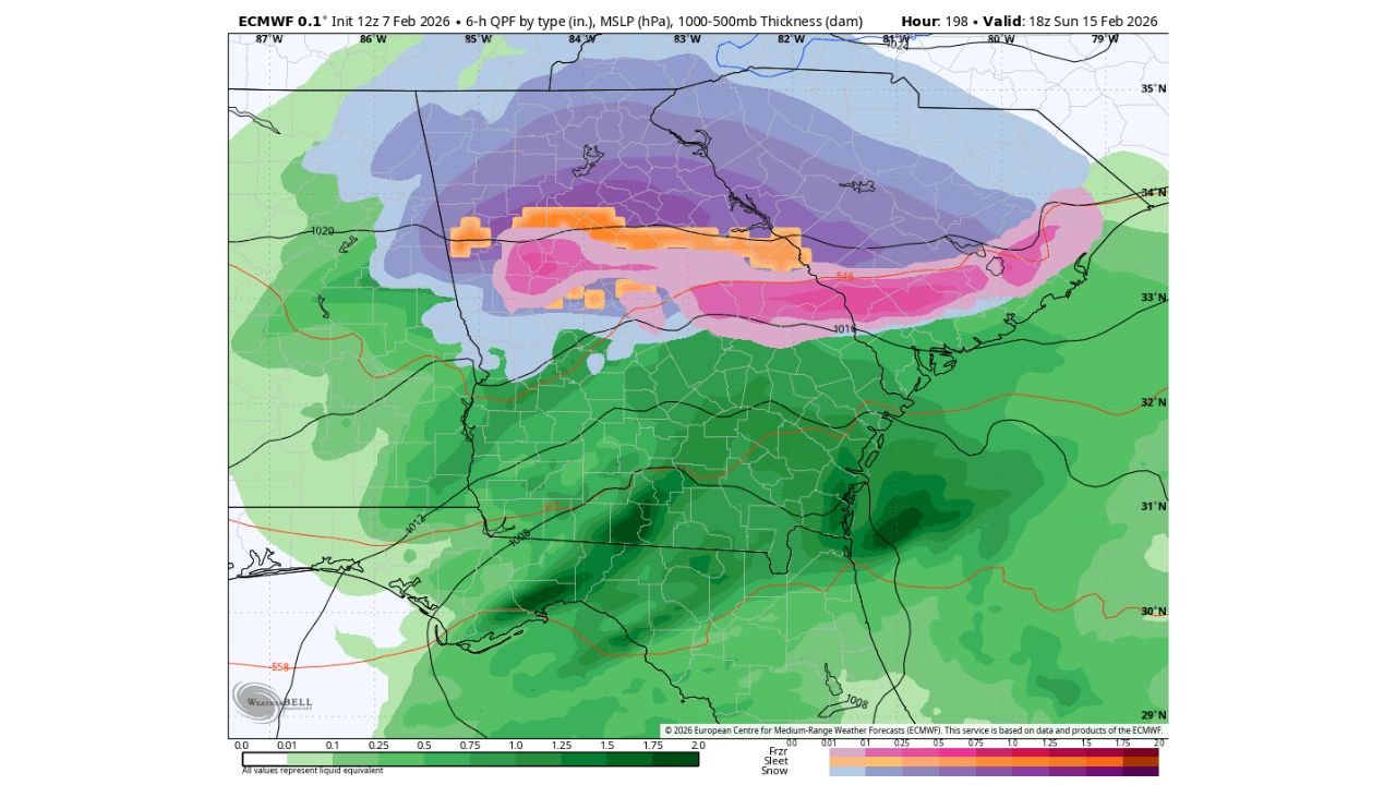
The ECMWF guidance valid for Sunday, February 15 depicts a wide band of winter precipitation stretching across parts of the South, with different precipitation types aligned north to south.
Based on the model output:
- Snow (purple shading) is indicated across portions of North Texas, Oklahoma, Arkansas, northern Mississippi, Tennessee, Kentucky, and into the southern Appalachians
- A mixed zone of sleet and freezing rain (pink and orange shading) appears farther south, including parts of Arkansas, Tennessee, northern Alabama, northern Georgia, South Carolina, and North Carolina
- Cold rain (green shading) dominates areas farther south, including southern Texas, Louisiana, Mississippi, Alabama, Georgia, and Florida
This setup places much of the southern tier in a classic transition zone, where small temperature changes could significantly impact precipitation type.
States Potentially Impacted by Winter Weather
If the model scenario verifies, states that could see winter precipitation next weekend include:
- Texas
- Oklahoma
- Arkansas
- Tennessee
- Kentucky
- Mississippi
- Alabama
- Georgia
- South Carolina
- North Carolina
The highest snow potential appears north of the freezing line, while areas closer to the Gulf Coast remain warm enough for rain.
Why Confidence Is Still Limited
While the winter signal has persisted for several model runs, forecasters caution that:
- The system remains several days away
- Track and temperature profiles are not yet locked in
- Small shifts could move the snow band north or south
At this stage, the guidance highlights potential, not certainty.
Why This Setup Matters
Southern winter storms often produce outsized impacts due to limited snow and ice infrastructure. Even modest snowfall or icing can lead to:
- Hazardous travel
- School and business disruptions
- Power outages if ice accumulates
The current model depiction suggests a large geographic footprint, increasing the number of communities that may need to prepare.
What to Watch Going Forward
Forecasters will be closely monitoring:
- Whether the winter precipitation signal remains consistent
- Changes in the rain–snow transition zone
- Temperature trends ahead of the system
More clarity is expected as the event moves into the short-range forecast window later this week.
WaldronNews.com will continue tracking this developing southern winter weather threat and provide updates as confidence increases and impacts become clearer.