
Strengthening -NAO Block and Western Montana Ridge Shift Raise Major Snowstorm Threat From Pennsylvania to New Jersey and New York Sunday Night Into Monday
NORTHEAST UNITED STATES — A notable shift in the upper-level pattern is increasing the potential for a more significant winter storm across the Northeast late this weekend. Updated ensemble guidance shows a stronger negative North Atlantic Oscillation (-NAO) block and a repositioned western ridge — a setup that is often favorable for impactful snow along the I-95 corridor.
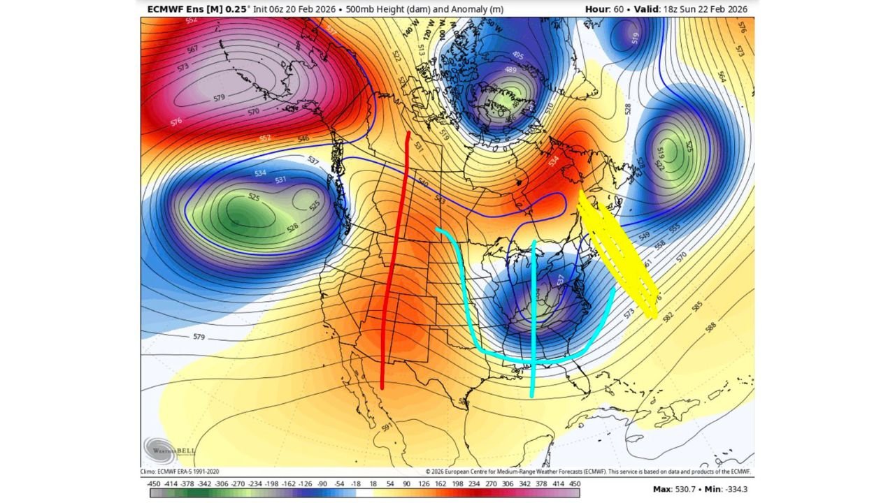
Forecasters say the change stems from a slight adjustment in the ridge, now expected to pump northward and stabilize over western Montana. That positioning can help funnel colder air into the eastern United States while slowing the storm’s forward motion — a combination that can support stronger coastal development.
-NAO Block Could Lock In the Storm Track
The 500mb height and anomaly map valid Sunday evening shows a pronounced blocking signal over the North Atlantic. This -NAO configuration can prevent storms from escaping quickly out to sea and instead encourage them to deepen closer to the East Coast.
At the same time, a trough digging into the southeastern United States — highlighted by the closed low near Georgia and the Carolinas — provides the energy necessary for cyclogenesis near the coastline.
When paired together, this block-and-trough alignment often favors larger, slower-moving snowstorms for:
- Pennsylvania
- New Jersey
- New York
- Connecticut
- Massachusetts
- Maryland and Delaware
- Northern Virginia
Inverted Trough Signal Over Pennsylvania
Forecasters continue to anticipate the development of an inverted trough somewhere across Pennsylvania, which could act as a focal point for enhanced snowfall rates.
Inverted troughs often produce persistent mesoscale banding, leading to localized snowfall maxima. Current projections suggest the highest odds for more substantial impacts may be along and east of the I-95 corridor — particularly from Philadelphia to New York City and into southern New England.
However, placement remains critical. A shift of even 50 miles could dramatically change where the heaviest snow bands settle.
Sunday Evening Into Monday: Prime Impact Window
The most likely timeframe for significant impacts appears to be Sunday evening through Monday. If the coastal low strengthens efficiently under the block, heavy precipitation could expand inland while colder air remains locked in place.
Areas along the coast — including New Jersey, eastern Pennsylvania, New York City, Long Island, and southern New England — currently appear to have the highest probability of major impacts based on ensemble trends.
Heavy, Wet Snow Could Increase Damage Risk
Another key detail emerging from the updated guidance is snow ratio expectations. Forecasters note that snowfall ratios may be on the lower side, favoring a heavy, wet snow rather than lighter, fluffier accumulations.
Heavy wet snow:
- Clings to trees and power lines
- Increases the risk of outages
- Makes road clearing more difficult
- Raises structural stress on flat roofs
In short, even moderate snowfall totals could produce outsized impacts if snow consistency is dense and moisture-laden.
Still Plenty to Track
While the upper-level pattern now looks more supportive of a larger event, final details — including storm intensity and exact track — remain subject to change.
Key questions over the next 24–36 hours include:
- Exact positioning of the inverted trough
- Coastal low strength and proximity to shore
- How tightly the -NAO block holds
- Rain/snow line placement near southern zones
Residents across Pennsylvania, New Jersey, New York, and surrounding states should closely monitor forecast updates as the weekend approaches.
Stay with Waldronnews.com for the latest developments as this evolving Northeast winter storm setup becomes clearer.