
Sunday Snow System Expected to Clip Cape Cod With Several Inches While Most of Massachusetts Sees Little to No Accumulation
UNITED STATES — A developing Sunday snow system is forecast to narrowly miss much of southern New England, with Cape Cod and the outer coastal areas expected to take the brunt of the snowfall, according to the latest regional snowfall outlook.
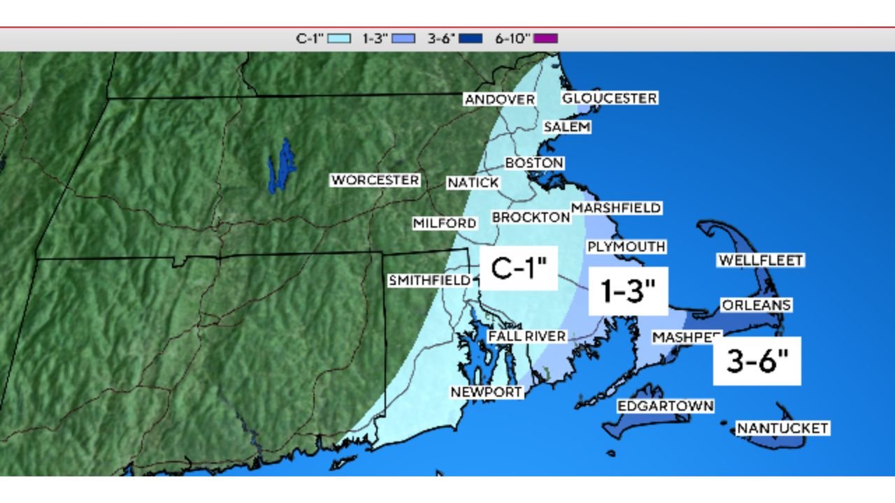
Forecast data shows the storm tracking just far enough offshore to spare most inland communities, while Cape Cod, the Islands, and immediate coastal sections receive measurable snow.
Cape Cod and Islands Face the Highest Snow Totals
Based on the snowfall forecast:
- Outer Cape Cod, including areas near Wellfleet, Orleans, and Nantucket, could see 3 to 6 inches of snow
- Plymouth County and the Mid-Cape are projected to receive 1 to 3 inches
- Martha’s Vineyard may also see several inches, depending on the storm’s exact track
These areas sit closest to the storm’s coastal snow band, where colder air and ocean-enhanced moisture overlap.
Boston and Most Inland Areas Likely Escape With Minimal Snow
The forecast sharply drops off just west of the coast:
- Boston, Natick, Brockton, Milford, and much of eastern Massachusetts are expected to see coating to 1 inch
- Central and western Massachusetts appear likely to see little to no snowfall
- Parts of Rhode Island, including Fall River and Newport, may see up to 1 inch, with higher totals closer to the shoreline
This tight gradient means a difference of just a few miles could determine whether snow accumulates or barely sticks.
Why the Storm Misses Most of the Region
Forecasters note that the storm’s track remains just offshore, keeping the heaviest snow band over the Atlantic rather than pushing inland.
Key factors include:
- Limited inland moisture penetration
- Cold air remaining shallow near the coast
- The storm’s strongest lift staying east of the mainland
This setup results in Cape Cod getting clipped, while the rest of the region narrowly escapes a broader snow event.
Travel Impacts Still Possible Along the Cape
Even though most areas avoid heavy snow, localized travel issues are still possible on the Cape and Islands:
- Slippery roads during snow bursts
- Reduced visibility at times
- Ferry and coastal travel disruptions depending on wind conditions
Drivers traveling toward the Cape on Sunday should remain alert to rapidly changing conditions.
What This Means for Arkansas
While Arkansas is not affected by this system, the forecast highlights a highly active East Coast winter pattern, where small shifts in storm track can lead to big differences in impact.
Such patterns can evolve quickly, and similar setups later in the season could still influence the South-Central U.S.
Stay with WaldronNews for continued winter weather coverage, forecast breakdowns, and updates on national weather patterns that could impact Arkansas next.