
Sunday Snowfall First Call: Washington, D.C. to Baltimore Braces for 1–3 Inches, With Higher 3–6 Inch Band Possible West Toward Hagerstown
MARYLAND AND WASHINGTON, D.C. — The first call snowfall forecast for Sunday has been issued, and forecasters are taking a conservative approach as uncertainty remains high. While computer models will continue to update through the 12z and 18z runs, early projections suggest light to moderate snow across much of central Maryland and the D.C. metro, with higher totals possible farther west.
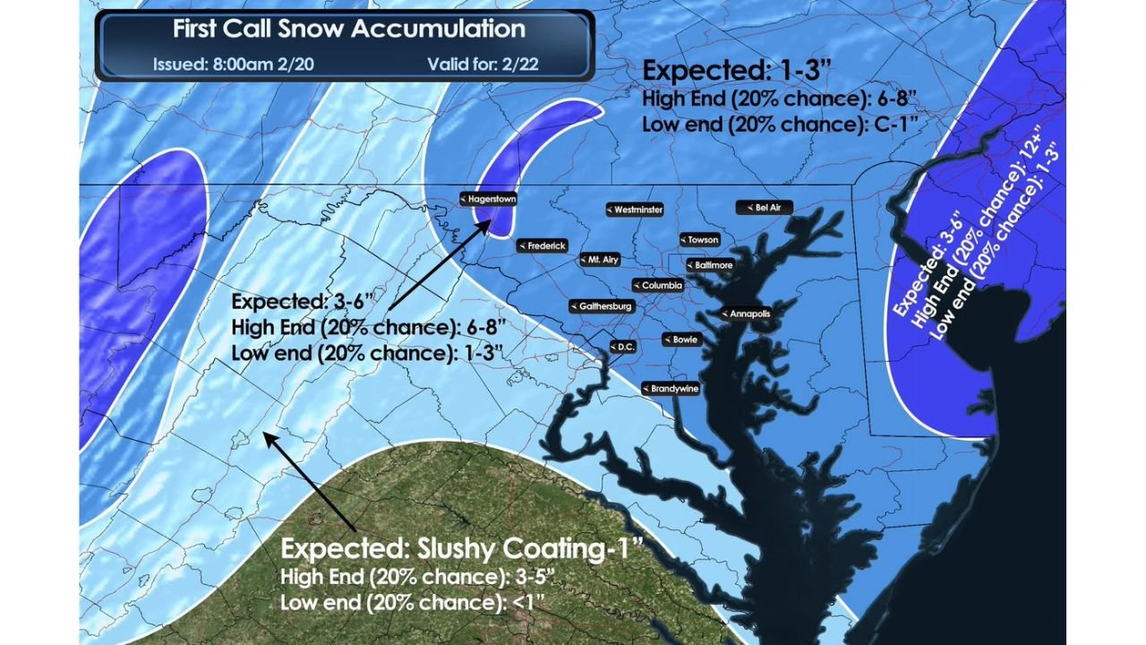
The forecast, issued at 8:00 a.m. on February 20 and valid for February 22, outlines a range of outcomes depending on how the storm ultimately develops.
D.C., Baltimore, Annapolis: 1–3 Inches Expected
For much of the I-95 corridor through Washington, D.C., Baltimore, Annapolis, Columbia, Towson, Bel Air, Bowie, Gaithersburg, and Westminster, the expected snowfall is currently:
- 1–3 inches
- High-end scenario (20% chance): 6–8 inches
- Low-end scenario (20% chance): coating to 1 inch
This places the metro areas in a zone where plowable snow is possible, but not guaranteed to reach disruptive levels unless the higher-end scenario materializes.
Western Maryland: 3–6 Inches With Upside Potential
Areas west and northwest of the metro region, including Frederick and Hagerstown, are projected to see slightly higher totals:
- 3–6 inches expected
- High-end (20% chance): 6–8 inches
- Low-end (20% chance): 1–3 inches
This heavier band aligns with stronger forcing to the west and could shift depending on storm track. If the system intensifies more than currently forecast, these areas could see solid moderate accumulations.
Southern Maryland and Lower Elevations: Slushy Coating to 1 Inch
Farther south into lower elevations, the forecast shows:
- Slushy coating to 1 inch
- High-end (20% chance): 3–5 inches
- Low-end (20% chance): Less than 1 inch
Warmer surface temperatures in these regions may limit accumulation unless snowfall rates increase significantly.
Why the Forecast Is Conservative
Forecasters stress that this is an early call and intentionally cautious. The exact track, phasing, and strengthening of the storm system remain uncertain. Small shifts east or west could dramatically change snowfall totals along the I-95 corridor.
If the system trends stronger or tracks slightly closer to the coast, totals could increase quickly across the D.C.–Baltimore corridor. Conversely, a weaker or more offshore solution would keep accumulations limited to lighter amounts.
What to Watch Next
Key model runs later today will help refine:
- Storm intensification speed
- Snow band placement
- Temperature profiles near the surface
- Potential expansion of higher snowfall totals
Residents across Washington, D.C., Baltimore, Frederick, Hagerstown, Annapolis, and surrounding communities should monitor updates closely through the day.
At this point, light to moderate snowfall appears most likely, but the door remains open for localized higher totals if conditions align.
Stay with Waldronnews.com for continuing updates as Sunday’s winter weather forecast becomes clearer.