
Supercell Surge Signal Emerging for Texas, Oklahoma, Louisiana and Arkansas as Mid-March 2026 Pattern Favors Early Severe Season Ramp-Up
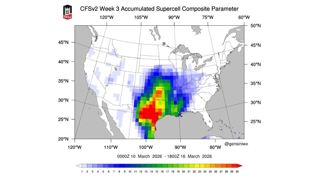
UNITED STATES — Long-range guidance is increasingly pointing toward a notable uptick in severe weather potential during the week of March 10–16, 2026, with the strongest signal centered across Texas, Oklahoma, Louisiana and Arkansas. The latest CFSv2 Week 3 Accumulated Supercell Composite Parameter highlights a concentrated corridor of elevated values stretching from the western Gulf Coast northward into the Southern Plains — a classic early spring severe weather zone.
The data suggests that the atmosphere could become increasingly supportive of organized thunderstorms, including supercells, as mid-March approaches.
Strongest Signal Centered Over Texas and the Southern Plains
The highest supercell composite values — shown in red and orange shading — are focused across:
- Central and eastern Texas
- Southern and central Oklahoma
- Western Louisiana
- Southern Arkansas
This corridor indicates an environment potentially supportive of sustained rotating thunderstorms during the March 10–16 timeframe.
The signal extends northward into:
- Kansas
- Missouri
And eastward into:
- Mississippi
- Alabama
While values weaken farther east, the broader pattern suggests a larger region of at least marginal severe support stretching across much of the lower Mississippi Valley and parts of the Southeast.
Gulf Moisture and Spring Instability Returning
The concentrated zone from south Texas into Oklahoma is especially notable because it aligns with typical early-season moisture return from the Gulf of Mexico.
In March, when upper-level troughing interacts with strengthening low-level moisture transport, it often produces:
- Enhanced wind shear
- Increasing instability
- Organized storm structures
- Elevated tornado and hail potential
The strongest composite signals hugging the Texas coastline and extending inland suggest that Gulf inflow could be a key ingredient during this period.
Expanding Risk into Arkansas, Louisiana and Mississippi
The composite parameter does not remain confined to Texas and Oklahoma. Moderate values extend eastward into:
- Arkansas
- Northern Louisiana
- Western Mississippi
This suggests that any storm systems ejecting from the Plains could continue to organize as they track eastward.
Even though long-range severe parameters do not guarantee specific outbreak days, they do reflect a pattern that is more favorable for organized convection than average.
Midwest Fringe Also Showing Early Signals
Lighter but still notable values extend into:
- Missouri
- Southern Illinois
- Western Kentucky
This indicates that the severe risk corridor may gradually expand northward depending on how the upper-level pattern evolves during mid-March.
If western troughing strengthens and ejects multiple disturbances into the Plains, the warm sector could push northward, opening the door for broader coverage of strong storms.
Why This Matters Heading Into Mid-March
The March 10–16 window marks a transitional period climatologically, when severe weather typically begins increasing across:
- Texas
- Oklahoma
- Louisiana
- Arkansas
The current long-range signal aligns closely with that seasonal ramp-up.
It is important to note that supercell composite guidance at this range does not pinpoint exact days or confirm tornado outbreaks. However, it does highlight an environment that could support organized severe storms if other ingredients align.
Residents across Texas, Oklahoma, Louisiana, Arkansas, Mississippi and neighboring states should remain aware that early spring volatility may increase as we move deeper into March.
Stay with WaldronNews.com for continued updates as this mid-March severe weather signal comes into sharper focus.