
Tennessee and Kentucky Brace for Overnight Severe Storms Early Monday With Damaging Winds and Possible Tornadoes Across the Plateau and Central Valley
TENNESSEE — Forecasters are warning that strong to severe thunderstorms could move across parts of Tennessee and Kentucky early Monday morning, bringing the potential for damaging winds exceeding 60 mph and isolated tornadoes during the overnight hours.
Meteorologists say the severe weather threat will be fueled by a powerful jet stream and a strong wind shear environment, which can allow storms to organize quickly even during nighttime hours.
The highest concern appears to be across Tennessee’s Plateau region and the Central Valley, where atmospheric conditions may support more intense storm development.
Storms Expected to Move Through Between 2 AM and 8 AM Monday
Current forecast guidance suggests the most likely window for severe weather will occur between approximately 2 a.m. and 8 a.m. Monday.
During this period, a line of thunderstorms moving eastward from Kentucky into Tennessee could strengthen as it approaches the Plateau region.
Areas potentially impacted include:
- Nashville, Tennessee
- Cookeville, Tennessee
- Crossville, Tennessee
- McMinnville, Tennessee
- Knoxville, Tennessee
The storms are expected to track eastward across Tennessee during the early morning hours before continuing toward the Appalachian region.
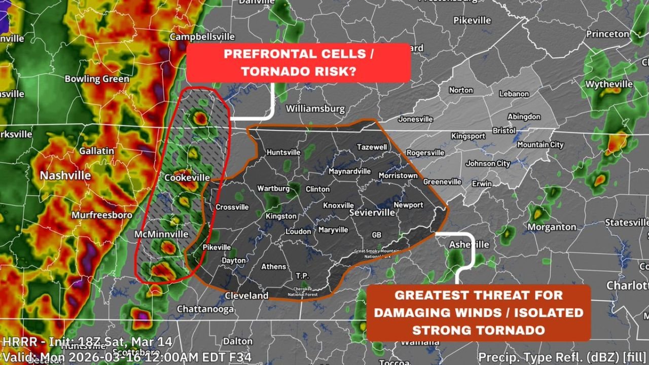
Damaging Winds Could Be the Primary Threat
Meteorologists say the most widespread hazard from the storm system will likely be damaging straight-line winds, which could exceed 60 miles per hour in stronger storms.
Such winds are capable of causing:
- Downed trees
- Power outages
- Structural damage
- Hazardous travel conditions
In addition to damaging winds, a few tornadoes could also develop, especially within stronger storm cells embedded in the line of storms.
Pre-Frontal Storm Cells Could Increase Tornado Risk
One area of concern involves the potential development of pre-frontal thunderstorms ahead of the main storm line, particularly across parts of the Plateau region.
Short-range weather models have indicated that isolated storms could form ahead of the main squall line, creating a scenario where storms may become more intense.
If these pre-frontal cells develop, they could produce:
- Large hail
- Localized damaging winds
- One or two tornadoes before the main storm line arrives
Because these storms could develop quickly, they may pose a greater risk for localized severe weather.
Storm System Driven by Strong Atmospheric Dynamics
The severe weather setup is associated with a large storm system moving across the central United States, accompanied by a powerful cold front.
Warm, unstable air flowing northward ahead of the front will interact with strong winds in the upper atmosphere, creating favorable conditions for organized thunderstorms.
Even though overall atmospheric instability may be somewhat limited overnight, the strength of the wind fields could compensate, allowing storms to maintain intensity.
Overnight Severe Weather Can Be Especially Dangerous
Meteorologists note that overnight severe weather events often pose additional safety challenges, since many residents may be asleep when warnings are issued.
Because of this, officials recommend that residents across Tennessee and Kentucky take precautions before going to bed Sunday night.
Recommended safety preparations include:
- Enabling Wireless Emergency Alerts on smartphones
- Using a NOAA weather radio with alarm capability
- Monitoring local weather updates before bedtime
Having reliable warning methods can help ensure people receive alerts if severe storms develop overnight.
Residents Encouraged to Stay Weather Aware
Although not every storm will become severe, the combination of strong wind shear, a powerful jet stream and an advancing cold front creates an environment capable of producing dangerous storms.
Forecasters will continue monitoring new data as the storm system approaches, and details about storm intensity and exact locations could still change.
However, early indications suggest that parts of Tennessee and Kentucky could face a notable early-morning severe weather event Monday, with damaging winds and isolated tornadoes possible.
Stay with WaldronNews for the latest updates as meteorologists track this developing overnight severe weather threat across Tennessee and Kentucky.