
Tennessee and Virginia Could See Midweek Snow as Rain Changes to Snow Showers Wednesday Night, With Best Accumulations in East Tennessee Mountains and Southwest Virginia
TENNESSEE — A midweek weather system is expected to bring rain on Wednesday that transitions to snow showers Wednesday evening, with snowfall gradually diminishing on Thursday. Forecast data indicates the highest chances for measurable snow accumulation will be focused in East Tennessee, the northern Tennessee Valley, and southwest Virginia, particularly in higher elevations.
How the Midweek System Is Expected to Unfold
According to forecast guidance, precipitation will begin as rain during the daytime hours Wednesday, before colder air moves in behind the system. As temperatures fall Wednesday evening, rain is expected to change over to snow showers, especially across elevated terrain.
Snow activity is forecast to taper off during the day Thursday, though lingering flurries may persist in the mountains.
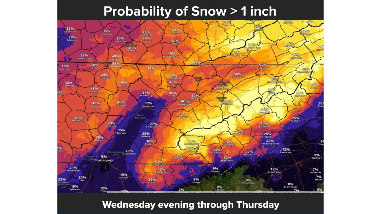
Where Snow Accumulation Is Most Likely
Probability maps show the greatest chance of more than 1 inch of snow in:
- The East Tennessee mountains
- Portions of the northern Tennessee Valley
- Southwest Virginia, particularly near the higher ridges
While higher elevations have the best odds of seeing accumulating snow, some valley locations could still pick up light accumulations, especially in northeast Tennessee and southwest Virginia.
What the Probability Data Shows
Current snow probability guidance highlights:
- Moderate to locally high probabilities for over 1 inch of snow in mountainous areas
- Lower, but non-zero chances in nearby valleys
- Reduced snow potential farther south and west, where rain is more likely to dominate
The sharp contrast in probabilities reflects the strong role elevation will play in this event.
Travel and Safety Concerns
Even limited snowfall could lead to slick and hazardous road conditions, particularly:
- Wednesday night into early Thursday morning
- On mountain roads and higher passes
- In shaded and less-traveled areas where temperatures cool faster
Drivers are urged to remain cautious during overnight and early morning travel.
Why This Is a Lower-End but Notable Snow Event
Forecasters note that this system does not appear to be a major winter storm, but it carries enough cold air and moisture to produce localized travel impacts, especially in higher terrain. Small temperature changes could still influence how much snow actually accumulates.
Bottom Line
Rain on Wednesday is expected to transition to snow showers Wednesday evening across parts of Tennessee and Virginia, with the best chance for more than an inch of accumulation in the East Tennessee mountains, the northern Tennessee Valley, and southwest Virginia. Snow will gradually diminish on Thursday, but slick conditions may linger into the morning hours.
Residents in affected areas should monitor forecast updates as timing and snowfall amounts become clearer.
For continued regional weather coverage and midweek impact updates, stay connected with Waldron News and share conditions from your area as the system moves through.