
Tennessee, Arkansas and Mississippi Under Growing March 15 Severe Storm Watch as Forecast Models Highlight Nashville and Memphis Tornado Potential
TENNESSEE — Meteorologists are closely monitoring the possibility of severe weather developing across parts of the Mid-South on Sunday, March 15, with new model forecasts highlighting a growing risk corridor stretching from Arkansas and Mississippi into western and middle Tennessee.
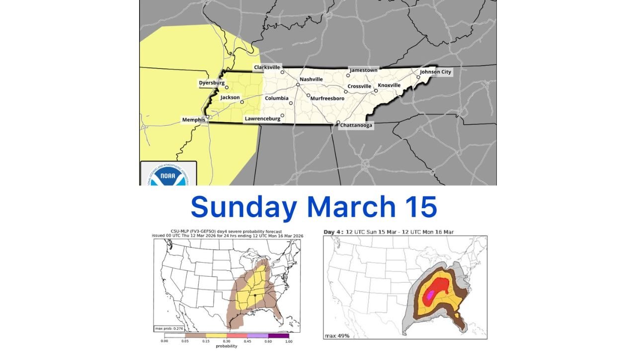
While the Storm Prediction Center’s official Day 4 outlook has not yet highlighted Middle Tennessee, several research and university forecast models are beginning to flag the region as an area worth watching for potential severe storms.
Cities including Memphis, Jackson, Clarksville, Nashville, and Columbia sit within the zone that meteorologists say could experience thunderstorms if the developing storm system evolves as currently projected.
Research Forecast Models Highlight Middle Tennessee
One of the graphics being closely examined comes from Colorado State University’s Day 4 severe probability forecast, which shows a corridor of elevated severe weather potential extending from the Lower Mississippi Valley through Tennessee and into parts of the Ohio Valley.
In that model guidance, Middle Tennessee — including the Nashville metro area — appears inside the highlighted severe weather probability zone.
Another research model, the NCAR Convective Hazard Forecast, also indicates potential severe storm development in roughly the same region.
These models do not represent official warnings but are used by meteorologists to evaluate early signals of possible severe weather patterns several days in advance.
Memphis and Western Tennessee Already in Official Risk Area
The official Storm Prediction Center Day 4 outlook currently places the western edge of Tennessee — including areas near Memphis and Dyersburg — inside a broader severe weather monitoring zone.
This region often serves as the transition area where severe storms forming in Arkansas or Mississippi move eastward into Tennessee.
If the storm system develops as some models suggest, thunderstorms could organize along a corridor stretching from:
- Little Rock, Arkansas
- Memphis, Tennessee
- Jackson, Tennessee
- Toward Nashville and central Tennessee
However, meteorologists stress that it is still early in the forecast process.
Forecast Still Several Days Away
Because the potential event is still several days out, the exact location of severe storms could change significantly as new data becomes available.
Weather patterns in the United States often shift as forecast models update, especially when dealing with severe weather setups that depend on subtle atmospheric changes.
Small adjustments in:
- Temperature
- Moisture
- Wind shear
- Storm timing
can dramatically shift where severe storms ultimately develop.
For this reason, forecasters say the current outlook should be viewed as an early signal rather than a final forecast.
What Meteorologists Are Watching
As the potential storm approaches, meteorologists will closely monitor several key atmospheric ingredients that could determine whether severe weather develops.
These include:
- Warm, moist air moving north from the Gulf of Mexico
- Increasing wind shear capable of supporting rotating storms
- A strong upper-level disturbance moving across the region
If these ingredients align across the Mid-South, thunderstorms could strengthen into severe storms capable of producing damaging winds, large hail, or isolated tornadoes.
Residents Encouraged to Stay Alert
Although it is too early to determine the exact severity of the potential storm system, residents across Tennessee, Arkansas, and Mississippi should stay aware of forecast updates as March 15 approaches.
Meteorologists will continue analyzing updated model runs over the coming days to determine whether the severe weather threat becomes more widespread or shifts to other areas.
Communities across Memphis, Jackson, Nashville, Clarksville, and surrounding regions are encouraged to monitor official forecasts and be prepared for changing conditions if the severe weather threat increases.
Stay with WaldronNews for the latest updates as meteorologists track the developing March 15 storm threat across Tennessee and the Mid-South.