
Tennessee, Kentucky, Arkansas, Missouri and North Carolina Face High-Impact Winter Storm With Potential 6–12 Inches of Snow and Dangerous Ice
TENNESSEE — A major winter storm is increasingly likely to impact a large portion of the Mid-South and Southeast this weekend, with new model guidance pointing to widespread heavy snow, significant ice accumulation, and dangerous cold temperatures across multiple states.
Latest forecast data suggests this system could evolve into one of the most disruptive winter storms in years for parts of Tennessee, Kentucky, northern Georgia, and the Carolinas, while surrounding states remain on a razor-thin edge between heavy snow and little to no accumulation.
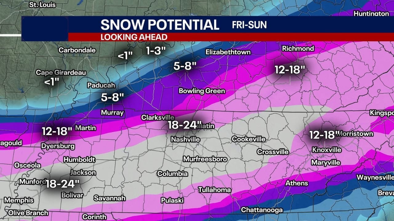
Heavy Snow Potential Focused on Tennessee and the I-40 Corridor
Confidence continues to grow that middle and western Tennessee sit near the core of this storm’s snow axis. Forecast models indicate a broad zone of 6–12 inches of snow, with localized bands exceeding 12 inches possible.
The I-40 corridor, including Memphis, Jackson, Nashville, and Clarksville, appears especially vulnerable if current trends hold. Nashville, in particular, stands out as a city to watch closely. Historically, the city has recorded 10 inches or more of snow only seven times, with the most recent major event producing 11.3 inches in February 1979. The all-time record remains 17.3 inches in March 1892.
If projected totals verify, this storm could rank as a top-10 snowstorm in Nashville’s recorded history.
Sharp Snow Cutoff Creates Forecast Uncertainty
One of the most challenging aspects of this forecast is the extremely sharp northern cutoff in snowfall. Models show a dramatic transition from 12+ inches of snow to virtually nothing within a 1–2 hour drive.
This puts parts of southern Missouri, western Kentucky, and southern Indiana in a high-risk uncertainty zone. Cities such as Paducah, Springfield, Joplin, and Evansville could either experience a significant snowfall or see minimal accumulation depending on small shifts in storm track.
This sharp gradient is driven by a powerful Arctic air mass to the north, which has the potential to shove the entire system southward at the last minute.
Significant Ice Threat Across Georgia and the Deep South
While snow dominates farther north, ice may become the primary hazard farther south, especially across Georgia, Alabama, and parts of South Carolina.
Forecast guidance highlights Metro Atlanta and surrounding areas as particularly vulnerable to freezing rain and sleet, with enough ice accumulation to cause tree damage, power outages, and hazardous travel. Ice storms in this region often produce greater impacts than snow due to infrastructure and vegetation sensitivity.
Bitter Cold Raises Impact Risk
Compounding the situation is an incoming surge of extreme cold, with overnight lows projected to fall into the single digits or below zero across portions of Tennessee, Kentucky, and the Mid-South early next week.
If significant ice accumulates before temperatures plunge, prolonged power outages become a serious concern. Some locations could challenge cold records dating back to the 1960s and 1980s, creating a dangerous combination of ice damage and life-threatening cold.
What Still Needs to Be Watched
Although confidence is high that a major winter weather event is coming, exact placement of the heaviest snow and ice bands remains uncertain. Small shifts over the next 24–48 hours will determine which communities see historic impacts and which remain just outside the storm’s reach.
Residents across the affected states should closely monitor updates and prepare now for rapidly changing conditions, travel disruptions, and potential power outages.
Waldron News will continue providing updates as new data becomes available and confidence in specific impacts increases. Stay prepared and stay informed.