
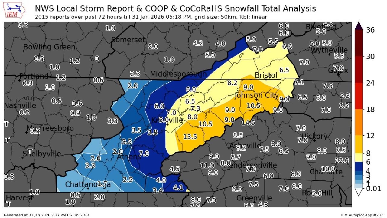
Tennessee Winter Storm Delivers Overachieving Snowfall Across East Tennessee, With Knoxville Area Near Halls Recording 8.2 Inches
TENNESSEE — A powerful late-January winter storm exceeded expectations across East Tennessee, producing a memorable snowfall event for communities east of Interstate 81 and delivering some of the highest totals of the season across the Tennessee Valley and southern Appalachians.
According to combined NWS Local Storm Reports, COOP observations, and CoCoRaHS data, snowfall totals surged well beyond forecast ranges in several areas, with Knoxville recording 8.2 inches near Halls, cementing this storm as one of the most impactful winter events of the month for the region.
East Tennessee Emerges as the Snowfall Bullseye
Snowfall analysis shows a pronounced band of heavier accumulation stretching from Knoxville eastward through Johnson City, where mesoscale forcing and favorable terrain enhancement helped wring out higher totals.
Notable snowfall amounts include:
- Near Halls (Knoxville area): 8.2 inches
- Johnson City region: 9 to locally 10.5 inches
- Portions of northeast Tennessee: 6 to 8 inches
- Southern Appalachian foothills: locally higher totals approaching double digits
This corridor stood out sharply compared to surrounding areas, where totals dropped off quickly just west and south of the main snow band.
Sharp Gradient Highlights Overachieving Nature of the Storm
One of the most striking features of this event was the tight snowfall gradient across relatively short distances.
While parts of Middle Tennessee struggled to reach even 1 inch, communities farther east saw snowfall totals climb rapidly from 3–4 inches to over 8 inches in a matter of counties. Areas around Athens and Chattanooga generally measured 2 to 4 inches, underscoring how narrowly focused the heaviest snow axis became.
Forecasters note that this type of sharp contrast is typical in Appalachian-influenced winter systems, where elevation, banding, and storm track alignment play an outsized role.
Why This Storm Stands Out
Meteorologists are calling this an “overachieving” event because snowfall exceeded guidance in several key zones — particularly east of I-81 — where persistent snow bands lingered longer than expected.
Key contributing factors included:
- Prolonged lift within the deformation zone
- Cold thermal profiles supporting efficient snow growth
- Terrain-enhanced snowfall along the eastern Tennessee Valley
- Slower eastward progression of the snow shield
For many residents, this storm will be remembered as one of the more impressive January snowfalls in recent years.
Travel, Power, and Community Impacts
Despite the heavy snow, impacts were somewhat mitigated by cold surface temperatures that prevented widespread icing. However, travel disruptions were common, especially on secondary roads and higher-elevation routes.
Local officials reported:
- Slick and snow-covered roadways
- Delayed school and government operations
- Isolated power issues in heavier snow zones
- Increased demand for road treatment and plowing operations
Final Takeaway
For East Tennessee, this storm lived up to the hype — and then some.
The 8.2-inch snowfall near Halls, combined with widespread 6- to 10-inch totals across the Knoxville–Johnson City corridor, makes this event one to remember for anyone east of I-81. It also serves as a reminder that winter storms in the Tennessee Valley can still deliver high-impact snow when conditions align just right.
Did this storm overperform where you live? Share your snowfall totals and experiences with WaldronNews, and stay tuned for continued winter weather coverage as the season moves forward.