
Texas, Arizona, New Mexico and California Could See Rare Extreme Warmth While New York, Pennsylvania and New England Turn Colder
UNITED STATES — Long-range weather models are signaling a highly unusual temperature pattern developing across the United States during mid-March, with forecasters highlighting a rare signal showing extreme warmth across the western United States while colder air settles across parts of the Northeast.
Meteorologists say the forecast includes one of the strongest above-average temperature probability signals seen in extended outlooks, particularly across states such as Texas, Arizona, New Mexico, Nevada and California.
Rare 90 Percent Warm Temperature Signal Appears in Forecast
The latest 8–14 day temperature outlook covering March 16 through March 22 shows an exceptionally strong probability for warmer-than-normal temperatures across the western half of the country.
In parts of the Southwest and West Coast, forecast guidance suggests greater than 90 percent probability of above-average temperatures, which forecasters note is extremely rare in long-range outlooks.
The highest confidence for unusually warm conditions currently centers over:
- Arizona
- New Mexico
- Nevada
- California
- Texas
- Utah
- Colorado
This region may experience a prolonged stretch of spring-like or even early-summer-like warmth as a large ridge of high pressure builds over the western United States.
Powerful Upper-Level Ridge Driving Western Heat
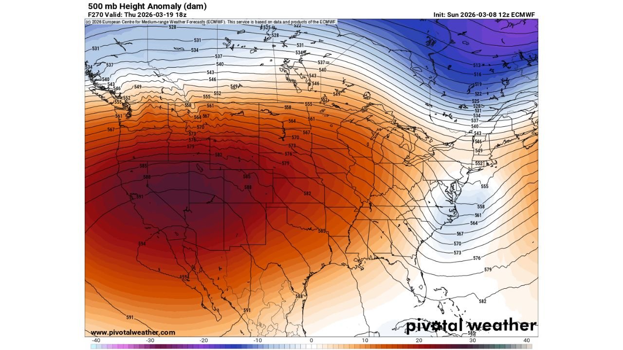
Atmospheric model guidance shows a strong ridge of high pressure forming over the Southwest and western United States, extending northward through the Rocky Mountains.
Forecast maps of 500-millibar height anomalies indicate a large dome of warmer air dominating the western half of the country.
This ridge is expected to:
- Suppress storm systems
- Allow more sunshine
- Promote above-normal daytime temperatures
The ridge also pushes the jet stream northward across western Canada, allowing warm air to expand across much of the West and parts of the central United States.
Cooler Pattern Developing Across the Northeast
While the West warms significantly, the same atmospheric pattern may drive colder-than-normal conditions across the northeastern United States.
States most likely to experience below-average temperatures include:
- New York
- Pennsylvania
- Vermont
- New Hampshire
- Maine
- Massachusetts
- Connecticut
- Rhode Island
Forecast maps show a trough developing over eastern Canada and the Northeast, which may funnel cooler air southward into the region.
This pattern contrast highlights a classic west-ridge, east-trough configuration, where one side of the country experiences warm conditions while the other cools down.
Midwest and Southern States May See Transitional Temperatures
Between the warm West and cooler Northeast lies a transition zone across parts of the central United States.
States such as:
- Kansas
- Missouri
- Arkansas
- Oklahoma
- Louisiana
- Mississippi
- Alabama
may experience temperatures closer to seasonal averages, depending on how the ridge and trough shift over time.
However, some areas in the southern Plains could still see warmer-than-normal temperatures spreading eastward from Texas.
Forecast Highlights Strong Pattern Confidence
Meteorologists say multiple model solutions—including ensemble guidance—are consistently showing a large ridge centered over the Southwest, increasing confidence in the overall temperature pattern.
The strong agreement among models is one reason forecasters have issued such high probability values in the extended temperature outlook.
While exact daily temperatures will vary, the broader signal strongly favors warmer conditions in the West and cooler weather in parts of the Northeast during the March 16–22 period.
Mid-March Weather Pattern May Bring Sharp U.S. Temperature Divide
If the forecast verifies, the United States could see one of the most pronounced temperature contrasts of the season, with much of the western United States experiencing unusually warm conditions while colder air returns to parts of the Northeast.
Meteorologists say the evolving pattern will continue to be monitored closely as new model runs refine the details in the days ahead.
Stay with WaldronNews for continuing updates as forecasters track this developing mid-March temperature pattern across the United States.