
Texas, Louisiana and Southwest Oklahoma Brace for Tornado Risk as Intensifying QLCS Targets Houston, Shreveport and East Texas Corridor
UNITED STATES — A rapidly organizing quasi-linear convective system (QLCS) is taking shape across Texas and Louisiana, bringing an increasing risk of embedded tornadoes and damaging wind gusts from the Houston metro northward through East Texas and into western Louisiana. At the same time, parts of Southwest Oklahoma are seeing smaller storms develop with the potential for cold air funnels.
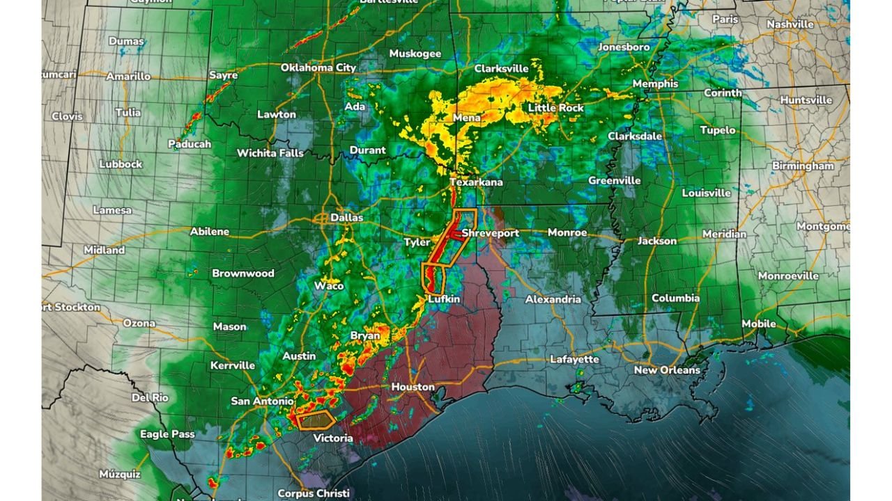
Radar imagery shows a well-defined squall line stretching from near Victoria and Corpus Christi north through San Antonio, Austin, Bryan, Lufkin, Tyler and into Shreveport, with heavy rainfall extending north toward Texarkana, Mena and Little Rock.
QLCS Strengthening from the Gulf Coast to East Texas
The main concern is the strengthening QLCS — a solid line of thunderstorms capable of producing both widespread damaging winds and isolated tornadoes. Instability is building out ahead of the line, and atmospheric conditions both in front of and even behind the boundary are becoming supportive of storm organization.
A ramping up low-level jet is enhancing wind shear across the region. This setup creates a more favorable environment for:
- Embedded areas of rotation within the line
- Brief tornado spin-ups
- Strong, damaging straight-line wind gusts
The most intense segment currently appears from Victoria and Houston northward through Lufkin toward Shreveport, where radar shows bowing segments and embedded cores.
Houston and Southeast Texas in the Primary Risk Zone
A broad swath of Southeast Texas — including Houston, Beaumont and coastal counties along the upper Texas Gulf Coast — is under heightened concern. The red-shaded area extends eastward into western Louisiana, including Shreveport, Monroe and Alexandria.
Within this corridor, storms are capable of producing:
- Damaging wind gusts exceeding 60 mph
- Isolated tornadoes embedded within the line
- Torrential downpours reducing visibility
The linear nature of the system suggests wind damage may become more widespread than tornado impacts, but quick spin-ups remain possible — especially where segments bow outward or kink along the line.
East Texas to Arkansas: Heavy Rain and Embedded Storm Cores
Farther north, widespread rain is overspreading Texarkana, Mena and Little Rock, with heavier embedded cores rotating through portions of southern Arkansas. While the severe threat may be somewhat lower there compared to Southeast Texas, pockets of stronger storms could still produce gusty winds.
The instability axis remains strongest from central and eastern Texas into western Louisiana.
Southwest Oklahoma Monitoring Cold Air Funnel Potential
In Southwest Oklahoma, including areas west and south of Lawton, a few smaller storms are beginning to take shape. While these are not currently as organized as the main Texas-Louisiana line, forecasters note the environment could support cold air funnels.
Cold air funnels:
- Are typically weak and short-lived
- May resemble tornadoes but often do not reach the ground
- Form beneath cold-core upper-level systems
Residents in SW Oklahoma should remain weather-aware, though the overall tornado risk there appears limited compared to the Gulf Coast states.
Storm Line Progression
The squall line is expected to continue pushing east and northeast through the day:
- Houston metro and Southeast Texas: Ongoing severe threat
- Lufkin to Shreveport corridor: Elevated tornado and wind risk
- Monroe and western Mississippi later: Storms advancing east
- Little Rock area: Heavy rain with embedded stronger cells
As the low-level jet continues to intensify, rotation potential within the line may increase before storms gradually weaken later in the evening.
Primary Hazards at a Glance
Across Texas and Louisiana, the most significant threats include:
- Isolated embedded tornadoes
- Damaging straight-line wind gusts
- Heavy rainfall and localized flooding
- Frequent lightning
Travel conditions could deteriorate quickly, especially along I-10 near Houston, I-45, US-59 through East Texas, and I-20 near Shreveport.
What Residents Should Do
Residents across Southeast Texas, East Texas and western Louisiana should:
- Keep phones charged and alerts enabled
- Monitor local weather updates closely
- Be prepared to move indoors quickly if warnings are issued
- Avoid driving through heavy rain bands
Those in Southwest Oklahoma should also stay aware, especially if isolated funnel clouds are observed.
This evolving severe weather setup from Victoria and Houston north to Shreveport and into Arkansas highlights a classic QLCS wind and tornado scenario fueled by increasing wind shear and instability.
Stay with WaldronNews.com for continued tracking as this storm system progresses eastward and additional warnings are issued.