
Texas, Oklahoma and Kansas Face Conditional Severe Weather Sunday as Large Hail, Damaging Winds and Tornadoes Possible From San Antonio to Wichita
DALLAS, Texas — A highly conditional but potentially dangerous severe weather setup is in place for Sunday, April 12, as forecasters warn that if storms are able to develop across the Texas, Oklahoma, and Kansas corridor, the environment will be more than capable of supporting large hail, damaging winds, and a few tornadoes from San Antonio all the way north to Wichita.
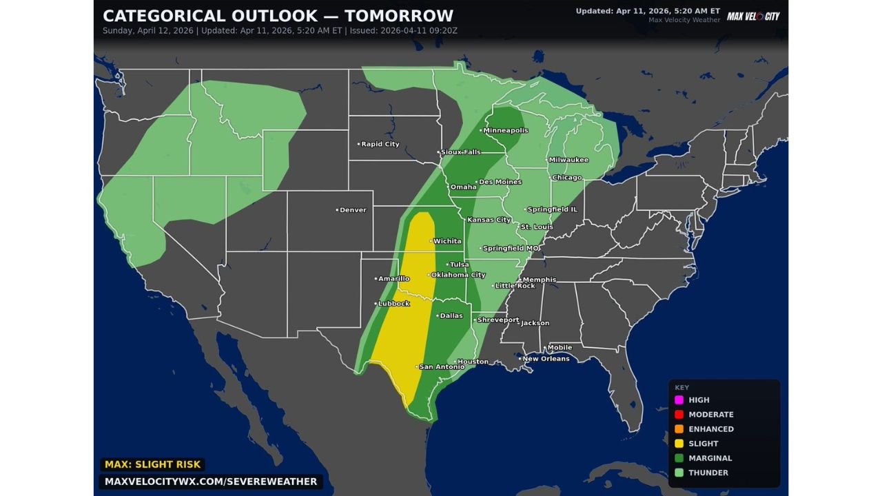
The greatest severe weather potential is focused along a corridor stretching from San Antonio, Texas through Dallas, Oklahoma City, and Tulsa up to Wichita, Kansas, according to the latest outlook issued by Max Velocity Weather, with a Slight Risk zone covering the heart of this corridor as of Sunday, April 12, 2026.
Cities and States in the Risk Zone
- Texas: San Antonio, Dallas, Lubbock, Amarillo, and Houston sit within the risk zone — San Antonio to Dallas corridor carries the highest local concern
- Oklahoma: Oklahoma City and Tulsa are directly inside the Slight Risk zone where tornado potential is greatest
- Kansas: Wichita falls at the northern end of the primary severe weather corridor
- Missouri: Springfield and surrounding areas sit within the broader Marginal Risk zone
- Arkansas: Little Rock and surrounding communities fall within the outer Marginal Risk zone
- Louisiana/Mississippi: Shreveport, Jackson, and Memphis sit on the eastern edge of the broader threat area
Primary Threats
Sunday’s setup is described as highly conditional — meaning the threats below only materialize if storms can actually develop and fire. If they do, forecasters say the atmosphere will support:
- Large hail — The environment has enough instability to support significant hail-producing thunderstorms across the San Antonio to Wichita corridor
- Damaging winds — Straight-line wind damage is possible with any storms that develop Sunday afternoon and evening
- Tornadoes — A few tornadoes cannot be ruled out, particularly across the Oklahoma City, Tulsa, and Dallas metro areas where atmospheric conditions are most favorable
Why This Matters for Texas and Oklahoma
The core of Sunday’s threat sits directly over some of the most populated metro areas in Texas and Oklahoma. Cities like Dallas, Oklahoma City, and Tulsa are no strangers to severe weather, but a setup where tornadoes are possible — even under conditional circumstances — demands attention from residents across the region.
The critical factor forecasters are watching is whether morning convection — storms that fire overnight and into the early morning hours — will stabilize the atmosphere and prevent afternoon storm development. If morning storm activity exhausts the available energy and lift remains absent through the afternoon, storms may simply not develop and the threat fizzles out entirely.
However, if the cap breaks and storms do fire during the afternoon hours, they will be entering an environment primed for severe weather. The Max Velocity Weather categorical outlook shows the Slight Risk zone in yellow centered directly over the Wichita to San Antonio corridor — a clear signal that forecasters are not dismissing this day, even with the conditional nature of the setup.
Multi-Day Pattern
Sunday represents a separate and distinct severe weather event from the Monday system that is also being tracked across the Midwest. Residents across Texas, Oklahoma, and Kansas are potentially facing a back-to-back severe weather stretch heading into the new week, with Sunday’s conditional threat followed closely by Monday’s more organized severe weather setup further north.
Forecasters are urging residents to stay updated through Sunday morning as clarity on storm development potential improves significantly closer to the event. The conditional nature of this setup means the forecast could trend either direction — more threatening or less threatening — as Sunday’s atmosphere becomes clearer.
What to Watch Next
- Watch for morning convection on Sunday — if heavy storms develop overnight, the afternoon severe threat may drop significantly
- Monitor SPC and Max Velocity Weather updates Sunday morning for any changes to the Slight Risk area boundaries
- Dallas, Oklahoma City, and Tulsa residents should have weather alerts active on their phones throughout Sunday afternoon
- If storms do fire, tornado warnings could come with little lead time — know your shelter location before Sunday afternoon arrives
- The San Antonio to Wichita corridor is the primary watch zone — if you live along this line, treat Sunday as a weather-aware day regardless of how the morning looks
The setup is conditional, but the potential is real. Residents across Texas, Oklahoma, and Kansas are urged to stay informed through Sunday morning and take any watches or warnings seriously if storms develop during the afternoon and evening hours.
WaldronNews.com will continue tracking this Sunday severe weather setup across Texas, Oklahoma, and Kansas and will provide updates as storm development potential becomes clearer throughout the day.