
Texas, Oklahoma, Arkansas, Louisiana, and Mississippi Could Face First Severe Weather Threat of 2026 as Strong Southern Trough Develops
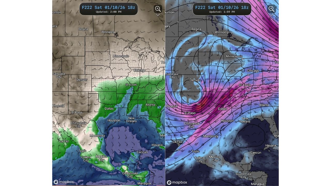
UNITED STATES — Weather models are signaling the potential for the first notable severe weather setup of 2026, as a strong upper-level trough is forecast to move across the southern United States sometime between January 8 and January 10, according to the latest GFS model and GEFS ensemble guidance.
While the system remains several days out and details are still evolving, forecasters are closely monitoring the setup due to its classic ingredients for severe weather, including strong upper-level winds, increasing moisture from the Gulf of Mexico, and a developing surface storm track.
Strong Upper-Level Trough Emerging Across the Southern U.S.
Forecast maps show a deepening trough digging into the Southwest and Southern Plains, with strong jet-stream support extending from northern Mexico into Texas, Oklahoma, Arkansas, and the Lower Mississippi Valley.
This type of pattern is often associated with:
- Strong wind shear
- Rapid storm organization
- Potential severe thunderstorms if instability develops
The strongest dynamics currently appear focused from Texas into the central Gulf Coast states, placing multiple states in a zone that will need close monitoring.
Moisture Return from the Gulf Could Fuel Storm Development
Model guidance indicates southerly flow strengthening off the Gulf of Mexico, allowing moisture to surge northward into:
- Eastern Texas
- Louisiana
- Mississippi
- Alabama
If this moisture overlaps with daytime heating and the approaching trough, strong to severe thunderstorms could develop, including the risk for damaging winds and heavy rainfall. At this time, specific hazards such as tornadoes or hail cannot yet be determined.
Timing Window: January 8–10 Remains Uncertain
The forecast window currently centers on January 8 through January 10, but meteorologists caution that:
- The system could shift east or west
- Strength could increase or weaken
- Severe weather may fail to materialize if key ingredients do not align
Because the event is still several days away, confidence in exact impacts remains limited, and residents should avoid drawing conclusions from single model runs.
Why Forecasters Are Watching This Closely
Despite the uncertainty, this setup stands out as one of the first meaningful severe weather signals of the new year, particularly for the southern U.S., where winter severe weather is not uncommon.
The combination of:
- A strong trough
- Increasing wind energy
- Gulf moisture return
makes this system worth watching closely over the coming days.
What Happens Next
Additional model runs over the next several days will help determine:
- Whether storms develop
- Which states face the highest risk
- If severe weather becomes more likely
At this stage, this is a signal to stay alert — not a warning.
Waldron News will continue tracking this developing system and provide updates as confidence increases. If you live in Texas, Oklahoma, Arkansas, Louisiana, or Mississippi, now is a good time to stay weather-aware and check back for the latest forecasts and updates.