
Texas, Oklahoma, Arkansas, Louisiana, and Mississippi Could See Milder but Wetter Early January Pattern as Southern Jet Stream Becomes Active
UNITED STATES — Long-range forecast data is signaling a notable shift in the early January weather pattern across the Central and Southern United States, with the greatest impacts expected in Texas, Oklahoma, Arkansas, Louisiana, and Mississippi, according to ensemble model guidance and jet-stream analysis.
Central and Southern U.S. Weather Pattern Shows Increased Rain Potential While Arctic Cold Remains Locked in Canada
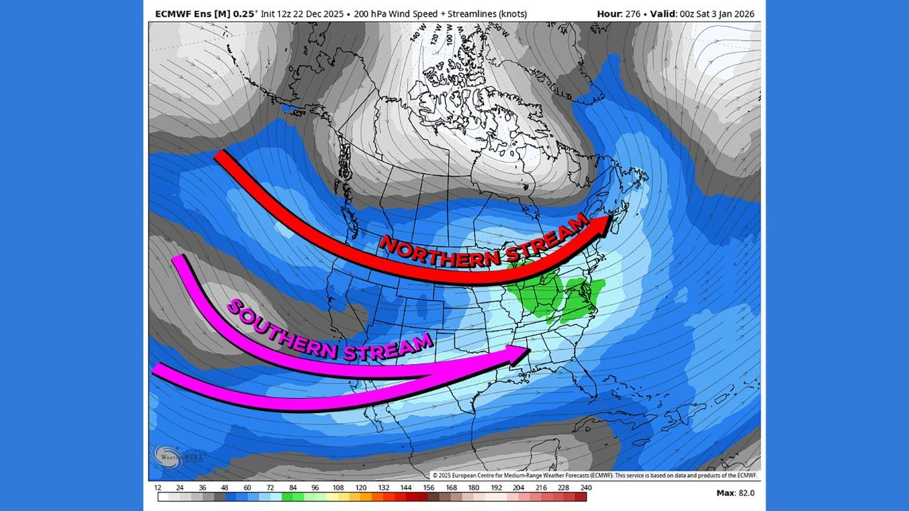
Forecast imagery shows a strengthening Southern jet stream becoming increasingly active as it moves east from the Pacific. At the same time, very cold air remains confined to Alaska and western Canada, with no clear pathway south into the continental United States during the early part of January.
Areas Most Likely to Be Impacted
Based on the provided data, the highest confidence impacts are expected across:
- Texas
- Oklahoma
- Arkansas
- Louisiana
- Mississippi
These states sit directly beneath the active southern branch of the jet stream, which typically favors milder temperatures combined with increased moisture and storm activity. This pattern often leads to frequent rain events, cloud cover, and temperature swings rather than sustained cold.
Secondary Impact Zone Extends Into the Tennessee Valley and Ohio Valley
While the core of the pattern favors the southern Plains and lower Mississippi Valley, secondary impacts may extend into:
- Tennessee
- Kentucky
- Missouri
- Southern Illinois
- Southern Indiana
In these areas, the interaction between the southern stream and weaker northern energy could bring periods of rain, occasional mixed precipitation, and unsettled conditions, though confidence decreases farther north.
Why Arctic Cold Is Not a Factor — Yet
The data clearly shows strong cold air reservoirs over Alaska and western Canada, but the Northern jet stream remains positioned too far north to deliver that cold southward. Without proper phasing between the northern and southern streams, sustained cold outbreaks or widespread snow are unlikely in the short term.
Forecasters note that if cold air were to eventually break free and align with the active southern stream later in January, winter weather risks could increase, but this remains speculative and highly uncertain at this range.
What Residents Should Prepare For
For now, residents in the Central and Southern U.S. should plan for:
- Above-normal temperatures
- Increased rainfall potential
- Periods of unsettled weather
- Localized flooding risks in low-lying or poor drainage areas
Winter storm chances remain low in the near term, but weather patterns will continue to be monitored closely as January progresses.
Looking Ahead
Meteorologists caution that long-range patterns beyond 10 days can evolve quickly. While this setup may ultimately result in a routine wet stretch, it is one worth watching due to its potential impacts on travel, agriculture, and river levels across the southern half of the country.
Stay with WaldronNews.com for continued updates as we track changes to this developing early-January weather pattern. Share this report and let us know how conditions look in your area.