
Texas, Oklahoma, Arkansas, Missouri, Illinois and Indiana Brace for Unusually Warm, Storm-Soaked Start to March as Flood Risk Builds Across the Central and Eastern U.S.
UNITED STATES — March is arriving with a dramatic shift in weather across the Central and Eastern United States, as forecast models signal an unusually mild and increasingly active pattern that could quickly raise flooding concerns from Texas and Oklahoma through Arkansas, Missouri, Illinois and Indiana.
New 7–14 day ensemble guidance valid into mid-March shows widespread temperature anomalies running well above normal — in some areas by 10 to 20 degrees — stretching from the Southern Plains through the Mississippi Valley and into the Great Lakes and Northeast.
Springlike Warmth Expands Across the Plains and Midwest
The temperature anomaly outlook highlights:
- Strong above-normal warmth centered over Texas, Oklahoma, Arkansas, Missouri, Illinois and Indiana
- Mild air pushing north toward the Great Lakes
- Cooler air largely confined to the far western U.S.
This setup points toward a sustained early taste of spring rather than a brief warmup.
Repeated Storm Systems Target the Same Region
At the same time, precipitation guidance shows above-normal rainfall probabilities across many of the same states.
Areas most favored for increased rainfall include:
- Eastern Texas and much of Oklahoma
- Arkansas and Missouri
- Southern Illinois and Indiana
Instead of a single storm, the pattern favors multiple systems tracking across the Central U.S., increasing the risk of cumulative rainfall.
Flooding Concerns Could Rise After Early March Rounds
With repeated rain events, soils can saturate quickly — especially if storms arrive back-to-back.
Forecasters note that:
- River levels could begin responding after the first few rounds
- Low-lying and flood-prone areas may need monitoring
- Warmer temperatures could accelerate runoff in northern zones
If heavier rainfall pockets align over the same region, localized flooding concerns would increase.
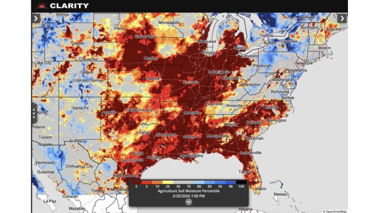
Soil Moisture Improvement — With Tradeoffs
Current soil moisture data shows dryness in parts of the Midwest and Southern Plains. The upcoming wet pattern should improve those deficits across:
- Arkansas farmland
- Missouri and Illinois agricultural zones
- Portions of Texas and Oklahoma cropland
However, rapid improvement sometimes comes in bursts of heavy rainfall that temporarily overwhelm drainage systems.
The Big Picture
The developing pattern features:
- Persistent above-normal temperatures
- An active jet stream across the Central U.S.
- Limited signals of a prolonged dry stretch
That combination makes for a stormy and unusually warm start to March across Texas, Oklahoma, Arkansas, Missouri, Illinois and Indiana.
Bottom Line
An unseasonably warm and increasingly wet pattern is setting up across the Southern Plains and Midwest, with Texas, Oklahoma, Arkansas, Missouri, Illinois and Indiana all in the zone for repeated storm systems and potential rising flood concerns.
WaldronNews.com will continue tracking rainfall totals and temperature trends as this early-March weather regime unfolds across the central United States.