
Texas, Oklahoma, Arkansas, Missouri, Illinois, Tennessee, and Georgia Face One of the Hottest Christmas Days on Record
UNITED STATES — A highly unusual Christmas Day heat pattern is expected to affect a large portion of the country, with tens of millions of people experiencing spring-like or even summer-like temperatures across the Southern Plains, Lower Mississippi Valley, Midwest, and Southeast. Forecast data shows this could rank among the warmest Christmas Days ever recorded for several states.
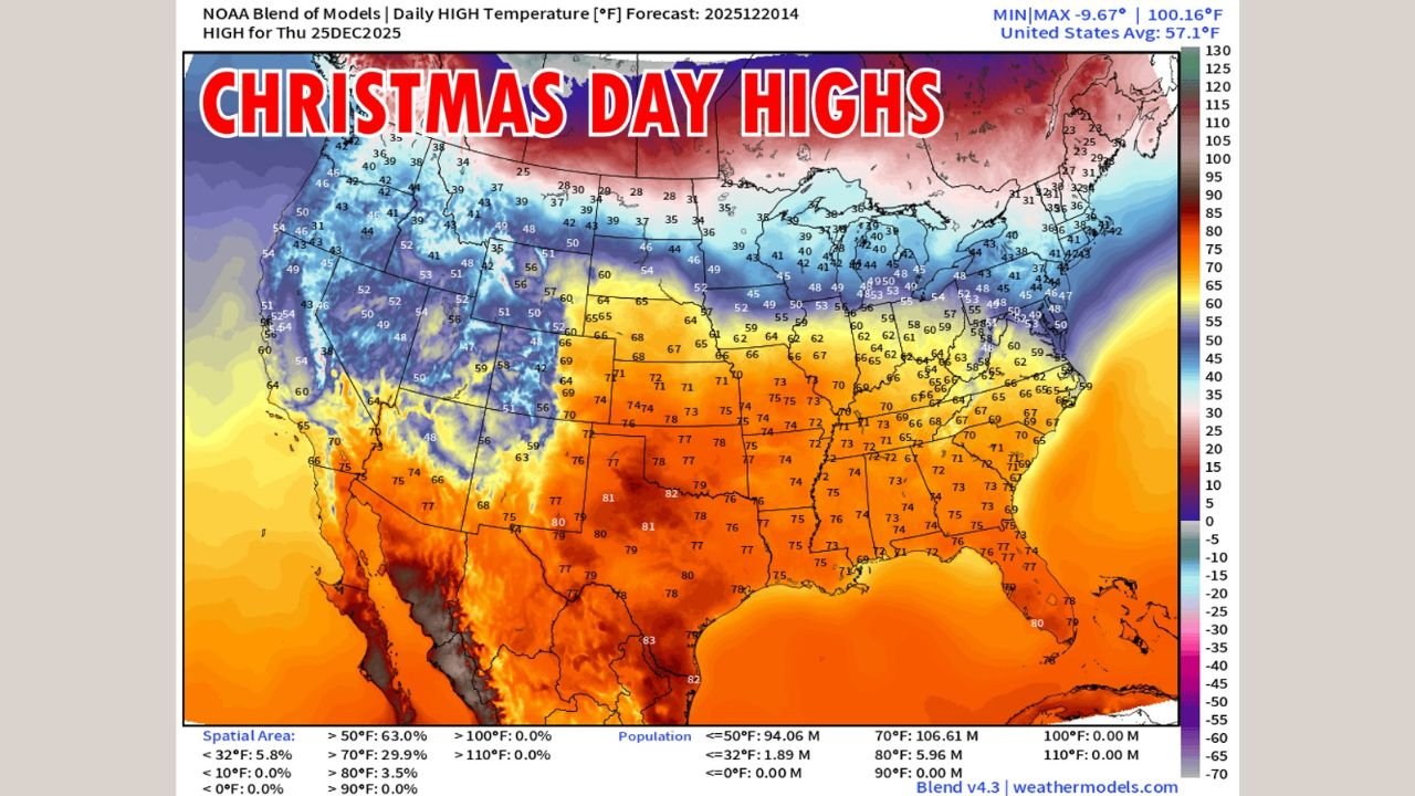
Temperature projections indicate 106 million people will experience highs above 70°F, while nearly 6 million could see temperatures exceeding 80°F, a staggering departure from late-December averages.
Southern Plains See Summer-Like Heat
The most extreme warmth is expected across Texas and Oklahoma, where widespread highs in the upper 70s to lower 80s are forecast. Parts of central and southern Texas may briefly exceed 80°F, levels more typical of late spring than Christmas Day.
This heat is supported by strong warm air aloft, with temperature anomalies showing values 15–25°C above normal at the 850-mb level, signaling an exceptionally strong and persistent warm air mass.
“This is not just mild — this is record-threatening warmth for late December.”
Midwest Experiences Record-Level Warmth
Farther north, Missouri and Illinois are expected to see highs in the low to mid-70s, which is remarkable for Christmas Day. These temperatures are 25–35 degrees above seasonal norms, placing several locations within range of daily records.
Snow cover across the region is minimal, allowing solar heating and warm southerly winds to further enhance surface temperatures.
Southeast Feels Like Early Spring
In the Southeast, Tennessee and Georgia will also experience unusually warm conditions, with highs reaching the low to mid-70s. While humidity will not be extreme, it will be noticeable for December, adding to the spring-like feel.
Many residents may spend Christmas outdoors, with weather conditions more typical of March than late December.
Why This Is Happening
The images show a large, dominant ridge of high pressure covering much of the central and eastern United States. This pattern blocks cold Arctic air from moving south while drawing warm air northward from the Gulf region.
At the same time, colder air remains locked across the northern Rockies and parts of Canada, creating an extreme temperature contrast across the continent.
What Comes Next
This pattern is expected to be short-lived, but it serves as a reminder of how volatile winter weather can be. A return to more seasonal conditions is possible later, though timing remains uncertain.
For now, Christmas 2025 will be remembered not for snowflakes, but for record warmth across much of the country.
WaldronNews.com will continue tracking this evolving weather pattern and provide updates if records fall or conditions change.