
Texas, Oklahoma, Arkansas, Missouri, Kentucky, Tennessee, West Virginia, Virginia, Pennsylvania, New York, and New England States Face a Massive Winter Storm With Widespread Snow, Ice, and Freezing Rain This Weekend
UNITED STATES — A powerful and far-reaching winter storm is expected to deliver snow, sleet, and freezing rain across a massive portion of the southern and eastern United States this weekend, impacting tens of millions of people and creating dangerous travel and infrastructure conditions from the Southern Plains to the Mid-Atlantic and Northeast.
Forecast data shows this system becoming most widespread early Sunday morning, when precipitation types will overlap across an enormous geographic area, including major population centers that are not accustomed to prolonged winter weather impacts.
Storm Coverage Expected to Peak Early Sunday Morning
According to the forecast timeline, around 4 a.m. Sunday, this storm is expected to reach its maximum extent. At that point, snow, sleet, or freezing rain may be falling simultaneously across areas home to roughly 193 million people, representing more than half of the contiguous U.S. population.
This overlap of precipitation types significantly raises the risk of rapidly deteriorating road conditions, especially overnight when temperatures are lowest and visibility is reduced.
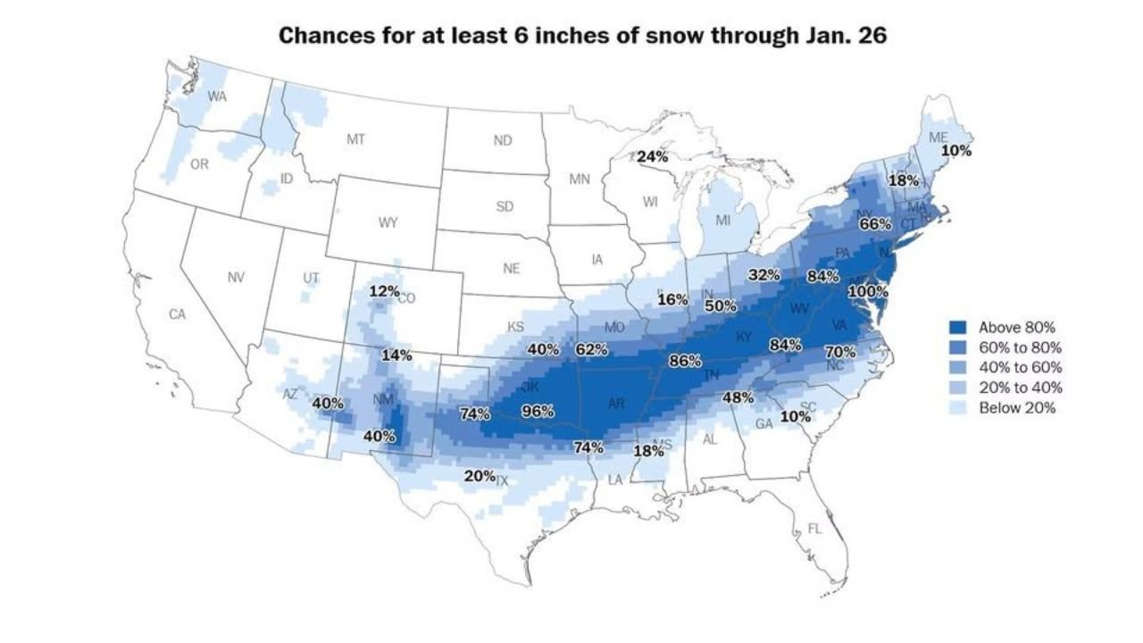
High Probability Snow Corridor Stretches From the Southern Plains to the Northeast
Model guidance shows a long, continuous swath of high snow probabilities extending from parts of Texas and Oklahoma through Arkansas, Missouri, Kentucky, Tennessee, West Virginia, Virginia, Pennsylvania, and into New York and New England.
In this corridor, probabilities for at least 6 inches of snow are notably high, with several areas showing greater than 60% to 80% chances, and isolated locations displaying even higher modeled probabilities. While these values represent statistical output rather than guarantees, they strongly indicate the potential for significant snowfall totals.
Ice and Mixed Precipitation Increase Impact Risk in Southern and Eastern States
South of the heavy snow axis, freezing rain and sleet are expected to mix in, particularly across portions of the South and southern Appalachians. Ice accumulation, even in relatively small amounts, can dramatically increase the risk of power outages, downed trees, and impassable roadways.
Because freezing rain often falls as liquid before freezing on contact, road pretreatment may be less effective, allowing ice to build quickly once precipitation begins.
Travel Disruptions Likely From Saturday Through Sunday Night
With the storm unfolding over a weekend, interstate travel, regional air traffic, and local road networks are all likely to be affected. Overnight travel late Saturday into Sunday morning may be especially dangerous as conditions worsen rapidly while many drivers are asleep or unprepared.
Officials typically urge residents to avoid unnecessary travel, particularly during peak storm hours when emergency response times may be slower.
Why This Storm Is Especially Concerning
What sets this system apart is not just snowfall potential, but its sheer geographic scale and population impact. Very few winter storms manage to affect more than half of the contiguous United States simultaneously, especially with multiple hazardous precipitation types occurring at once.
Even locations that do not see extreme snowfall totals may still experience significant disruption due to ice, sleet, or rapidly changing conditions.
Bottom Line
This weekend’s winter storm has the potential to become one of the most impactful cold-season events of the season so far, stretching from the Southern Plains through the Ohio Valley and into the Northeast. Residents across the affected states should finalize preparations now, closely monitor local forecasts, and be ready for rapidly changing conditions as the storm evolves.
Stay with Waldron for continued updates as newer data refines the storm’s track, timing, and impacts.