
Texas, Oklahoma, Arkansas, Tennessee, Kentucky, and Virginia Face Major Winter Storm From Friday Through Monday With Heavy Snow, Destructive Ice, and Dangerous Post-Storm Cold
UNITED STATES — A long-lived and potentially dangerous winter storm is expected to develop across the southern and eastern United States late this week, spreading from Texas and Oklahoma through Arkansas, Tennessee, Kentucky, Virginia, and into the Mid-Atlantic as cold Arctic air collides with deep tropical Pacific moisture.
Forecast data shows this system evolving into a multi-day winter storm beginning as early as Friday, intensifying through Saturday and Sunday, and lingering into Monday, with a dangerous mix of heavy snow, significant ice accretion, and freezing rain across a broad region.
Storm Setup: Why This System Is So Dangerous
Meteorological guidance shows a strong jet stream diving across the southern U.S., fueled by a surface low developing near Baja California, drawing in abundant Pacific moisture. At the same time, a powerful Arctic high pressure system presses southward, forcing bitter cold air into the storm’s path.
This collision creates an ideal setup for:
- Heavy snowfall north of the storm track
- A pronounced warm nose aloft, allowing freezing rain south of the snow band
- Prolonged precipitation due to the storm’s slow movement
The result is a long-duration winter storm, not a quick-hitting event.
Snowfall Threat: One to Two Feet Possible
Model data indicates a swath of 1 to 2 feet of snow is possible from parts of:
- Arkansas
- Tennessee
- Kentucky
- West Virginia
- Virginia
Areas just north of the freezing-rain zone will see the heaviest snowfall rates, with snowfall lasting many hours and creating near-whiteout conditions at times.
Ice Storm Risk: Significant Ice Accretion South of the Snow Band
Just south of the heavy snow axis, the threat shifts from snow to destructive freezing rain.
Forecast guidance highlights:
- Widespread ice accretion
- Potential for ½ inch or more of ice in spots
- Power-line and tree damage likely
The most concerning ice impacts stretch from Texas and Oklahoma through Arkansas and Tennessee into parts of the southern Appalachians, where surface temperatures remain below freezing while warmer air flows overhead.
This type of setup is notorious for extended power outages and dangerous travel conditions.
Timing Breakdown
- Friday: Precipitation begins across Texas, Oklahoma, and Arkansas
- Saturday: Storm intensifies; snow and ice rapidly expand eastward
- Saturday Night–Sunday: Peak impacts with heavy snow and freezing rain
- Monday: Storm exits, but hazards continue due to extreme cold
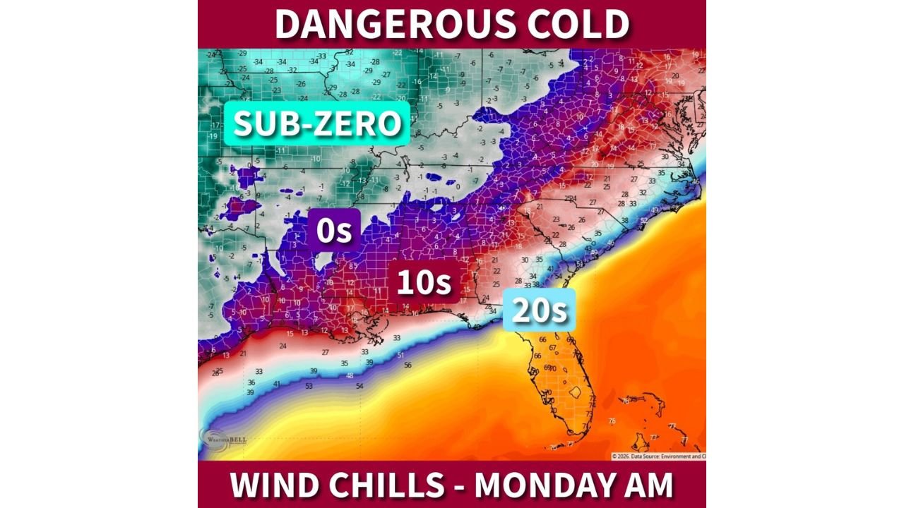
Dangerous Cold Follows the Storm
After the storm departs, extreme cold will surge southward behind it.
Forecast wind chills by Monday morning include:
- Sub-zero wind chills across parts of the Midwest and Ohio Valley
- Single-digit wind chills reaching deep into the South
- Teens and lower 20s even along parts of the Gulf Coast
Combined with power outages from ice damage, this cold could become life-threatening, especially along and north of the I-20 corridor.
What Residents Should Do Now
Residents across the impacted states should prepare immediately:
- Protect pipes and outdoor plumbing
- Charge devices and prepare for power outages
- Avoid unnecessary travel during peak storm periods
- Check on elderly neighbors and vulnerable populations
- Secure pets and livestock ahead of the cold surge
Bottom Line
This is not a minor winter event. Forecast confidence is increasing that a major winter storm will impact a large portion of the southern and eastern U.S., bringing heavy snow, damaging ice, dangerous travel, power outages, and extreme cold.
Conditions will continue to evolve, and small shifts in the storm track could significantly change local impacts. Residents across Texas, Oklahoma, Arkansas, Tennessee, Kentucky, Virginia, and the Mid-Atlantic should remain alert and prepared for rapidly changing weather conditions. More updates are expected as the storm draws closer.