
Texas, Oklahoma, Arkansas, Tennessee, Kentucky, Georgia, Alabama, North Carolina, and Virginia Face Dangerous Freezing Rain and Ice Accretion From Saturday Through Early Monday
UNITED STATES — A significant freezing rain and ice accretion event is expected to develop across large portions of the southern and southeastern United States this weekend, with conditions worsening from Saturday into Sunday and potentially lingering into Monday. Forecast models indicate a wide corridor of icing stretching from North Texas and Oklahoma through Arkansas, Tennessee, Kentucky, northern Georgia, Alabama, and into the Carolinas and southern Virginia, raising concerns for travel disruptions, power outages, and infrastructure damage.
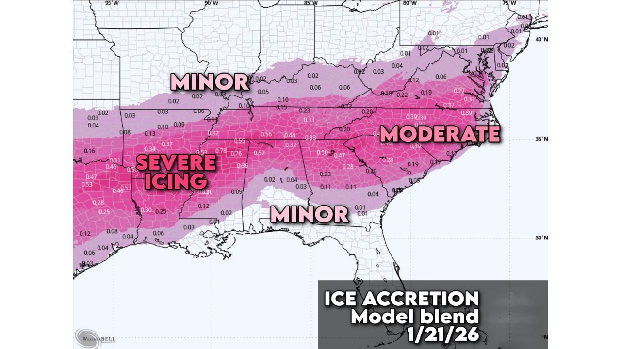
Meteorological guidance shows a clear gradient of icing severity, with severe ice accretion possible in parts of Texas, Oklahoma, and Arkansas, moderate icing across much of the Tennessee Valley and central Appalachians, and lighter—but still impactful—ice amounts extending into the Carolinas and Virginia.
Severe Icing Likely Across Parts of Texas, Oklahoma, and Arkansas
The highest-risk zone for dangerous ice accumulation includes Dallas–Fort Worth, Tyler (Texas), Oklahoma City, Little Rock, Pine Bluff, and Shreveport. In these areas, ice accretion values may exceed 0.25 inches, with some locations potentially approaching 0.50 inches or more.
Ice of this magnitude is capable of snapping tree limbs, bringing down power lines, and making roadways nearly impassable. Even untreated surfaces such as bridges, overpasses, and elevated roadways could become hazardous in a short amount of time once freezing rain begins.
Moderate Ice Accumulation Expected From Tennessee to the Carolinas
A broad zone of moderate icing is forecast from Memphis, Nashville, Bowling Green, Huntsville, Chattanooga, Atlanta, Charlotte, Greensboro, Raleigh, Roanoke, and Richmond. While ice totals in these areas may be lower than in the severe zone, accumulations near or above 0.10 to 0.25 inches are still enough to cause widespread travel problems and scattered power outages.
Urban areas with heavy traffic may initially appear manageable, but conditions can deteriorate rapidly as freezing rain continues and surface temperatures remain below freezing.
Lighter but Impactful Icing Extends Into the Gulf Coast and Interior Southeast
Farther south, including portions of southern Alabama, southern Georgia, and parts of the Gulf Coast, lighter icing is possible. While accumulations are expected to remain on the lower end, even minor ice buildup can create slick road conditions and localized disruptions, especially overnight and during early morning hours.
Timing and Duration of the Ice Threat
Current data suggests freezing rain may begin late Saturday, intensify through Sunday, and persist into early Monday in some locations. The prolonged nature of the event increases the risk of compounded impacts, especially where ice builds layer upon layer.
Because freezing rain often falls as liquid before freezing on contact, road pre-treatment may offer limited protection once precipitation begins.
What Residents Should Do Now
Officials urge residents in the affected states to prepare immediately:
- Avoid unnecessary travel from Saturday through at least Sunday, and possibly Monday
- Fully charge phones, batteries, and power banks in case of outages
- Trim weak tree branches near homes and power lines if safe to do so
- Remove essential items from vehicles, as ice buildup may prevent doors from opening
- Keep rock salt available for use after icing begins, when it becomes effective
- Clean gutters to prevent ice-related drainage issues
- Fill gas tanks and prepare for possible supply delays
Bottom Line
This is shaping up to be a high-impact freezing rain event, particularly across Texas, Oklahoma, and Arkansas, with dangerous conditions extending well into the Southeast and Mid-Atlantic. Even areas labeled “minor” on ice maps should not underestimate the risks, as freezing rain often produces outsized impacts compared to snowfall.
Residents are urged to stay weather-aware, monitor local advisories, and finalize preparations before conditions deteriorate.
Stay with Waldron for continued updates as this ice threat evolves.