
Texas, Oklahoma, Arkansas, Tennessee, Kentucky, Virginia and North Carolina in Focus as Ensemble Models Align on Southern Plains–to–Mid-Atlantic Winter Storm Track
UNITED STATES — Forecast confidence is gradually increasing that a broad winter storm corridor may take shape from the Southern Plains into the Mid-Atlantic later this week, as multiple ensemble systems continue to cluster around a similar placement of the main precipitation axis. While details remain far from finalized, the latest ensemble guidance offers an important visual roadmap for where the most impactful weather could occur.
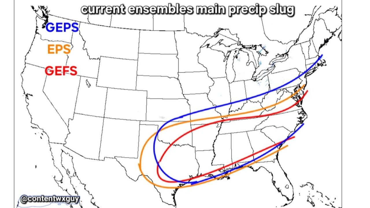
What the Ensembles Are Showing Right Now
The latest ensemble output from GEFS, EPS, and GEPS highlights a consistent signal for a main precipitation slug exceeding 0.5 inches of QPF, stretching from Texas and the lower Mississippi Valley northeastward into the Appalachians and Mid-Atlantic.
Although forecasters stress that this is not a final forecast, the agreement between these ensemble systems is notable at this range and helps narrow down which states should be paying closer attention.
Likely Storm Track: Southern Plains to the East Coast
Based on current ensemble placement, the favored storm corridor runs through:
- Texas and southern Oklahoma
- Arkansas and northern Louisiana
- Tennessee and Kentucky
- West Virginia and Virginia
- North Carolina and southern Mid-Atlantic
This track is significant because it places many of these areas on the cold side of a developing system, especially with Arctic air already pressing southward.
Why the Precipitation “Slug” Matters
The highlighted >0.5″ QPF zone represents where deep, sustained precipitation is most likely if the storm materializes. In winter setups like this, that matters because:
- North of the track: Higher chance for accumulating snow
- Along the track: Heavier precipitation rates
- South of the track: Greater risk for mixed precipitation or freezing rain
Small shifts north or south could dramatically change impacts for individual states, but the overall alignment across ensembles suggests this zone is not random noise.
Snow and Ice Outcomes Still Depend on Fine Details
While snow is favored on the northern side of the precipitation axis, ice remains a concern closer to the southern edge, where shallow cold air at the surface may undercut warmer air aloft.
This places parts of:
- Arkansas
- Tennessee
- Kentucky
- Virginia
- North Carolina
in a zone where snow, sleet, or freezing rain could all be possible depending on exact temperature profiles.
Why Forecasters Are Emphasizing Caution
Even with improving ensemble agreement, meteorologists continue to emphasize that:
- This is still a medium-range setup
- Exact snowfall and ice totals are not yet predictable
- Storm strength and placement can still shift
- One or two degrees of temperature change can alter impacts significantly
In other words, this is pattern recognition, not a final call.
What Residents Should Take Away Right Now
For now, residents across Texas, Oklahoma, Arkansas, Tennessee, Kentucky, Virginia, and North Carolina should:
- Be aware that a winter storm track is becoming more defined
- Expect forecast changes as higher-resolution models come into range
- Avoid reacting to single snow or ice maps
- Stay alert for National Weather Service updates later this week
This ensemble alignment does not guarantee a major winter storm, but it does confirm that the atmosphere is organizing in a way that could support one if trends continue.
Stay with Waldron News for continued analysis, clearer impact zones, and state-by-state updates as this potential winter storm comes into sharper focus.