
Texas, Oklahoma, Arkansas, Tennessee, Kentucky, Virginia, and the Mid-Atlantic Brace for Major Winter Storm With Heavy Snow, Destructive Ice, and Dangerous Cold From January 24–25 Into Early Next Week
TEXAS, OKLAHOMA, ARKANSAS, TENNESSEE, KENTUCKY, VIRGINIA, AND THE MID-ATLANTIC — A powerful and long-duration winter storm is increasingly likely to impact a large portion of the southern and eastern United States beginning Friday and intensifying through the weekend, with the most significant impacts expected from Saturday, January 24, through Sunday, January 25, followed by dangerous Arctic cold early next week.
Forecast guidance shows a high-impact setup developing as tropical Pacific moisture streams into the southern U.S. while strong Arctic high pressure pushes southward, creating an ideal environment for heavy snow, destructive ice accumulation, and hazardous travel conditions across multiple states.
Storm Setup Signals a Long-Lasting, High-Impact Event
Meteorological data indicates a strong jet stream streak draped across the southern U.S., allowing deep moisture to overrun entrenched cold air at the surface. At the same time, a powerful Arctic high—measured near 1048 mb in some guidance—anchors cold air across the central and eastern U.S.
This configuration supports a prolonged winter storm, rather than a quick-moving system, increasing the risk for significant accumulations and widespread disruption.
Forecasters note that details are still being resolved, particularly regarding the exact northern extent of snow and ice bands, but confidence is growing that this will be one of the most impactful storms of the past decade for parts of the region.
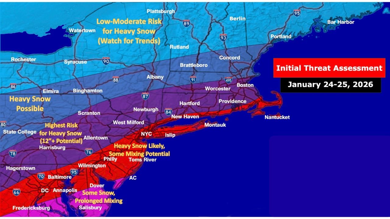
Heavy Snow Threat Expands From the Southern Plains to the Northeast
Snow is expected to develop as early as Friday, with the main event unfolding Saturday into Sunday, and possibly lingering into Monday in some areas.
Areas with the highest risk for heavy snowfall, including potential totals exceeding 12 inches, include:
- Parts of Texas Panhandle and North Texas
- Oklahoma and Arkansas
- Tennessee and Kentucky
- Virginia and portions of the Mid-Atlantic
- Interior sections of the Northeast, where some locations could see over a foot of snow
Farther north, snowfall amounts will depend heavily on how quickly warmer air aloft moves in, which remains one of the largest forecast uncertainties.
Destructive Ice Accumulation a Major Concern South of Snow Band
One of the most dangerous aspects of this storm is the significant ice threat, particularly just south of the heaviest snow axis.
European model data highlights a wide swath of freezing rain, with 1 to 2 inches or more of ice accretion possible from parts of Texas through Arkansas, Tennessee, Kentucky, and into Virginia.
This occurs as a pronounced warm layer aloft (“warm nose”) overruns sub-freezing air at the surface, allowing rain to freeze on contact. When precipitation rates are highest, pure freezing rain is favored, increasing the risk of:
- Widespread power outages
- Downed trees and power lines
- Extremely dangerous travel conditions
Snow, Sleet, and Freezing Rain May Change Over Time
Forecast guidance suggests precipitation type may shift multiple times, especially Saturday night into Sunday.
Snow may dominate early in the event, but some areas could transition to sleet or freezing rain as warmer air aloft advances northward. Exactly when—or if—this transition occurs remains uncertain and will be critical in determining final impacts.
Forecasters caution that oscillations in the storm track could still shift the most severe impacts north or south.
Dangerous Arctic Cold Follows the Storm Into Monday
After the storm exits, extremely dangerous cold air is expected to surge southward by Monday morning, reaching as far south as the north Gulf Coast.
Wind chill values are forecast to drop to:
- Sub-zero levels inland
- Single digits across much of the South
- Teens and low 20s along parts of the Gulf Coast
If power outages persist following the ice storm—especially along and north of the I-20 corridor—conditions could quickly become life-threatening.
Residents Urged to Prepare Now
Officials strongly encourage residents across the affected states to prepare well before the weekend, especially given the storm’s long duration and compounding hazards.
Preparation steps should include:
- Protecting pipes, plants, pets, and people
- Ensuring access to backup heat sources
- Avoiding unnecessary travel during peak storm periods
- Monitoring forecast updates closely as details evolve
Final Note
Whether this storm ultimately brings historic snowfall, crippling ice, or a dangerous mix of both, the message is clear: a major winter storm is likely, and impacts could extend well into next week.
Stay alert, stay prepared, and continue checking for updated forecasts as this high-impact system approaches.