
Texas, Oklahoma, Arkansas, Tennessee, Ohio, and Pennsylvania Face Increasing Risk of Snow, Ice, and Arctic Cold Late January
UNITED STATES — A broad and increasingly consistent winter weather signal is taking shape across the central and eastern United States as January enters its final stretch, with multiple forecast models pointing toward a potentially disruptive period of snow, ice, and bitter cold from late week into the weekend and beyond.
Long-range ensemble guidance from the European model, supported by U.S. outlooks, shows a large-scale pattern favorable for winter weather: strong western ridging, solid high-latitude blocking, and a deep Arctic cold source pressing southward into the Lower 48. This setup is forcing the jet stream to buckle and steer storm systems along a southern and central track, placing several highly populated regions under an elevated risk of winter impacts.
Large-Scale Pattern Favors Winter Weather Development
Forecast height anomalies at the mid-levels of the atmosphere show pronounced blocking across northern Canada and Greenland, effectively locking cold air in place over the central and eastern U.S. At the same time, persistent ridging over the western states is preventing systems from cutting northward, instead guiding them east-northeast along the boundary between Arctic air and milder southern air.
This configuration is classic for significant winter weather events, particularly when cold air is already established at the surface. Once cold air is entrenched, even modest moisture can produce impactful snow or ice.
Snow Corridor Extends from the Plains to the Ohio Valley and Northeast
Ensemble snowfall probabilities highlight a broad corridor with a meaningful chance of accumulating snow stretching from parts of the central Plains through the Mid-Mississippi Valley, Ohio Valley, and into the interior Northeast.
Several ensemble members show a solid signal for at least light to moderate snow, with some localized areas—particularly near and west of the Great Lakes and portions of the Midwest—showing potential for heavier totals. Short-range high-resolution guidance in parts of the Great Lakes region even suggests double-digit snowfall amounts where lake enhancement and favorable banding align.
While exact placement remains uncertain, confidence is growing that snow will be a significant player for a large portion of the central and eastern U.S.
Freezing Rain and Ice a Major Concern in the Transition Zone
Perhaps the most concerning aspect of the evolving forecast is the increasing signal for freezing rain and ice, especially across parts of the south-central U.S., the Tennessee Valley, and portions of the Southeast.
European ensemble guidance has shown mean ice accumulations approaching or exceeding 0.50 inches in some scenarios—an unusually high value at this forecast range. Ice of that magnitude can lead to widespread power outages, downed trees, and dangerous travel conditions.
However, forecasters caution that low-level temperature profiles remain marginal in some areas. A small shift in surface temperatures could mean the difference between a high-impact ice storm and a cold rain. This uncertainty will remain until higher-resolution guidance comes into range later this week.
Arctic High Pressure Brings Dangerous Cold and Wind Chills
Regardless of precipitation type, dangerous cold is expected to be a defining feature of this pattern. A strong Arctic high is forecast to settle over the northern Great Lakes, reinforcing sub-freezing temperatures across much of the Midwest, Ohio Valley, and Northeast.
Wind chill projections indicate sub-zero values for many areas, with some locations potentially experiencing wind chills as low as −20°F to −40°F during peak cold. These conditions increase the risk of frostbite, strain infrastructure, and exacerbate any winter weather impacts that develop.
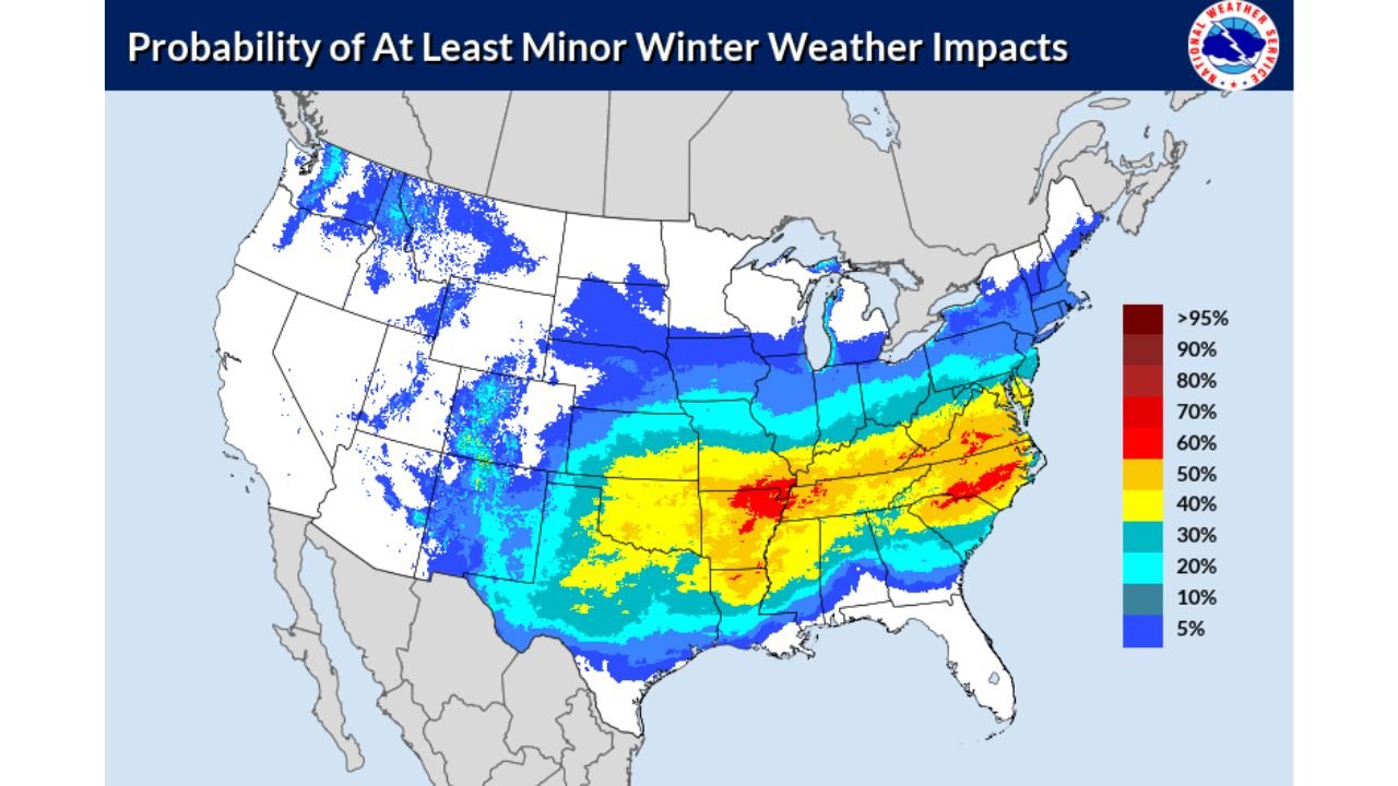
WPC Outlook Shows Rising Impact Probabilities
The Weather Prediction Center’s probabilistic outlooks show steadily increasing chances of at least minor winter weather impacts across a wide swath of the country from January 23 through January 26. The highest probabilities align well with the snow and ice corridor highlighted by ensemble guidance, lending additional confidence to the overall pattern.
While “minor impacts” may sound modest, forecasters note that these probabilities often rise quickly as systems come into shorter range—especially when cold air is already in place.
What Happens Next
At this stage, the forecast is high-confidence in the pattern but lower-confidence in exact impacts. Key details such as storm track, timing, and temperature profiles will be refined over the next several days. More specific snowfall and ice forecasts are expected by midweek, with higher confidence by Thursday.
Residents across the central and eastern United States should monitor forecasts closely, review winter preparedness plans, and be ready for potential travel disruptions, school closures, and power outages if ice becomes a dominant factor.
This late-January setup has the ingredients for a memorable stretch of winter weather—and how it ultimately unfolds will depend on small but critical details still coming into focus.