
Texas, Oklahoma, Kansas and Missouri on Alert as Forecasters Warn Strong Tornadoes Possible in Two-Day Severe Storm Outbreak
UNITED STATES — Meteorologists are warning of a significant severe weather outbreak unfolding across the Southern Plains and expanding into the Midwest over the next two days, with the greatest concern focused on northwest Texas, southwest Oklahoma, Kansas, and western Missouri. Forecast discussions indicate that supercell thunderstorms capable of producing tornadoes, large hail, and damaging winds may develop as atmospheric conditions become increasingly favorable.
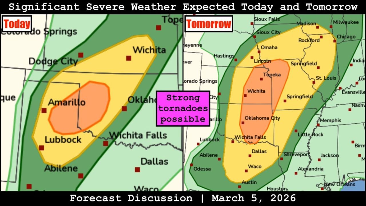
Forecasters say the threat will evolve in two distinct phases, beginning with storms across the Texas and Oklahoma region today before expanding northeast Friday toward the central Plains and Midwest.
Supercells Expected to Form Across Northwest Texas and Southwest Oklahoma
The first phase of the severe weather setup is expected to occur across northwest Texas and southwestern Oklahoma, including areas near Amarillo, Lubbock, Wichita Falls, and surrounding communities.
In this region, meteorologists expect isolated supercell thunderstorms to develop during the afternoon and evening hours, fueled by warm, unstable air moving northward from the Gulf of Mexico.
These storms could produce all severe weather hazards, including:
- Tornadoes
- Large hail
- Damaging wind gusts
While uncertainty remains regarding how many storms will develop, forecasters say any storm that becomes organized could quickly become severe due to favorable atmospheric wind patterns and instability.
The environment also suggests the possibility of strong tornadoes in the most intense storms, especially if supercells remain isolated before storms begin merging.
Severe Weather Threat Expands Northeast on Friday
The second and potentially more widespread phase of severe weather is expected to develop Friday as storms spread northeast from the Southern Plains into the Midwest.
Forecast maps show a large severe weather corridor stretching from north Texas and Oklahoma through Kansas and Missouri and into portions of Iowa, Illinois, and southern Wisconsin.
Cities including Oklahoma City, Wichita, Topeka, Kansas City, Springfield, St. Louis, and Des Moines could see strong thunderstorms during this period.
Within this corridor, atmospheric conditions may support supercell thunderstorms capable of producing tornadoes, damaging winds, and large hail.
Forecasters note that storms developing across Oklahoma and Kansas may intensify as they track northeast, potentially organizing into clusters or lines as they move toward Missouri and the Mississippi Valley.
Strong Tornadoes Possible in Highest Risk Area
The most concerning portion of the forecast highlights a corridor from central Oklahoma into southern Kansas, where conditions may allow storms to remain discrete long enough to produce tornadoes.
In this region, the combination of:
- Strong wind shear
- Deep atmospheric instability
- A strengthening low-level jet
could allow storms to rotate and produce strong tornadoes if supercells develop and persist.
Meteorologists stress that the exact tornado risk will depend on how storms evolve, as rapid storm clustering could limit tornado potential but increase the risk for widespread wind damage.
Damaging Winds and Large Hail Also Likely
Even in areas where tornadoes do not occur, damaging winds and large hail could become widespread hazards.
Storms developing along the dryline and frontal boundaries may produce:
- Wind gusts exceeding 60 to 70 mph
- Large hail potentially exceeding one inch in diameter
- Intense lightning and heavy downpours
As storms move northeast into Missouri and the Midwest, they may organize into larger storm complexes capable of producing widespread damaging winds.
Residents Across the Plains and Midwest Urged to Stay Alert
Because the severe weather threat could impact a large portion of the central United States, residents across the region are encouraged to closely monitor weather updates over the next 48 hours.
Preparation steps include:
- Keeping weather alerts enabled on mobile devices
- Identifying safe shelter locations in homes or workplaces
- Monitoring local forecasts as storm timing becomes clearer
Meteorologists say the setup has the potential to produce multiple rounds of severe weather from Texas to the Midwest, making it important for communities across the region to stay prepared.
Stay with WaldronNews for continuing coverage as this developing severe weather outbreak impacts the Southern Plains and Midwest.