
Texas, Oklahoma, Kansas, Arkansas, Iowa, Missouri, Louisiana, Illinois and Tennessee Brace for Unseasonable Christmas Warmth as Temperatures Run 30–35 Degrees Above Normal
UNITED STATES — A striking and highly unusual weather pattern is setting up across the central United States ahead of Christmas Day, with forecast data showing temperatures running 30 to 35 degrees above normal across a broad multi-state region. Meteorologists say this could lead to a “red Christmas” for millions, with spring-like warmth replacing typical late-December chill.
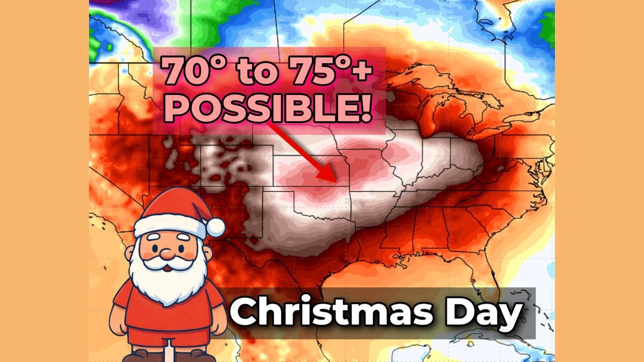
70s Possible Across Multiple Central States on Christmas Day
Forecast guidance indicates that high temperatures in the 70s may occur across several states, an outcome that would be extraordinary for late December. Areas from Texas and Oklahoma northward into Kansas, Missouri, and Iowa could experience highs more typical of April than Christmas.
“We could see 70s across half a dozen states,” forecasters noted, highlighting the scale of the warm air mass.
In Oklahoma, conditions are especially eye-catching. Oklahoma City could approach 80°F, compared to a normal Christmas Day high near 49°F.
Warmth May Reach as Far North as Illinois and the Midwest
The unseasonable warmth is not expected to stay confined to the southern Plains. Forecast models suggest 60-degree temperatures could push as far north as Illinois and Iowa, with cities such as Chicago, Des Moines, and Indianapolis potentially seeing temperatures rarely observed on Christmas Day.
“60s making it that far north would be remarkable for this time of year,” meteorologists said.
The warmth could also extend eastward, with Washington, D.C. potentially joining the list of cities experiencing unusually mild holiday weather.
Deep South and Lower Mississippi Valley Also Impacted
The warm air mass is expected to spread into the Deep South, affecting Arkansas, Louisiana, Tennessee, and surrounding areas. Residents in these regions may experience short-sleeve weather on Christmas, a stark contrast to typical winter conditions.
This widespread warmth will reduce the likelihood of snow across much of the central and southern U.S., reinforcing the “red Christmas” outlook.
Why This Extreme Warm Pattern Is Developing
Meteorologists attribute the pattern to a stagnant high-pressure system that is pushing the jet stream well north of its usual winter position. This configuration allows unseasonably warm Gulf air to surge deep into the heart of the country.
“The jet stream is being shunted north, opening the door for Gulf warmth to waft far inland,” forecasters explained.
Importantly, this outlook is not based on a single forecast run.
Multiple Forecast Models Support the Warm Christmas Outlook
The forecast is backed by several ensemble runs of the American GFS model, increasing confidence that the warmth is not a fluke.
“This isn’t just one singular model run — multiple ensemble members support the idea of significant warmth building in,” analysts said.
This multi-model agreement makes the unusual forecast more credible, though exact temperature values may still fluctuate slightly.
Potential Storm System to Watch After Christmas
While the warmth itself is the primary story, forecasters caution that clashing temperature boundaries could set the stage for a larger storm system during Christmas week. A developing low-pressure system feeding off these contrasts could bring active weather later in the period.
Details on that potential system remain uncertain, but meteorologists say it bears close monitoring.
WaldronNews.com will continue tracking this high-impact, multi-state Christmas weather pattern and provide updates as confidence increases and new data becomes available.