
Texas, Oklahoma, Kansas, Missouri and Illinois Enter Mid-April Alert Zone as Severe Storm Pattern Set to Return Across Plains and Central U.S.
UNITED STATES — A new weather alert is now being signaled across the country as forecasters point to a return of a more active and potentially severe weather pattern by mid-April, following a brief quiet stretch early next week.
This developing setup could bring multiple rounds of storms across the Plains and possibly into the Central and Eastern United States, making this a period residents should begin watching closely.
Quiet Break Before Pattern Turns Active Again
In the short term, conditions are expected to calm down:
- Early next week will feature a temporary lull in severe weather activity
- Much of the country, especially the Central U.S. and Midwest, will experience more stable and quieter conditions
- This break, however, is expected to be short-lived
Forecasters emphasize that this is simply a transition phase before a more dynamic setup returns.
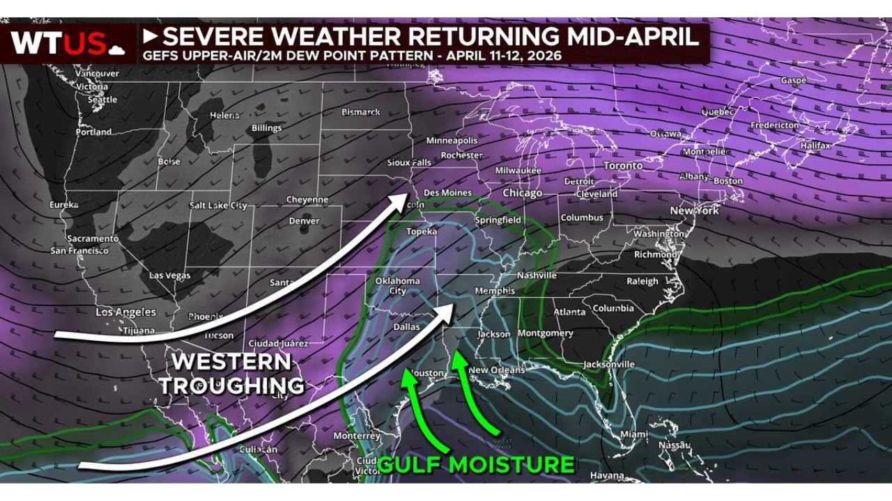
Strong Signal for Western Troughing Returns
Weather models are showing a clear and consistent trend toward western U.S. troughing, a key ingredient for severe weather outbreaks.
This pattern typically leads to:
- Increased storm system development across the Plains
- Stronger jet stream dynamics
- Enhanced lift and instability across central regions
As this trough develops, it will help organize storm systems and push them eastward.
Gulf Moisture Surge to Fuel Storms
Another critical factor in this setup is the return of deep Gulf moisture, which will stream northward into the Plains and Mississippi Valley.
This will provide:
- Higher humidity levels
- Increased atmospheric instability
- Favorable conditions for thunderstorm development and intensification
When combined with upper-level dynamics, this moisture could support multiple severe weather opportunities.
Plains Expected to Be Primary Focus
The initial focus area appears to center on:
- Texas, Oklahoma, Kansas, and surrounding Plains states
- Potential expansion into the Mississippi Valley and parts of the Midwest
While exact storm threats are not yet defined, the pattern suggests:
- Multiple storm days possible
- Increasing chances for organized severe weather episodes
- Gradual eastward progression depending on system evolution
7 to 10 Day Outlook Signals Increased Risk
Although specific storm details are still uncertain, the broader pattern is becoming clearer:
- The 7–10 day window shows a more favorable environment for severe weather
- Timing points toward late next week into next weekend as the more active period
- This could mark the next significant stretch of spring storm activity
What This Means Going Forward
Even without exact storm timing, the signals are strong enough to highlight:
- A shift back toward active spring weather
- Increased need for monitoring forecasts later next week
- The possibility of widespread storm development across central parts of the country
Final Outlook
After a brief period of calm, the United States is expected to transition back into a more volatile mid-April weather pattern, with the Plains and surrounding regions likely seeing the first impacts.
Residents across the Central U.S., Plains, and potentially the Midwest should begin preparing for changing conditions and renewed storm chances as early as late next week.
Stay with WaldronNews.com for continued updates as this developing severe weather pattern becomes clearer in the days ahead.