
Texas, Oklahoma, Kansas, Missouri, Iowa, and Illinois Put on Alert as Tuesday Severe Weather Setup Targets Midwest Warm Front Zone
UNITED STATES — A new round of potentially dangerous severe weather is beginning to take shape for next week, with Tuesday emerging as a key day to watch across parts of the Plains and Midwest.
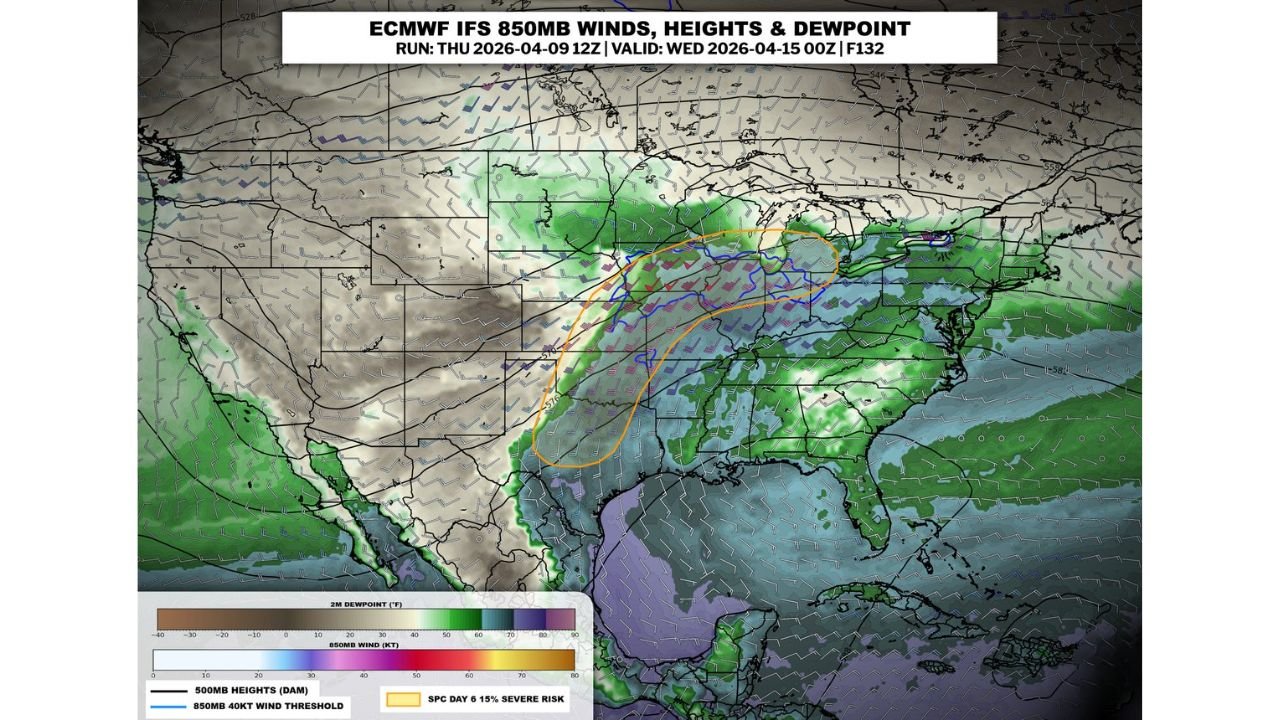
Forecast signals point to a large, unstable warm sector developing, combined with strong wind dynamics that could support organized storms, including the possibility of severe thunderstorms and isolated tornadoes.
Where the Main Risk Is Setting Up
The most concerning corridor currently stretches from:
- North Texas and Oklahoma
- Through Kansas
- Into parts of the Midwest, including Missouri, Iowa, and Illinois
This region aligns closely with a warm front boundary, where atmospheric conditions are expected to become increasingly favorable for storm development.
Why Tuesday Stands Out
Among the upcoming days, Tuesday is drawing the most attention due to a combination of factors:
- A broad warm sector bringing moisture-rich air northward
- Strengthening low-level jet stream winds, especially across the Midwest
- A focused zone of enhanced wind energy overlapping with warm, humid air
This overlap is critical, as it creates an environment capable of producing well-organized severe storms.
Wind Energy Could Be a Key Driver
Forecast data highlights a zone of 850mb winds exceeding 40 knots, particularly:
- Along and just south of the warm front
- Focused across parts of the Midwest into the central Plains
This setup suggests:
- Strong low-level wind shear
- Increased potential for rotating storms
- A corridor where storms could become more intense and long-lived
Primary Threats Expected
At this stage, the main hazards across the risk area include:
- Damaging wind gusts
- Large hail
- Potential for isolated tornadoes, especially in the Midwest corridor
While damaging winds and hail appear to be widespread threats, the tornado potential is something that is being closely monitored, particularly where wind shear is strongest.
Areas to Watch Closely
The highest concern currently centers on:
- Kansas and Missouri
- Iowa and Illinois
- Parts of Oklahoma and North Texas
These areas sit near the intersection of strong winds aloft and warm, moist surface air, a combination that often signals increased severe weather risk.
Pattern Still Evolving
It’s important to note:
- Specific details will continue to change as the event gets closer
- The exact placement of the warm front will determine where the highest impacts occur
- Additional updates are expected as confidence increases
Bottom Line
A potentially impactful severe weather setup is developing for next Tuesday across the Plains and Midwest.
With a strong warm sector, increasing wind energy, and favorable storm conditions, this is a situation that residents should begin monitoring now—especially across Kansas, Missouri, Iowa, and Illinois.
Stay alert as forecasts refine, because this setup has the potential to bring damaging storms and possibly tornadoes to parts of the central United States.