
Texas Oklahoma Kansas Missouri Rain Alert Issued as Widespread Heavy Rain Probabilities Surge Into Early Week
UNITED STATES — A widespread rainfall event is now taking shape across the central United States, with new probability data showing a high likelihood of measurable and heavy rain from Texas through Oklahoma, Kansas, and into Missouri and surrounding regions through early next week.
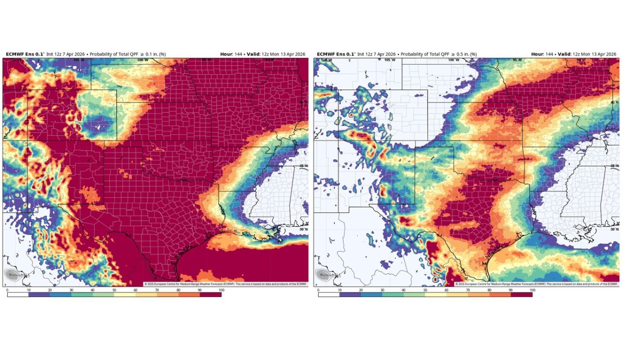
Forecast models indicate strong confidence in rain coverage, with increasing chances for moderate to heavy totals in key areas, especially across the southern and central Plains.
High Confidence in Rainfall Across Southern and Central Plains
Probability guidance shows that a large portion of the region has a very high likelihood of receiving at least 0.10 inches of rain, including:
- Texas
- Oklahoma
- Kansas
- Parts of Missouri
This signals that rainfall will be widespread rather than isolated, with most areas seeing at least some precipitation.
Increasing Odds for Moderate Rainfall Totals
As thresholds increase, the data still supports strong coverage:
- 0.50 inches or more likely across a broad zone from north Texas into Oklahoma and Kansas
- This suggests steady, soaking rainfall rather than brief passing showers
These totals are significant enough to:
- Improve soil moisture
- Support agricultural needs
- Begin building toward heavier accumulations in some areas
Heavy Rain Potential Focused on Texas and Oklahoma
The highest concern comes with 1.00 inch or greater rainfall probabilities, which are concentrated across:
- Central and North Texas
- Oklahoma
- Southern Kansas
This zone represents the core of the storm system, where repeated rounds of rain and storms could lead to:
- Localized flooding
- Water accumulation in low-lying areas
- Saturated ground conditions
Localized 2 Inch Rainfall Signals Stronger Storm Zones
Higher-end rainfall probabilities (2.00 inches or more) are more localized but still notable, especially across:
- Central Texas
- Parts of southern Oklahoma
These signals point to potential storm clusters or training thunderstorms, where rain repeatedly moves over the same areas.
Rain Band Extends Into Midwest
The broader rainfall pattern also stretches northeast into:
- Missouri
- Parts of the Midwest
While totals may be lower compared to Texas and Oklahoma, the region could still see:
- Consistent rainfall
- Embedded storms
- Gradual accumulation over time
Timing Through Early Monday
This rainfall outlook is focused through early Monday morning, meaning:
- Multiple rounds of rain are possible over several days
- Conditions may evolve as the system develops
- Final totals could shift depending on storm track and intensity
A Dynamic Pattern With Ongoing Adjustments
Forecast confidence is strong in the overall setup, but details such as:
- Exact rainfall placement
- Peak totals
- Storm timing
may continue to adjust as newer data becomes available.
What This Means for Residents
People across the Plains and Midwest should prepare for:
- Periods of steady rain and thunderstorms
- Possible localized flooding in heavier bands
- Changing conditions over multiple days
Travel and outdoor plans may be impacted, especially in areas expecting higher rainfall totals.
A Widespread Rain Event Is Now Developing
This setup reflects a broad and organized rain event impacting multiple states, with Texas, Oklahoma, Kansas, and Missouri at the center of the system.
With high probabilities for both widespread and locally heavy rainfall, this will be a key weather story to monitor through the start of next week.
Stay with WaldronNews.com for continuing updates as this rainfall event evolves and more precise totals become clearer.