
Texas Oklahoma Kansas Missouri Severe Weather Alert Issued as Three Day Storm Threat Targets Plains Into Midwest
UNITED STATES — A multi-day severe weather setup is now emerging from West Texas through the Plains into the Midwest, with three distinct risk periods expected from Saturday through Monday, signaling the start of what could be an increasingly active stretch of spring storms.
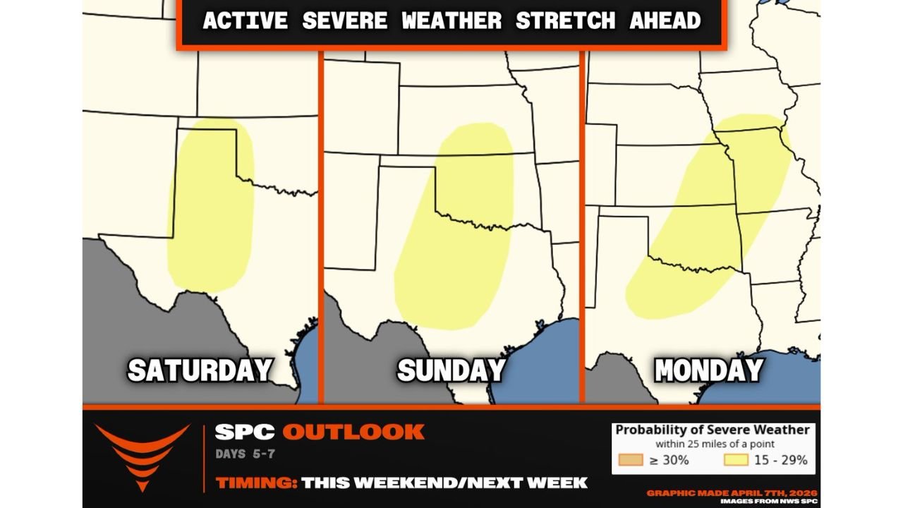
Forecast guidance shows three separate severe weather zones developing over consecutive days, raising concern for repeated storm impacts across the same general region.
Saturday Targets West Texas and Nearby Areas
The first round of storms is expected to develop on Saturday, focusing on:
- West Texas
- Areas near the New Mexico border
This initial setup may act as a precursor event, helping to establish the broader pattern that will intensify into Sunday and Monday.
Storms here could begin to organize along developing boundaries, setting the stage for stronger activity heading into the next day.
Sunday Shifts Into Central and North Texas With Higher Concern
By Sunday, the severe threat is expected to expand and intensify, shifting into:
- Central Texas
- North Texas
- Southern Oklahoma
This is where conditions may become more favorable for stronger storm development, especially if key atmospheric features align.
Cities in this zone include:
- Dallas
- Oklahoma City
- Wichita Falls
Forecast signals suggest that storm coverage and intensity could increase, making Sunday a critical day to watch.
Monday Extends Risk Into Kansas Missouri and Midwest
The final phase of this setup moves northeast on Monday, targeting:
- Kansas
- Missouri
- Parts of the Midwest
This progression indicates a classic Plains-to-Midwest storm track, where storms that initiate earlier in the Plains organize and move into more populated regions.
Peak Severe Threat Expected Sunday Into Monday
The overall pattern suggests that the highest severe weather potential will occur from Sunday into Monday, when:
- The storm system becomes more organized
- Atmospheric energy increases
- Storm coverage expands across multiple states
There is growing concern that this period could bring:
- Damaging winds
- Large hail
- Isolated tornado potential
Oklahoma City to Wichita Corridor Should Stay Alert
One area specifically highlighted for heightened attention is the corridor from:
- Oklahoma City, Oklahoma
- To Wichita, Kansas
If storms develop along a dryline boundary Sunday evening, this region could see rapid storm intensification, increasing the risk for severe weather.
A Sign of a More Active Pattern Ahead
This three-day setup is not just a one-time event. It reflects a larger shift toward a more active spring weather pattern, with:
- Multiple storm systems possible in the coming weeks
- Increasing frequency of severe weather events
- Conditions aligning with early peak-season behavior
What This Means for Residents
With multiple days of severe weather possible, residents across the Plains and Midwest should:
- Stay updated on daily forecast changes
- Be prepared for back-to-back storm chances
- Have alerts enabled for warnings
- Review safety plans ahead of time
Forecast Updates Will Continue to Evolve
While confidence is growing in this multi-day setup, details such as exact storm timing and intensity will continue to be refined over the coming days.
What remains clear is that a significant severe weather stretch is developing, and areas from Texas through the Midwest should begin preparing now.
Stay with WaldronNews.com as we continue tracking this developing severe weather pattern and provide updates as conditions become clearer.