
Texas Oklahoma Kansas Nebraska Iowa Severe Weather Alert Issued as Tornado Alley Enters Dangerous Mid April Phase
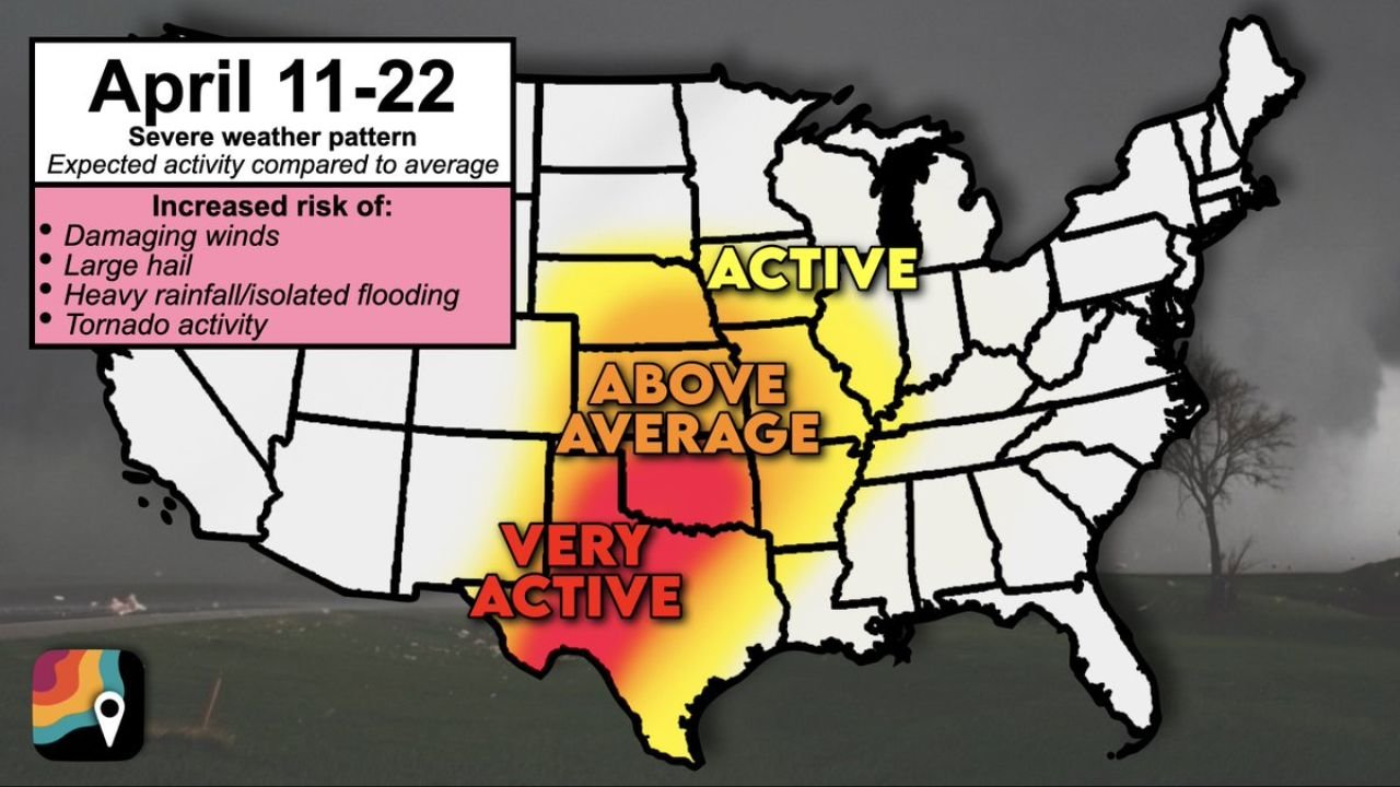
UNITED STATES — A major severe weather pattern is now setting up across the central United States, and the latest outlook shows a significant ramp-up in storm activity from Texas through Oklahoma, Kansas, Nebraska, and into parts of Iowa and the Corn Belt between April 11 and April 22.
This developing setup signals one of the most active stretches of severe weather so far this season, with conditions increasingly favorable for tornadoes, damaging winds, large hail, and heavy rainfall across a broad portion of the Plains and Midwest.
Tornado Alley Now Entering High Alert Period
The pattern strongly favors classic Tornado Alley, including:
- Texas
- Oklahoma
- Kansas
- Nebraska
These areas are expected to see above-average to potentially hyperactive storm development, especially as the season begins transitioning toward peak severe weather months.
Texas, in particular, stands out as a primary focal point, where conditions could become especially volatile during this period.
Expanding Risk Into the Midwest and Corn Belt
Beyond the Plains, the severe weather zone is expected to extend into:
- Iowa
- Parts of the Midwest
These regions are projected to experience active storm conditions, though generally slightly lower intensity compared to the southern Plains. Still, the setup supports:
- Strong thunderstorms
- Occasional severe outbreaks
- Increasing tornado potential during peak days
Atmospheric Setup Favors Severe Storm Development
The driving force behind this pattern is a persistent western U.S. trough, or dip in the jet stream, which plays a key role in severe weather outbreaks.
This setup will:
- Pull cooler air southward over the Rockies
- Allow warm, moisture-rich air to surge northward from the Gulf
- Create a strong clash of air masses across the Plains
That collision zone becomes the breeding ground for organized thunderstorms and severe weather events.
Dryline and Storm Formation Across Texas and Plains
A critical feature in this setup is the dryline in western Texas, which separates:
- Dry desert air to the west
- Moist Gulf air to the east
As this boundary sharpens, it becomes a prime trigger zone for thunderstorm development, especially during the late afternoon and evening hours.
Storms forming along this boundary can quickly intensify into:
- Supercells
- Large hail producers
- Tornado-producing storms
Jet Stream Dynamics Increasing Tornado Risk
Strong winds in the upper atmosphere will enhance storm organization.
As storms grow vertically, they will interact with:
- Wind shear (changing wind speeds and directions with height)
- Jet stream energy overhead
This combination significantly increases the chance that some storms will rotate, leading to a heightened tornado risk across multiple states.
Confidence Growing But Daily Details Still Evolving
While confidence is high in the overall active pattern, exact details such as:
- Specific outbreak days
- Storm timing
- Exact locations of highest risk
are still being refined and will become clearer as the timeframe gets closer.
Residents Urged to Prepare Now
With a prolonged stretch of severe weather expected, this is the time for residents across the Plains and Midwest to:
- Review severe weather safety plans
- Ensure access to reliable warning systems
- Identify safe shelter locations
- Prepare for rapid weather changes
This period could bring multiple rounds of storms, not just a single event.
A Potentially Defining Stretch of Severe Weather Season
The April 11–22 window is shaping up to be a high-impact period across Tornado Alley and nearby regions, with repeated opportunities for severe storms.
From Texas through Oklahoma, Kansas, Nebraska, and into Iowa, the message is clear:
Conditions are aligning for a dangerous and active severe weather phase.
Stay with WaldronNews.com for continuous updates as this evolving situation becomes clearer and specific threat days are identified.