
Texas, Oklahoma, Tennessee, North Carolina, and Virginia Face Potentially Historic Snow and Ice Storm This Weekend
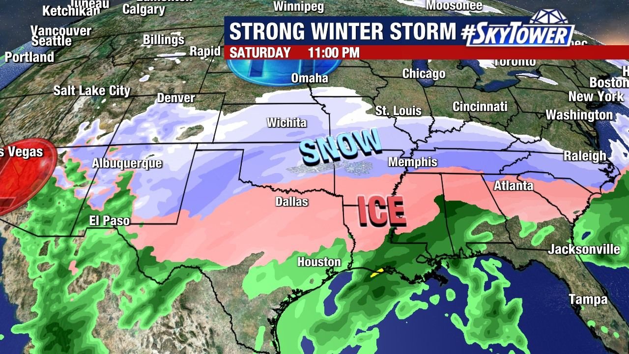
ARKANSAS — A major winter storm is increasingly likely to impact a large portion of the southern and eastern United States this weekend, with updated forecast data showing exceptionally high confidence for widespread snow and dangerous ice from Texas through the Mid-South and into the Carolinas and Virginia.
Recent model guidance and probability maps now indicate 90–95% odds of at least impactful winter weather across Oklahoma and North Texas on Saturday, followed by Tennessee, North Carolina, and Virginia on Sunday. Meteorologists note that signals this strong have not appeared in decades, raising concern that this could become one of the most memorable winter storms in a generation for several states.
Snow vs. Ice: Sharp Dividing Line Expected
Forecast maps continue to highlight a classic but dangerous setup:
- Heavy snow north of the storm track
- Significant ice accumulation just south of it
Mountain areas of North Georgia, eastern Tennessee, western North Carolina, and southwest Virginia could see 6 to 12 inches of snow, with localized totals exceeding one foot if bands stall. At the same time, Metro Atlanta, central Alabama, Mississippi, and parts of Texas and Arkansas are at risk for damaging ice accretion, a combination that often leads to power outages and impassable roads.
Meteorologists emphasize that the transition from heavy snow to little or no accumulation may occur over just 50–100 miles, making final totals highly sensitive to small track shifts.
Tennessee: High-End Snow Potential Along the I-40 Corridor
Among the areas drawing the most attention is middle and west Tennessee, including Nashville. Some model output suggests 18–24 inches of snow in parts of the I-40 corridor, a scenario that would place this storm among the top 10 snowfall events in Nashville’s recorded history.
For context:
- Nashville has only recorded 10 inches or more of snow seven times
- The largest single storm brought 17.3 inches in March 1892
- The most recent major event delivered 11.3 inches in February 1979
While these numbers are not yet locked in, forecasters say confidence in a major snow event is growing, especially given the strength of the Arctic air mass feeding into the system.
Extreme Cold Raises the Stakes
Compounding the threat is exceptionally cold air, with temperatures forecast to fall into the single digits and teens across much of the Mid-South and Southeast. Some locations could challenge records set in the 1960s and 1980s.
This combination of ice, snow, and prolonged sub-freezing temperatures significantly increases the risk of:
- Extended power outages
- Burst pipes
- Dangerous travel conditions lasting several days
Forecasters warn this is “not a good combo”, especially in regions less accustomed to long-duration winter storms.
Model Agreement Is Improving — But Details Still Uncertain
Both the European (ECMWF) and Canadian (GEM) models are now showing better alignment in timing and storm track, lending confidence to the overall threat. However, experts caution that:
- Models can still trend north or south
- Ice vs. snow placement remains the biggest uncertainty
- Final snowfall totals will not be issued until confidence improves further
The storm is expected to begin late Saturday, intensify through Sunday, and gradually exit by Monday, potentially impacting travel plans across multiple states.
What Residents Should Do Now
Even though exact totals are still being refined, preparations should begin immediately, especially in areas highlighted for ice and heavy snow.
Key steps include:
- Avoid unnecessary travel this weekend
- Charge devices and prepare for power outages
- Have food, water, and medications ready for several days
- Monitor local forecasts frequently for updates
Stay Connected With Waldron for Updates
This is a rapidly evolving winter weather situation, and forecast details will continue to change as new data arrives. Waldron will provide ongoing updates, breakdowns by region, and timing adjustments as confidence increases.
What are conditions like where you live? Are you preparing for snow or ice? Share your local observations and stay informed with the latest updates at Waldron.