
Texas Panhandle and Southwest Oklahoma Bracing for Potential Intense Evening Supercells as Large Hail Threat Grows
TEXAS PANHANDLE & SOUTHWEST OKLAHOMA — I’m closely watching a developing severe weather setup this evening across the Texas Panhandle and parts of southwest Oklahoma, where atmospheric conditions appear supportive of intense supercell thunderstorms capable of producing very large hail and damaging winds.
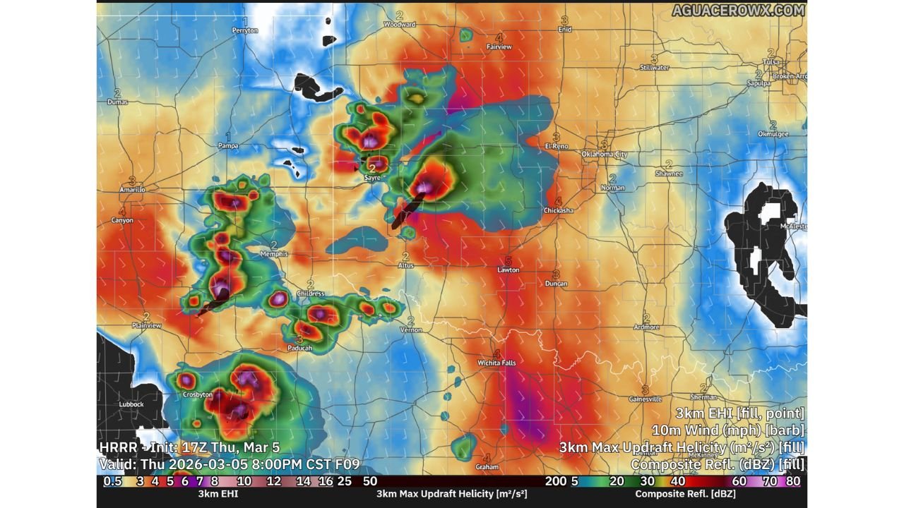
Based on the latest high-resolution model guidance and radar analysis, storms could begin organizing during the late afternoon and evening hours, particularly in areas stretching from near Amarillo and Pampa in the Texas Panhandle toward Sayre, Altus, and surrounding areas of southwest Oklahoma.
While the tornado threat remains somewhat uncertain at the moment, a strong tornado cannot be ruled out if storms manage to break through the cap and mature in the right environment.
Supercells May Develop Near the Texas–Oklahoma Border
The latest model runs suggest isolated storms could begin forming across western sections of the Texas Panhandle, gradually strengthening as they track east or northeast toward the Texas–Oklahoma border region.
Areas that could see developing storms include:
- Amarillo
- Pampa
- Shamrock
- Sayre
- Altus
- Childress
- Wellington
If storms initiate in this corridor, the environment may allow them to quickly organize into supercells, which are rotating thunderstorms capable of producing the most intense forms of severe weather.
Right now, the most likely window for storm development appears to be during the early evening hours, with activity potentially continuing into the night.
Very Large Hail Could Be the Main Threat
One of the biggest concerns this evening is very large hail.
The atmospheric setup across the Texas Panhandle and southwest Oklahoma shows strong updraft potential, which allows hailstones to remain suspended in the storm for longer periods, growing larger as they cycle through powerful updrafts.
In the strongest supercells, hail could potentially reach significant sizes capable of damaging vehicles, roofs, and crops.
Along with hail, strong wind gusts may also develop, particularly if storms organize into clusters or produce strong downdrafts.
Tornado Risk Depends on Breaking the Cap
The biggest question tonight is whether storms can overcome a strong inversion layer, often referred to as the cap.
This cap is essentially a layer of warmer air above the surface, which suppresses thunderstorm development by preventing rising air from continuing upward.
If storms remain weak, the cap could limit severe weather. However, if storms manage to punch through this layer, the environment still contains enough low-level wind shear to support rotating storms and potential tornadoes.
Storms Could Become Cyclic Supercells
Another possibility in this setup is the development of cyclic supercells, where storms repeatedly reorganize and produce multiple rotating updrafts.
Rather than producing a single long-track tornado, storms in this environment may produce multiple shorter-lived tornadoes or repeated severe weather bursts.
Even without tornadoes, cyclic supercells are often responsible for extreme hail events and damaging wind outbreaks.
Evening Timing Could Increase Risk
Storm development may occur later in the evening or even after sunset, which adds another concern.
Nighttime storms can be harder to see and track without radar, making it even more important for residents to stay alert to warnings and updates.
Right now, the key factor will be whether storms can break through the cap and fully organize.
If they do, rapid intensification into powerful supercells will be possible across the Texas Panhandle and southwest Oklahoma tonight.
Stay with WaldronNews as I continue monitoring radar and forecast updates through the evening for any rapidly developing severe storms.